
National Register of Historic Places listings in Onondaga County, New York facts for kids

Welcome to Onondaga County, New York! This area is full of amazing old buildings and places that tell stories about the past. Many of these special spots are listed on the National Register of Historic Places. This is like a national list of important historical sites in the United States.
In Onondaga County, there are 164 places on this list. A big part of these, 55 to be exact, are found outside the main city of Syracuse. This article will tell you about some of these cool historic places in the rest of the county. One very long and important site, the New York State Barge Canal, even goes through both Syracuse and other parts of the county!
Contents
What is the National Register of Historic Places?
The National Register of Historic Places is the official list of buildings, districts, sites, structures, and objects in the United States that are important in American history, architecture, archaeology, engineering, and culture. It's like a special club for places that are worth protecting and remembering. When a place is on this list, it means it's recognized for its historical value. This helps people understand and appreciate the past.
Historic Places in Onondaga County
Onondaga County has many unique places that have been added to the National Register. These sites include everything from old houses and schools to entire historic neighborhoods and even parts of canals! Let's explore some of these fascinating locations.
Cool Old Buildings and Homes
Many of the historic places in Onondaga County are beautiful old houses and buildings. They show us how people lived and what kind of architecture was popular long ago.
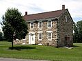
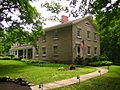
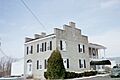
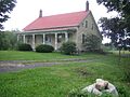
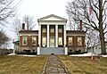
Alvord House
The Alvord House in Salina is a stone farmhouse that belonged to the Alvord family. They were important merchants in the early 1800s, especially in the salt-making business that was big in the Salina area. It's a great example of early 19th-century homes.
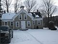
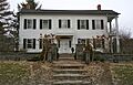
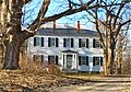
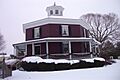
Dan Bradley House
In Marcellus, you can find the Dan Bradley House. This old home gives us a peek into the history of the village and how it grew over time.
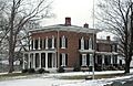
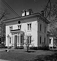
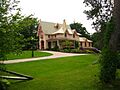
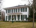
Charles Estabrook Mansion
The Charles Estabrook Mansion in Fayetteville is a grand house that shows off the fancy styles of its time. It's a significant piece of local history and architecture.
Gen. Orrin Hutchinson House
The Gen. Orrin Hutchinson House is located in Onondaga. This house belonged to General Orrin Hutchinson, an important figure from the past. It stands as a reminder of the people who shaped the area.
Dr. John Ives House
In Jamesville, the Dr. John Ives House is another historic home. It tells us about the lives of important community members, like Dr. John Ives, who lived there.
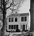
Reuel E. Smith House
The Reuel E. Smith House in Skaneateles is a very special home. It was designed by a famous architect named Alexander Jackson Davis. This makes it an important example of architectural design from its era.
Wilcox Octagon House
The Wilcox Octagon House in Camillus is quite unique because of its eight-sided shape! Octagon houses were a popular, but unusual, style in the mid-1800s. This house is a cool example of that trend.
Important Historic Districts
Sometimes, it's not just one building that's historic, but a whole group of buildings or an entire neighborhood. These are called historic districts.
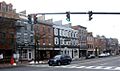
Elbridge Village Historic District
The Elbridge Village Historic District includes many buildings along Route 5 in Elbridge. This district shows how the village developed over time, with different styles of buildings from various periods.
Fabius Village Historic District
In Fabius, the Fabius Village Historic District covers a central part of the village. It includes several streets and buildings that together tell the story of Fabius's past.
Genesee Street Hill-Limestone Plaza Historic District
The Genesee Street Hill-Limestone Plaza Historic District in Fayetteville is another area with many historic buildings. It shows the growth and changes of Fayetteville's main street over the years.
Jordan Village Historic District
The Jordan Village Historic District in Jordan includes many important streets and buildings. This district helps preserve the historic look and feel of the village center.
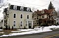
Manlius Village Historic District
The Manlius Village Historic District covers several streets in Manlius, including Pleasant, Franklin, and East Seneca Streets. This area is known for its well-preserved historic homes and buildings.
Skaneateles Historic District
The Skaneateles Historic District is a beautiful area in the village of Skaneateles. It includes streets like Jordan, Fennell, and Genesee, showcasing the village's charming historic architecture.
Schools and Churches with History
Many old schools and churches in Onondaga County are also on the National Register. These buildings were often central to community life.
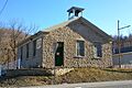
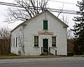
Borodino District School No. 8
The Borodino District School No. 8 in Borodino is an old schoolhouse. These one-room or small schools were once common and played a big role in educating children in rural areas.
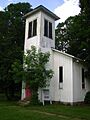
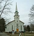
Delphi Baptist Church
The Delphi Baptist Church in Delphi Falls is a historic church building. Churches often served as important gathering places for communities, not just for worship but also for social events.
First Baptist Church of Camillus
The First Baptist Church of Camillus is another historic church. Its architecture and history reflect the community's development.
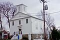
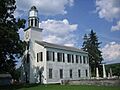
Oran Community Church
The Oran Community Church in Pompey is a significant local landmark. It has served the community for many years and holds a special place in its history.
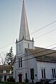
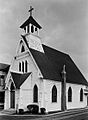
Saint Mark's Church
In Jamesville, Saint Mark's Church is a historic religious building. Its design and age make it an important part of the area's heritage.
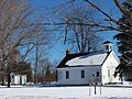
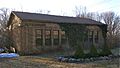
Southwood Two-Teacher School
The Southwood Two-Teacher School in Jamesville is an example of a slightly larger rural schoolhouse. It shows how education evolved from single-teacher schools.
Stone Arabia School
The Stone Arabia School in Cicero is another historic school building. It reminds us of the past educational system in the county.
Unique Sites and Structures
Beyond houses and churches, Onondaga County also has unique structures and sites that are historically important.
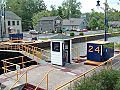
New York State Barge Canal
The New York State Barge Canal is a huge historic site that runs across many parts of Onondaga County, including Baldwinsville, Liverpool, and Salina. This canal system was built in the early 1900s to replace the famous Erie Canal. It helped New York compete with railroads for moving goods and people. It's an amazing feat of engineering!
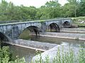
Nine Mile Creek Aqueduct
The Nine Mile Creek Aqueduct near Camillus is a fascinating structure. An aqueduct is like a bridge that carries water, often for a canal. This one was part of the old canal system and is a great example of historic engineering.
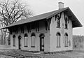
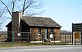
Martisco Station
The Martisco Station is an old train station. Train stations were once bustling hubs of activity, connecting towns and cities. This station tells the story of transportation in the past.
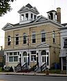
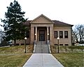
Solvay Public Library
The Solvay Public Library is a historic building that has served as a center for learning and community gathering in Solvay. Libraries are important places for knowledge and culture.
Images for kids
-
Alvord House
-
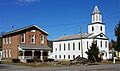
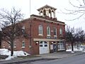
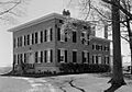
Baldwinsville Village Hall
-

Borodino District School No. 8
-
Borodino Hall
-
Dan Bradley House
-
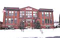
Camillus Union Free School
-
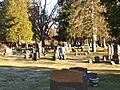
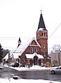
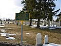
Christ Church and Manlius Village Cemeteries
-
Church of the Good Shepherd
-
Community Place
-
Mrs. I. L. Crego House
-
Delphi Baptist Church
-
Delphi Village School
-
Drover's Tavern
-
Elbridge Village Historic District
-
Charles Estabrook Mansion
-
Fabius Village Historic District
-
First Baptist Church of Camillus
-
James and Lydia Canning Fuller House
-

Genesee Street Hill-Limestone Plaza Historic District
-
Lucius Gleason House
-
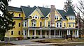
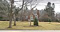
Hazelhurst
-
Gen. Orrin Hutchinson House
-
Dr. John Ives House
-
Jordan Village Historic District
-
Kelsey-Davey Farm
-
Manlius Village Historic District
-
Martisco Station
-
Mycenae Schoolhouse
-
New York State Barge Canal
-
Nine Mile Creek Aqueduct
-
Oran Community Church
-
Oran District No. 22 Schoolhouse
-
Oswego-Oneida Streets Historic District
-
Pompey Centre District No. 10 Schoolhouse
-
Saint Mark's Church
-
Shepard Settlement Cemetery
-
Skaneateles Historic District
-
Reuel E. Smith House
-
Levi Snell House
-
Solvay Public Library
-
Southwood Two-Teacher School
-
Stone Arabia School
-
Tefft-Steadman House
-
Whig Hill and Dependencies
-
Wilcox Octagon House


.jpg)


.jpg)


.jpg)


.jpg)


.jpg)


.jpg)

