
National Register of Historic Places listings in Panola County, Mississippi facts for kids

Have you ever wondered about the old buildings and special places in your town or county? Many places in the United States are so important because of their history or unique design that they are added to a special list called the National Register of Historic Places. This list helps protect these treasures for future generations.
This article is all about the amazing historic places found in Panola County, Mississippi. There are 28 different properties and areas in Panola County that are on this important list. These places include old homes, historic parts of towns, and even ancient sites.
What is the National Register of Historic Places?
The National Register of Historic Places is like a special club for buildings, sites, and objects that are important to American history, architecture, archaeology, engineering, or culture. It's managed by the National Park Service, which is part of the United States government. When a place is added to this list, it means it's recognized as a valuable part of our shared past.
Being on the National Register doesn't mean a place can't be changed or sold. However, it does encourage people to preserve these sites. It can also help owners get special grants or tax benefits to help take care of these historic properties. It's a way to celebrate and protect the stories and structures that make our country unique.
Panola County's Historic Treasures
Panola County is full of history, and its 28 listed places show just how rich its past is. These sites are spread across different towns in the county, like Sardis, Batesville, and Como. Each one tells a part of the county's story.
Homes with History
Many of the places on the list are old homes. These houses often show us how people lived long ago and what kind of architecture was popular. For example, the Ballentine-Bryant House and the Ballentine-Seay House in Sardis are beautiful examples of historic homes. The Hall-Roberson House and the Hufft House, also in Sardis, are other notable residences. These homes often have unique designs and tell tales of the families who once lived there.
Important Places in Towns
Beyond individual houses, entire parts of towns can be listed as "historic districts." This means a whole area, with many buildings, is important together. The Batesville Historic District and the Como Commercial Historic District are examples of this. These districts help preserve the look and feel of old downtown areas.
Other important buildings include churches, like the Fredonia Church and the Holy Innocents' Episcopal Church in Como. These churches often served as community centers for many years. There's also the Judge John William Kyle Law Office in Sardis, which gives us a glimpse into the legal history of the county. Even a former shop, the Popular Price Store in Como, is recognized for its role in the town's past.
Ancient Sites and Mounds
Panola County also has very old sites that tell us about people who lived there long before modern towns were built. These are often archaeological sites, like the Batesville Mounds, Fredrickson No. 2, Holly Grove Site, and Hunt Mound. These "mounds" are often ancient earthworks built by Native American cultures. They are incredibly important for understanding the early history of the region and the people who lived there thousands of years ago. Because these sites are so fragile and important, their exact locations are often kept secret to protect them.
Why is it Important to Protect These Places?
Protecting historic places is important for many reasons. They help us learn about our past, understand how our communities grew, and appreciate the skills of people who came before us. These sites are like giant history books that we can walk through and experience. By preserving them, we ensure that future generations can also learn from and enjoy these special parts of Panola County's heritage.
Images for kids
-
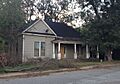
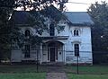
The Ballentine-Bryant House in Sardis, a historic home.
-

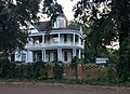
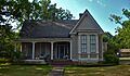
The Hall-Roberson House, another historic residence in Sardis.
-
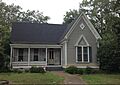
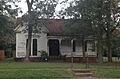
The Hufft House, located on Pocahontas Street in Sardis.
-
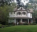
The John Curtis Kyle House in Sardis.
-
The Lee House in Batesville.
-
Short's Hill, a historic property in Sardis.
-
The Taylor-Falls House in Como.
-
The Taylor-Wall-Yancy House in Sardis.
-
The Walton-Howry House in Sardis.


