
National Register of Historic Places listings in Pulaski County, Kentucky facts for kids

Have you ever wondered about old buildings or special places in your town? Some places are so important that they are put on a special list called the National Register of Historic Places. This list helps protect buildings, sites, and objects that have a big story to tell about American history. Pulaski County, Kentucky, has many such amazing places! There are 39 places in Pulaski County on this list, and one of them is even a National Historic Landmark, which means it's extra important to the whole country.
What is the National Register of Historic Places?
The National Register of Historic Places is the official list of places in the United States that are worth saving. These places can be buildings, structures, objects, sites, or even entire historic districts. They are chosen because they are important to the history, architecture, archaeology, engineering, or culture of a community, state, or the nation.
When a place is added to the National Register, it means it's recognized for its historical value. This can help protect it from being torn down or changed too much. It also helps people learn about the past and appreciate the stories these places hold.
Historic Places in Pulaski County
Pulaski County, Kentucky, is home to many fascinating historic sites. These places tell us about different times in history, from important battles to how people lived and worked long ago. Let's explore some of these special locations.
Battle of Mill Springs Historic Areas
One of the most important historic sites in Pulaski County is the Battle of Mill Springs Historic Areas. This place is so significant that it's a National Historic Landmark! The Battle of Mill Springs was a major event during the American Civil War. It happened on January 19, 1862. This battle was a big victory for the Union (Northern) forces and helped them gain control in Kentucky.
The historic area includes three different parts: one near Nancy, one in Mill Springs, and another across the Cumberland River. These areas help us understand where the battle took place and remember those who fought there.
Monuments and Cemeteries
Pulaski County also has important monuments and cemeteries that honor historical events and people.
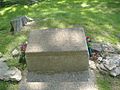
Battle of Dutton's Hill Monument
The Battle of Dutton's Hill Monument is located near Somerset. This monument remembers another Civil War battle that happened on March 30, 1863. It was a smaller battle, but still an important part of the war's history in Kentucky. The monument helps keep the memory of this event alive.
Confederate Mass Grave Monument in Nancy
In Nancy, you can find the Confederate Mass Grave Monument in Nancy. This monument is in Zollicoffer Park Cemetery. It marks a mass grave for Confederate soldiers who died during the Battle of Mill Springs. It's a solemn place that reminds us of the human cost of war.
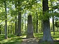
Gen. Felix K. Zollicoffer Monument
Also in Zollicoffer Park Cemetery in Nancy is the Gen. Felix K. Zollicoffer Monument. General Felix K. Zollicoffer was a Confederate general who was killed during the Battle of Mill Springs. This monument honors his memory and is another important part of the battlefield's history.
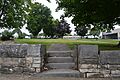
Mill Springs National Cemetery
The Mill Springs National Cemetery is also in Nancy. This cemetery is a burial ground for soldiers who served in the U.S. military, including many from the Civil War. It's a place of respect and remembrance for those who gave their lives for their country.
Historic Homes and Buildings
Many old houses and buildings in Pulaski County are on the National Register. These structures show us how people lived and what kind of architecture was popular in the past.
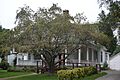
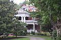
Beatty-Newell House
The Beatty-Newell House near Bronston is an example of an old home that has been preserved. It gives us a peek into the lives of families who lived in the area long ago.
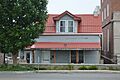
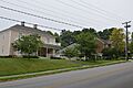
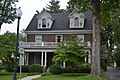
Boland House
In Burnside, the Boland House on Lakeshore Drive is another historic home. It's part of the rich history of the town of Burnside.
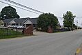
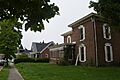
Burnside Historic District
The town of Burnside has an entire Burnside Historic District. This means that a whole area, including Lakeshore Drive and French Avenue, has many historic buildings together. Walking through this district is like stepping back in time!
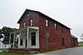
Burnside Masonic Lodge
The Burnside Masonic Lodge is a historic building in Burnside. Masonic lodges are meeting places for a fraternal organization called the Freemasons, which has a long history in the United States.
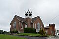
Burnside Methodist Church
The Burnside Methodist Church is another historic building in Burnside. Old churches often have beautiful architecture and tell stories about the community's faith and growth over many years.
Crawford House
In Somerset, the Crawford House on Maple Street is a historic residence. It's one of many old homes that contribute to the town's unique character.
A. Jackson Crawford Building
The A. Jackson Crawford Building on South Main Street in Somerset is a historic commercial building. It shows us what downtown areas looked like when they were first developing.
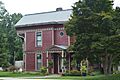
William Fox House
The William Fox House on West Columbia Street in Somerset is another example of a well-preserved historic home.
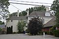
Gover-Hardin House
The Gover-Hardin House on West Mt. Vernon Street in Somerset is a historic home that has been recognized for its importance.
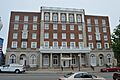
Hotel Beecher
The Hotel Beecher on South Main Street in Somerset was once a busy hotel. Hotels are important because they show how people traveled and stayed in towns in the past.
Dr. John Milton Perkins House
The Dr. John Milton Perkins House on North Main Street in Somerset belonged to an important person in the community. Often, homes are listed because of the famous or influential people who lived there.
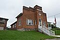
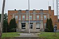
Somerset Armory
The Somerset Armory on Grand Avenue is a historic building that was used by the military or National Guard. Armories are often strong, impressive buildings.
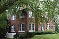
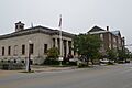
Somerset City School and Carnegie Library
The Somerset City School and Carnegie Library on College Street is a special place. Carnegie Libraries were built all over the country with money from Andrew Carnegie, a very rich businessman who believed in the importance of education and reading.
Historic Districts in Somerset
Somerset has several historic districts, which means entire neighborhoods or parts of the downtown area are recognized for their historical value.
Harvey's Hill Historic District
The Harvey's Hill Historic District includes parts of North Main Street. These districts help preserve the look and feel of older neighborhoods.
North Main Street Historic District
The North Main Street Historic District includes parts of North Main and Columbia Streets. It's a key part of Somerset's historic downtown.
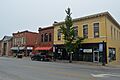
Somerset Downtown Commercial District
The Somerset Downtown Commercial District covers parts of East Mt. Vernon Street. This area was once the bustling center of business and trade in Somerset.
South Courthouse Square Historic District
The South Courthouse Square Historic District includes Public Square and nearby streets. Courthouses are often central to a town's history, and the surrounding area grows with it.
West Columbia Street District
The West Columbia Street District is another historic area in Somerset, preserving the character of its old streets and buildings.
Former Listing
Sometimes, a property is removed from the National Register. This can happen if the building is changed too much, or if it is torn down. The City Hall in Somerset was once on the list but was removed in 2012.
Images for kids
-

Battle of Dutton's Hill Monument
-

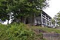
Cumberland River at Mill Springs
-
Beatty-Newell House
-
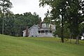
Boland House in Burnside
-
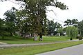
Lakeshore west of French in Burnside
-
Burnside Masonic Lodge
-
Burnside United Methodist Church
-
Confederate Mass Grave Monument in Nancy
-
Crawford House
-
A. Jackson Crawford Building
-
William Fox House
-
Gover-Hardin House
-
Harvey's Hill in Somerset
-
Hotel Beecher
-

Mill Springs National Cemetery
-
Morrow House
-
North Main Street Historic District
-

Parker House
-
Dr. John Milton Perkins House
-
Dill Scott House
-
Smith House
-
Beecher Smith House
-
Somerset Armory
-

Somerset City School and Carnegie Library
-

Somerset Downtown Commercial District
-
South Courthouse Square Historic District
-
US Post Office-Bronston
-
Waddle-Prather House
-
West Columbia Street District
-
Withers House
-
Gen. Felix K. Zollicoffer Monument


