National Register of Historic Places listings in Putnam County, Indiana facts for kids
This article is about the amazing old buildings and places in Putnam County, Indiana that are listed on the National Register of Historic Places. Think of this register as a special list of important historical sites across the United States. These places are chosen because they tell us a lot about the past, like how people lived, what they built, and important events that happened there.
When a place is on this list, it means it's recognized for its historical, architectural, or cultural importance. It helps protect these sites so future generations can learn from them too!
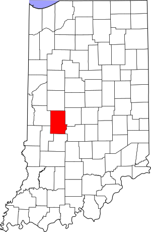
In Putnam County, Indiana, there are 25 places currently on this special list. One other place was on the list but has since been removed. You can even see where many of these places are on a map, thanks to their latitude and longitude coordinates!
Some of these special places are in towns, and their names show the town they are in. Others are in the countryside, and their names show the larger area they belong to, called a civil township. If a place is in more than one area, all the names are listed.
Historic Places in Putnam County
This section lists all the places in Putnam County that are currently on the National Register of Historic Places. Each entry tells you a little about the place, where it is, and when it was added to the list.
| Name on the Register | Image | Date listed | Location | City or town | Description | |
|---|---|---|---|---|---|---|
| 1 | The Boulders |
(#93000948) |
835 E. Washington St. 39°38′39″N 86°50′46″W / 39.644167°N 86.846111°W |
Greencastle | ||
| 2 | Brick Chapel United Methodist Church |
(#03000973) |
3547 N. U.S. Route 231 at Brick Chapel 39°42′43″N 86°52′07″W / 39.711944°N 86.868611°W |
Monroe Township | ||
| 3 | Samuel Brown House |
(#06000520) |
1558 E. County Road 1100N, southwest of Roachdale 39°49′N 86°49′W / 39.82°N 86.82°W |
Franklin Township | ||
| 4 | Courthouse Square Historic District |
(#84001237) |
Roughly bounded by College Ave., Walnut, Market, and Franklin Sts. 39°38′38″N 86°51′52″W / 39.643889°N 86.864444°W |
Greencastle | ||
| 5 | Delta Kappa Epsilon Fraternity House |
(#96000291) |
620 Anderson St. 39°38′24″N 86°51′05″W / 39.64°N 86.851389°W |
Greencastle | ||
| 6 | East College of DePauw University |
(#75000047) |
300 Simpson St. 39°38′24″N 86°51′42″W / 39.64°N 86.861667°W |
Greencastle | ||
| 7 | Eastern Enlargement Historic District |
(#11000387) |
Roughly bounded by E. Franklin, Wood, Anderson, and College Sts. 39°38′30″N 86°51′22″W / 39.641667°N 86.856111°W |
Greencastle | ||
| 8 | Forest Hill Cemetery |
(#15000598) |
2181 S50W 39°37′42″N 86°51′29″W / 39.628333°N 86.858056°W |
Greencastle Township | ||
| 9 | Richard M. Hazelett House |
(#06000304) |
911 E. Washington St. 39°38′39″N 86°50′38″W / 39.644167°N 86.843889°W |
Greencastle | ||
| 10 | Alfred Hirt House |
(#91000274) |
W. Walnut Street Rd., west of Greencastle 39°38′42″N 86°52′27″W / 39.645°N 86.874167°W |
Greencastle Township | ||
| 11 | Melville F. McHaffie Farm |
(#83003600) |
U.S. Route 40, southwest of Stilesville 39°37′47″N 86°39′38″W / 39.629722°N 86.660556°W |
Jefferson Township | ||
| 12 | McKim Observatory, DePauw University |
(#78000051) |
DePauw and Highbridge Aves. 39°38′44″N 86°51′09″W / 39.645556°N 86.852500°W |
Greencastle | ||
| 13 | F.P. Nelson House |
(#83000092) |
701 E. Seminary 39°38′31″N 86°51′12″W / 39.641944°N 86.853333°W |
Greencastle | ||
| 14 | Northwood Historic District |
(#11000388) |
Roughly bounded by Shadowlawn, N. Arlington, E. Franklin, and Hillsdale Aves. 39°38′44″N 86°51′16″W / 39.645556°N 86.854444°W |
Greencastle | Historic Residential Suburbs in the United States, 1830-1960 MPS | |
| 15 | James Edington Montgomery O'Hair House |
(#91001909) |
U.S. Route 231 ½ mile south of its junction with 500 North Rd. and north of Brick Chapel 39°43′36″N 86°52′04″W / 39.726667°N 86.867778°W |
Monroe Township | ||
| 16 | Old Greencastle Historic District |
(#11000389) |
Roughly bounded by W. Liberty, Market, W. Poplar, and W. Gillespie Sts. 39°38′44″N 86°52′03″W / 39.645556°N 86.8675°W |
Greencastle | ||
| 17 | Putnam County Bridge No. 159 |
(#99000302) |
County Road 650W over Big Walnut Creek at Reelsville 39°33′17″N 86°57′51″W / 39.554722°N 86.964167°W |
Washington Township | ||
| 18 | Putnamville Presbyterian Church |
(#84001242) |
State Road 243 at Putnamville 39°34′25″N 86°51′54″W / 39.573611°N 86.865°W |
Warren Township | ||
| 19 | Lycurgus Stoner House |
(#85002134) |
Manhattan Rd., southwest of Greencastle 39°34′58″N 86°54′55″W / 39.582778°N 86.915278°W |
Washington Township | ||
| 20 | William C. Van Arsdel House |
(#84001246) |
125 Wood St. 39°38′31″N 86°51′00″W / 39.641944°N 86.85°W |
Greencastle |
Former Listings
Sometimes, a place might be removed from the National Register of Historic Places. This can happen for different reasons, like if the building is changed too much or if it's no longer standing. Here is one place that was once on the list in Putnam County but has since been removed.
| Name on the Register | Image | Date listed | Date removed | Location | City or town | Summary | |
|---|---|---|---|---|---|---|---|
| 1 | Appleyard |
(#90000325) |
|
Southern side of State Road 240, east of Greencastle 39°38′19″N 86°49′08″W / 39.638611°N 86.818889°W |
Greencastle Township |


