
National Register of Historic Places listings in Randolph County, Illinois facts for kids

Welcome to Randolph County, Illinois! This special place is home to many important historical sites. These sites are so important that they are listed on the National Register of Historic Places. Think of it like a special list of buildings, places, and areas that tell us about the past. They are protected and celebrated because they teach us about history.
In Randolph County, there are 18 places on this list. Three of them are even more special and are called National Historic Landmarks. These landmarks are recognized for being super important to the history of the entire United States!
Contents
Discovering Randolph County's Historic Places
Randolph County has a rich history, from ancient times to more recent days. Let's explore some of the amazing places that are preserved here.
Ancient Homes and Shelters
Some of the oldest sites in Randolph County show us how people lived thousands of years ago.
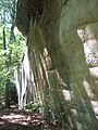
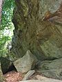
Modoc Rock Shelter
The Modoc Rock Shelter is a very old place where people lived a long, long time ago. It's like a natural cave or overhang in the rocks. Scientists have found tools and other items here that show us how early people survived. It helps us understand what life was like for the first people in Illinois.
- Located near Modoc.
- Added to the National Register on October 15, 1966.
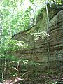
Piney Creek Sites
In the Piney Creek Ravine Nature Preserve, there are several important archaeological sites:
- Piney Creek Site
- Piney Creek South Site
- Piney Creek West Site
- Tegtmeyer Site
These sites are all found near Piney Creek, close to Campbell Hill. They contain clues about ancient communities and their way of life. Scientists study these areas to learn about the people who lived there long ago.
- All three Piney Creek sites and the Tegtmeyer Site were added to the National Register on May 31, 2001.
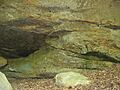
Kolmer Site
The Kolmer Site is another important archaeological spot. It's located near Prairie du Rocher. This site gives us more information about the early people who lived in this area.
- Added to the National Register on May 1, 1974.
Old Buildings and Bridges
Randolph County also has historic buildings and structures that tell stories from different times.
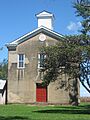
Charter Oak Schoolhouse
Imagine going to school in a building like this! The Charter Oak Schoolhouse is an old school building located west of Schuline. It shows us what schools were like in the past, with just one room for all the students.
- Added to the National Register on October 11, 1978.
Creole House
The Creole House in Prairie du Rocher is a unique old home. It's built in a special style called Creole, which was common when French settlers lived in this area. It gives us a peek into the lives of early European settlers.
- Added to the National Register on April 3, 1973.
Mary's River Covered Bridge
This beautiful covered bridge is located northeast of Chester. Covered bridges were built to protect the wooden parts of the bridge from weather, making them last longer. It's a charming reminder of how people traveled in the past.
- Added to the National Register on December 31, 1974.
Shiloh College
Shiloh College, located in Shiloh Hill, was once a place of learning. It represents the history of education in the area.
- Added to the National Register on November 15, 2005.
Important Historical Sites
Some places are important because of major events or famous people connected to them.
Fort de Chartres
Fort de Chartres is a historic fort near Prairie du Rocher. It was built by the French a long time ago to protect their land and trade routes. Today, you can visit the reconstructed fort and imagine what life was like for soldiers and settlers. It's a National Historic Landmark!
- Added to the National Register on October 15, 1966.
Pierre Menard House
The Pierre Menard House is a beautiful historic home located in Fort Kaskaskia State Park, near Ellis Grove. Pierre Menard was a very important person in Illinois history; he was the first Lieutenant Governor of Illinois. His house shows us how important people lived in the early 1800s. It's also a National Historic Landmark!
- Added to the National Register on April 15, 1970.
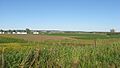
French Colonial Historic District
This large historic area stretches from Fort Chartres State Park to Kaskaskia Island. It includes many places that show the French influence in this part of Illinois. It's a whole district filled with history!
- Added to the National Register on April 3, 1974.
Red Bud Historic District
The Red Bud Historic District includes many important buildings along Main and Market Streets in Red Bud. This district shows the history and growth of the town.
- Added to the National Register on December 29, 1979.
Sparta Historic District
The Sparta Historic District includes several streets in Sparta. It highlights the historic buildings and architecture that make Sparta unique.
- Added to the National Register on June 3, 1982.
Images for kids
-
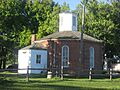
The old Charter Oak Schoolhouse.
-
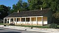
The historic Creole House.
-
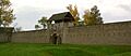
The gatehouse at Fort de Chartres.
-
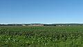
A view of the American Bottom area, part of the French Colonial Historic District.
-
The Kolmer archaeological site.
-
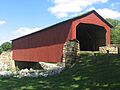
Mary's River Covered Bridge.
-
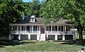
The Pierre Menard House.
-
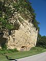
The Modoc Rock Shelter.
-
An overview of the Piney Creek Site.
-
The Piney Creek South Site.
-
The Piney Creek West Site.
-
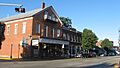
East Market Street in the Red Bud Historic District.
-
The Shiloh College building.
-
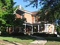
The Rosborough House in the Sparta Historic District.
-
The Tegtmeyer archaeological site.


