
National Register of Historic Places listings in Sierra County, California facts for kids

Have you ever wondered about the special places that tell stories from the past? In Sierra County, California, there are many such spots! These places are so important that they are officially listed on the National Register of Historic Places. This list helps protect and celebrate buildings, sites, and objects that have played a big part in American history.
Sierra County is a beautiful area in California, known for its mountains and forests. It's home to 14 different places that are on this special list. Each one has a unique story to share about how people lived, worked, and explored this region long ago.
Discovering Sierra County's Historic Treasures
The National Register of Historic Places is like a hall of fame for important historical sites across the United States. It's managed by the National Park Service. When a place is added to this list, it means it's recognized for its historical, architectural, archaeological, engineering, or cultural importance. This helps make sure these places are preserved for future generations to learn from and enjoy.
Why Are These Places Important?
These historic sites in Sierra County help us understand the past. They show us what life was like during the California Gold Rush, how communities were built, and even how people traveled. From old bridges to boundary markers, each site offers a glimpse into the history of California and the American West.
Cool Historic Spots in Sierra County
Let's look at some of the interesting places you can find on the National Register in Sierra County:
The 1872 California-Nevada State Boundary Marker
Imagine a time when the exact border between California and Nevada wasn't clear! This marker, placed in 1872, helped define where one state ended and the other began. It's located northwest of Verdi, Nevada, right on the state line. This simple marker tells a big story about how states were formed and their boundaries were set.
Historic Bridges of Downieville
The town of Downieville, California, has several historic bridges that are on the National Register. These include the Durgan Bridge, Hansen Bridge, Hospital Bridge, and Jersey Bridge. These bridges were vital for connecting parts of the town and helping people cross rivers like the Downie River. They show us the engineering skills of the past and how important transportation was for early communities. The Jersey Bridge, for example, connects Main Street to Commercial Street, showing how the town was laid out.
Forest City: A Glimpse into the Past
Forest City is a historic district that gives us a real feel for what a gold rush town looked like. It's located off Mountain House Road, deep within the Tahoe National Forest. Walking through Forest City is like stepping back in time to when miners sought their fortunes in the Sierra Nevada mountains. It reminds us of the exciting, and sometimes tough, lives of those who came to California during the Gold Rush.
Sierra County Sheriff's Gallows
In Downieville, California, you can find the Sierra County Sheriff's Gallows. While the name might sound a bit serious, this site is important for understanding the justice system of the past. It's located on Galloway Road and Courthouse Square. It stands as a reminder of the early legal practices and the challenges of maintaining law and order in frontier towns.
Ancient Sites: Petroglyphs and Archeological Districts
Sierra County also protects much older historical sites, some of which are kept secret to protect them. These include the Hawley Lake Petroglyphs, the Kyburz Flat Site, and the Sardine Valley Archeological District. Petroglyphs are ancient rock carvings made by early people. These sites offer clues about the lives, cultures, and beliefs of the Native American tribes who lived in this area thousands of years ago. They are incredibly valuable for understanding the very first inhabitants of California.
Foote's Crossing Road
Foote's Crossing Road, located in the Tahoe National Forest near Nevada City, California, is another historic entry. Roads like this were crucial for connecting mining camps and towns, allowing people and goods to move across the rugged landscape. It represents the early efforts to build infrastructure in the wild west.
These are just a few examples of the important places in Sierra County that are listed on the National Register of Historic Places. Each one helps us connect with the past and appreciate the rich history of this part of California.
Images for kids
-
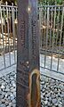
The 1872 California-Nevada State Boundary Marker.
-
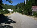
Main Street in Forest City, a historic gold rush town.
-
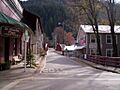
The Jersey Bridge in Downieville, connecting Main and Commercial Streets.
-
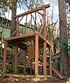
The Sierra County Sheriff's Gallows in Downieville.


