
National Register of Historic Places listings in Sierra County, New Mexico facts for kids

Welcome to Sierra County, New Mexico! This area is home to many amazing places that are super important to history. These special spots are listed on the National Register of Historic Places. Think of it like a Hall of Fame for buildings, archaeological sites, and other cool locations that tell us about the past.
When a place is on this list, it means it's recognized by the United States government as being very important for its history, architecture, or what it teaches us about people who lived long ago. In Sierra County, there are 32 such places! Every single one of these places is also listed on New Mexico's own State Register of Cultural Properties, showing how much they mean to the state.
Contents
Exploring Sierra County's Historic Places
Sierra County has a rich history, from ancient times to more recent events. Let's take a look at some of the interesting places that have been preserved for future generations.
Historic Buildings and Homes
Many buildings in Sierra County tell stories of the people who lived and worked there.
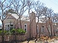
The Alert-Hatcher Building
Located in Hillsboro, the Alert-Hatcher Building was added to the National Register in 1995. It stands at the corner of 2nd Avenue and Main Street. This building is a great example of the kind of architecture you might find in historic towns in New Mexico.

William H. Bucher House
Also in Hillsboro, on West Main Street, is the William H. Bucher House. This house was listed in 1995. It's a reminder of the early residents and their homes in this historic town.
Hillsboro High School
The old Hillsboro High School building, found at the corner of Elenora Street and 1st Avenue, became a historic site in 1993. It's now known as the Hillsboro Community Center. Imagine all the students who learned and grew up within its walls!

George Tambling Miller and Ninette Stocker Miller House
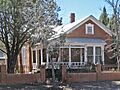
This unique house in Hillsboro, built of recycled gold ore, was added to the list in 1995. It's located on the south side of Elenora Street, near the Union Church. It's a fantastic example of Late-Victorian architecture and shows how creative builders could be with local materials.

Will M. Robins House
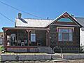
Another historic home in Hillsboro is the Will M. Robins House, listed in 1995. You can find it at the corner of Main Street and 5th Avenue. It adds to the charm and historical feel of Hillsboro.

John M. Webster House
Right across from the Will M. Robins House, at the other corner of Main Street and 5th Avenue, is the John M. Webster House. This home was also recognized in 1995, completing a historic street scene in Hillsboro.

Important Engineering and Infrastructure
Some historic places are not just buildings but also amazing feats of engineering.
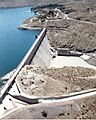
Elephant Butte Dam
The famous Elephant Butte Dam, located northwest of Elephant Butte, was listed in 1979. This massive dam creates Elephant Butte Lake, one of New Mexico's largest lakes. It's a huge part of the region's history, providing water and power.

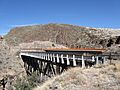
Percha Creek Bridge
The Percha Creek Bridge, built on State Road 90 over Percha Creek near Hillsboro, was added to the Register in 1997. Bridges are often important historical structures because they show how people traveled and connected different areas.

Percha Diversion Dam
Another important water structure is the Percha Diversion Dam, located northeast of Arrey. It was listed in 1979. These dams were crucial for managing water resources in the area, especially for farming.
Historic Districts and Areas
Sometimes, it's not just one building but a whole area that is historically significant. These are called historic districts.
Elephant Butte Historic District
The Elephant Butte Historic District was recognized in 1997. This area includes parts of State Road 51 and State Road 52, near the Elephant Butte Dam. It tells the story of the community that grew up around this important dam.
Hot Springs Bathhouse and Commercial Historic District in Truth or Consequences
In Truth or Consequences, there's a historic district known for its bathhouses and businesses. Listed in 2005, this area is roughly bounded by Post, Ban Patten, Pershing, and Main Streets. Truth or Consequences is famous for its natural hot springs, and this district highlights the historic buildings where people came to enjoy them.

Carrie Tingley Hospital Historic District
Also in Truth or Consequences, the Carrie Tingley Hospital Historic District was added to the Register in 2005. Located at 992 Broadway, this district includes the buildings of a hospital that has served many people over the years. It's now the New Mexico State Veterans Home.

Ancient Sites and Trails
Sierra County also holds secrets from much older times, including ancient trails and archaeological sites.
Camino Real Sections
Parts of the historic Camino Real trail are listed in Sierra County. This ancient road, used from 1598 to 1881, was a major route for trade and travel. Sections like the Jornada Lakes Section and the Point of Rocks Section near Engle and Rincon are recognized for their historical importance. These sections show where people traveled centuries ago.
Fort McRae
Near Elephant Butte, the site of Fort McRae was added to the Register in 2005. Although its exact address is restricted to protect the site, it was an important military post in the past.
Archaeological Sites
Many archaeological sites in Sierra County are listed on the National Register. These sites, like Archeological Site No. LA1119 or the Monticello Point Archeological District, are places where scientists have found clues about ancient cultures and how people lived thousands of years ago. To protect these valuable historical treasures, their exact locations are often kept secret.
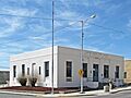
US Post Office-Truth or Consequences Main
The main post office in Truth or Consequences, located at 300 Main Street, is also a historic site, listed in 1990. Post offices often played a central role in communities, serving as communication hubs.

These are just some of the many fascinating places in Sierra County that are preserved on the National Register of Historic Places. Each one helps us understand the rich and diverse history of New Mexico!
Images for kids
-
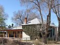
The historic Alert-Hatcher Building in Hillsboro.
-
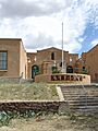
The old Hillsboro High School, now a community center.
-
The George Tambling Miller and Ninette Stocker Miller House, built with recycled gold ore.
-
The Will M. Robins House in Hillsboro.
-
The John M. Webster House in Hillsboro.
-
The impressive Elephant Butte Dam.
-
The historic Percha Creek Bridge.
-

A historic bathhouse in Truth or Consequences.
-

The historic Carrie Tingley Hospital, now the New Mexico State Veterans Home.
-
The historic US Post Office in Truth or Consequences.
