
National Register of Historic Places listings in Smith County, Texas facts for kids

This article is about the amazing historic places in Smith County, Texas! These special spots are listed on the National Register of Historic Places, which is like a hall of fame for important buildings, neighborhoods, and sites across the United States. When a place is on this list, it means it's recognized for its history, architecture, or cultural importance. It helps protect these places for future generations to enjoy and learn from.
You can even see many of these places on a map if you click on "Map of all coordinates" in the original source! Let's explore some of these cool historic locations in Smith County.
Contents
- Historic Places in Smith County
- Azalea Residential Historic District
- Blackstone Building
- Brick Streets Neighborhood Historic District
- Carnegie Public Library
- Charnwood Residential Historic District
- Cotton Belt Building
- Crescent Laundry
- Col. John Dewberry House
- Donnybrook Duplex Residential Historic District
- John B. and Ketura (Kettie) Douglas House
- East Ferguson Residential Historic District
- Elks Club Building
- D.R. Glass Library at Texas College
- Goodman-LeGrand House
- Jenkins-Harvey Super Service Station and Garage
- Martin Hall at Texas College
- Marvin Methodist Episcopal Church, South
- Moore Grocery Co. Building
- People's National Bank Building
- President's House at Texas College
- Ramey House
- Short-Line Residential Historic District
- Smith County Jail, 1881
- St. James Colored Methodist Episcopal Church
- St. John's AF & AM Lodge
- St. Louis Southwestern Railway (Cotton Belt) Passenger Depot
- Tyler City Hall
- Tyler Grocery Company
- Tyler Hydraulic-Fill Dam
- Tyler US Post Office and Courthouse
- Whitaker-McClendon House
- Williams-Anderson House
- Images for kids
Historic Places in Smith County
Many of the historic places in Smith County are found in the city of Tyler. These include old homes, churches, and even entire neighborhoods that have kept their historic charm.
Azalea Residential Historic District
This is a neighborhood in Tyler, recognized for its historic homes. It's roughly located near South Robertson Avenue, Sunnybrook Drive, and Old Bullard Road. It was added to the list in 2003.
Blackstone Building
Located at 315 North Broadway in Tyler, the Blackstone Building is a notable historic structure. It was added to the National Register in 2002.
Brick Streets Neighborhood Historic District
Another historic neighborhood in Tyler, this district is famous for its brick streets. It's generally bounded by South Broadway, West Dobbs Street, and South Kennedy Avenue. It joined the list in 2004.
Carnegie Public Library
The Carnegie Public Library, at 125 South College Street in Tyler, is a beautiful old library building. It became a historic place in 1979.
Charnwood Residential Historic District
This historic neighborhood in Tyler is roughly bounded by East Houston Street, the railroad tracks, and South Broadway. It was recognized in 1999.
Cotton Belt Building
The Cotton Belt Building, found at 1517 West Front Street in Tyler, is a historic building linked to the railway. It was added to the list in 2005.
Crescent Laundry
Located at 312-320 East Ferguson Street in Tyler, the Crescent Laundry building is another historic spot. It was recognized in 2002.
Col. John Dewberry House
This historic house is located about one mile north of Teaselville on FM 346. It's a very old and important home, listed in 1971.
Donnybrook Duplex Residential Historic District
This historic district in Tyler is roughly bounded by East 6th Street, Donnybrook Avenue, and East 8th Street. It was added to the list in 2002.
John B. and Ketura (Kettie) Douglas House
The Douglas House, at 318 South Fannin Avenue in Tyler, is a historic home. It was recognized in 1997.
East Ferguson Residential Historic District
This historic district covers addresses from 423 to 513 East Ferguson Street in Tyler. It became a historic place in 2002.
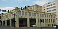
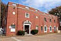
Elks Club Building
The Elks Club Building, at 202 South Broadway in Tyler, is another significant historic structure. It was added to the National Register in 2002.
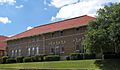
D.R. Glass Library at Texas College
Located at 2404 North Grand Avenue in Tyler, this library at Texas College is an important educational landmark. It was listed in 2007.
Goodman-LeGrand House
The Goodman-LeGrand House, at 624 North Broadway in Tyler, is a beautiful historic home. It was recognized in 1976.
Jenkins-Harvey Super Service Station and Garage
This historic service station and garage is located at 124 South College in Tyler. It was added to the list in 2002.
Martin Hall at Texas College
Also located at 2404 North Grand Avenue at Texas College in Tyler, Martin Hall is another historic building on campus. It was listed in 2005.
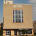
Marvin Methodist Episcopal Church, South
This historic church, at 300 West Erwin Street in Tyler, is a significant religious building. It was recognized in 2000.
Moore Grocery Co. Building
The Moore Grocery Co. Building, at 408 North Broadway in Tyler, is a historic commercial building. It was added to the National Register in 2002.
People's National Bank Building
Located at 102 North College Avenue in Tyler, this old bank building is a historic landmark. It was listed in 2002.
President's House at Texas College
Another historic building at Texas College in Tyler, the President's House is located at 2404 North Grand Avenue. It was recognized in 2007.
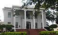
Ramey House
The Ramey House, at 605 South Broadway in Tyler, is a historic home. It was added to the list in 1982.
Short-Line Residential Historic District
This historic neighborhood in Tyler is roughly bounded by West Lane, North Ellis, and Short Street. It was recognized in 2002.
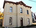
Smith County Jail, 1881
The old Smith County Jail, built in 1881, is located at 309 Erwin Street in Tyler. This historic jail was listed in 1996.
St. James Colored Methodist Episcopal Church
This historic church, at 408 North Border Avenue in Tyler, is an important part of the community's history. It was added to the list in 2004.
St. John's AF & AM Lodge
Located at 323 West Front Street in Tyler, St. John's AF & AM Lodge is a historic lodge building. It was recognized in 2005.
St. Louis Southwestern Railway (Cotton Belt) Passenger Depot
This historic railway depot, located near 100 East Oakwood Street at North Spring Street in Tyler, is an important piece of transportation history. It was listed in 2001.
Tyler City Hall
Tyler City Hall, at 212 North Bonner Avenue, is the historic seat of the city's government. It was added to the National Register in 2007.
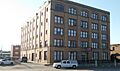
Tyler Grocery Company
The Tyler Grocery Company building, at 416 North Broadway in Tyler, is another historic commercial building. It was recognized in 2002.
Tyler Hydraulic-Fill Dam
This historic dam is located west of Tyler, off Texas State Highway 31. It was added to the list in 1977.
Tyler US Post Office and Courthouse
The United States Post Office and Courthouse in Tyler, at 211 West Ferguson Street, is a significant government building. It was listed in 2001.
Whitaker-McClendon House
The Whitaker-McClendon House, at 806 West Houston Street in Tyler, is a historic home. It was recognized in 1982.
Williams-Anderson House
Located at 1313 West Claude Street in Tyler, the Williams-Anderson House is another historic residence. It was added to the list in 2002.
Images for kids
-
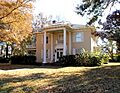
Azalea Residential Historic District
-
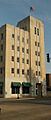
Blackstone Building
-
Carnegie Public Library
-

Cotton Belt Building
-

Crescent Laundry
-
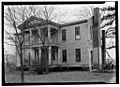
Col. John Dewberry House
-

John B. and Ketura (Kettie) Douglas House
-

East Ferguson Residential Historic District
-
Elks Club Building
-

Goodman-LeGrand House
-
Jenkins-Harvey Super Service Station and Garage
-

Marvin Methodist Episcopal Church, South
-
Moore Grocery Co. Building
-

People's National Bank Building
-
Ramey House
-

Short-Line Residential Historic District
-
Smith County Jail, 1881
-

St. James Colored Methodist Episcopal Church
-
St. John's AF & AM Lodge
-

St. Louis Southwestern Railway (Cotton Belt) Passenger Depot
-

Tyler City Hall
-

Tyler Grocery Company
-

Tyler US Post Office and Courthouse
-

Whitaker-McClendon House
-

Williams-Anderson House


