
National Register of Historic Places listings in Tishomingo County, Mississippi facts for kids

Have you ever wondered about the oldest and most important places in your state? In Tishomingo County, Mississippi, there are many special spots that are part of the National Register of Historic Places. This is a list of places in the United States that are important because of their history, architecture, or what happened there.
These places are like treasures that tell us stories about the past. They help us remember important events and people. In Tishomingo County, there are 17 such places. One place was on the list but was later removed. Let's explore some of these amazing historical sites!
What is the National Register of Historic Places?
The National Register of Historic Places is the official list of the nation's historic places. It is part of a program to help protect America's historic and archaeological sites. When a place is added to this list, it means it is special and worth saving.
Being on the list can help preserve these places. It can also make people more aware of their local history. This list includes buildings, battlefields, parks, and even ancient sites.
Amazing Places in Tishomingo County
Tishomingo County is full of interesting history. From ancient Native American sites to Civil War battlefields and old homes, there's a lot to discover.
Tishomingo State Park

Tishomingo State Park is a truly special place. It's located southeast of the junction of State Highways 25 and 30. This park is known for its beautiful rocky landscapes. It's different from most of Mississippi. The park has large boulders and cliffs. This is because it's at the very southern end of the Appalachian Mountains.
The park was added to the National Register in 1998. It's a great spot for hiking, rock climbing, and canoeing. The park also holds two ancient sites called the Bear Creek Fishweirs. These were built by Native Americans long ago.
Bear Creek Fishweirs
The Bear Creek Fishweir No. 1 and Bear Creek Fishweir No. 2 are located within Tishomingo State Park. These are ancient structures built in the creek. Native Americans used them to catch fish. They are very old and show how people lived and hunted many centuries ago. Fishweir No. 1 was listed in 2005, and Fishweir No. 2 in 2007.
Bear Creek Mound and Village Site

The Bear Creek Mound and Village Site is another important ancient place. It's found along the Natchez Trace Parkway. This site includes a large mound and the remains of an old village. Native Americans lived here a very long time ago. They built the mound for special purposes, perhaps for ceremonies or burials. This site was added to the National Register in 1988. It helps us learn about the early people who lived in this area.
Iuka Battlefield

The Iuka Battlefield is a very important historical site. It is located north of U.S. Route 72 and west of Mississippi Highway 25. This was the site of a major battle during the American Civil War. The Battle of Iuka happened here in 1862. Union and Confederate soldiers fought fiercely.
The battlefield was added to the National Register in 2007. It helps us remember the sacrifices made during this difficult time in American history. Visiting the battlefield can give you a sense of what it was like during the war.
Historic Homes and Buildings in Iuka
The town of Iuka, Mississippi has many historic buildings. Several of these are listed on the National Register. They show us what homes and businesses looked like in the past.
Central Iuka Historic District
The Central Iuka Historic District covers a large part of downtown Iuka. It includes streets like Fulton and Main. This area has many old buildings that tell the story of Iuka's growth. It was listed in 1991. Walking through this district is like taking a step back in time.
Old Tishomingo County Courthouse

The Old Tishomingo County Courthouse is a landmark in Iuka. It stands at the corner of Quitman and Liberty Streets. This building was once the center of government for Tishomingo County. Many important decisions were made here. It was added to the National Register in 1973. It's a great example of old public buildings.
Church of Our Savior

The Church of Our Savior is a beautiful old church on Eastport Street in Iuka. It was built a long time ago and has a unique design. Churches often play a big role in a community's history. This church was listed in 1991.
Other Historic Homes
Several other homes in Iuka are also on the National Register. These include:
- The R.C. Brinkley House
- The J.M. Coman House
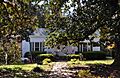
- The James S. Davis House
- The James H. Doan House
- The G.P. Hammerly House
- The J.C. Jourdan House
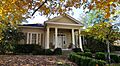
- The Merrill-Newhardt House
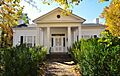
- The Reid House
- The Stone-Reid House
Each of these homes has its own story. They show us how people lived in Iuka many years ago. They also show different styles of architecture from the past.
Former Listing
One property, the R. D. Edwards House, was once on the National Register. It was listed in 1991 but was later removed in 2002. Sadly, this house was destroyed by a fire in 2001.
Images for kids
-
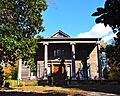
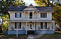
The R.C. Brinkley House.
-

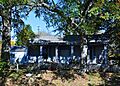
Buildings in the Central Iuka Historic District.
-
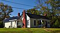
The J.M. Coman House.
-

The James S. Davis House.
-
The James H. Doan House.
-
The G.P. Hammerly House.
-
The J.C. Jourdan House.
-

The Merrill-Newhardt House.
-
The Reid House in Iuka.
-
The Stone-Reid House.


.JPG)

