
National Register of Historic Places listings in Todd County, Kentucky facts for kids

Have you ever wondered about really old and important buildings or places? In Todd County, Kentucky, there's a special list of them called the National Register of Historic Places. This list helps protect places that are super important to American history, architecture, archaeology, engineering, or culture. Think of it like a Hall of Fame for historic sites!
Todd County has 15 different places and areas on this special list. These places are found in towns like Elkton, Fairview, Allensville, Guthrie, and Trenton. Each one tells a unique story about the past.
Contents
- Exploring Historic Sites in Todd County
- Allensville Historic District
- Bethel Baptist Church
- Jefferson Davis Monument
- Edwards Hall
- Elkton Commercial Historic District
- Gray's Inn
- John Gray Springhouse
- Guthrie Historic District
- Hadden Site (15TO1)
- Idlewild
- McReynolds House
- Milliken Memorial Community House
- W.L. Reeves House
- Todd County Courthouse
- Woodstock
- Images for kids
Exploring Historic Sites in Todd County
Let's take a look at some of the amazing historic places you can find in Todd County:
Allensville Historic District
The Allensville Historic District is a special area in Allensville, Kentucky. It's not just one building, but a whole section of the town that has many old and important buildings. It was added to the list in 1988.
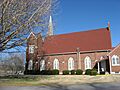
Bethel Baptist Church
The Bethel Baptist Church is located in Fairview, Kentucky. This church is a historic building that has been an important part of the community for a long time. It was added to the National Register in 1977.
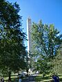
Jefferson Davis Monument
Also in Fairview, Kentucky, you'll find the Jefferson Davis Monument. This tall monument honors Jefferson Davis, who was born nearby. It's a very significant historical landmark in the area and was listed in 1973.
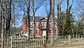
Edwards Hall
Edwards Hall is a historic building located in Elkton, Kentucky. This grand old hall has been around for many years and was recognized for its historical importance in 1974.
Elkton Commercial Historic District
Just like Allensville, Elkton, Kentucky also has a Commercial Historic District. This area includes many old shops and businesses that show what the town looked like long ago. It became a historic district in 1989.
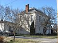
Gray's Inn
In Guthrie, Kentucky, you can find Gray's Inn. This historic inn likely served as a place for travelers to stay many years ago. It was added to the National Register in 2004.
John Gray Springhouse
The John Gray Springhouse is another historic spot near Elkton, Kentucky. A springhouse was a small building built over a natural spring, used to keep food cool before refrigerators existed. This one was listed in 1987.
Guthrie Historic District
The town of Guthrie, Kentucky has its own Historic District. This area contains many buildings that show the history and development of Guthrie. It was added to the list in 2011.
Hadden Site (15TO1)
The Hadden Site (15TO1) is a special archaeological site near Elkton, Kentucky. This means it's a place where archaeologists have found clues about people who lived there a very long time ago. It was listed in 1985.
Idlewild
Idlewild is a historic property located southeast of Trenton, Kentucky. This old estate has a rich history and was added to the National Register in 1980.
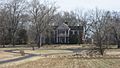
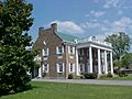
McReynolds House
The McReynolds House is another historic home in Elkton, Kentucky. Old houses like this often show us how people lived and what kind of architecture was popular in the past. It was listed in 1976.
Milliken Memorial Community House
The Milliken Memorial Community House is an important building in Elkton, Kentucky. Community houses often serve as gathering places for people in a town. This one was recognized in 1990.
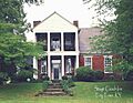
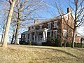
W.L. Reeves House
The W.L. Reeves House is another historic home in Elkton, Kentucky. It was added to the National Register in 1984, showing its importance to the area's history.
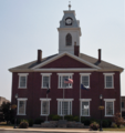
Todd County Courthouse
The Todd County Courthouse is a very important building in Elkton, Kentucky. Courthouses are where local government and legal matters happen. This historic building was listed in 1975.
Woodstock
Woodstock is a historic property located near Trenton, Kentucky. This site was added to the National Register in 2010, marking its historical value.
Images for kids
-
Bethel Baptist Church in Fairview, Kentucky.
-
The Jefferson Davis Monument in Fairview.
-
Edwards Hall in Elkton, Kentucky.
-
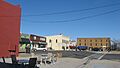
The northern side of the square in Elkton's Commercial Historic District.
-
Gray's Inn in Guthrie.
-
The John Gray Springhouse near Elkton.
-
The McReynolds House in Elkton.
-
The Milliken Memorial Community House in Elkton.
-
The W.L. Reeves House.
-
The Todd County Courthouse in Elkton.


