Allensville, Kentucky facts for kids
Quick facts for kids
Allensville, Kentucky
|
|
|---|---|

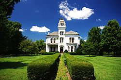
Hightower Place (Haddox House) in Allensville
|
|

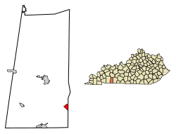
Location of Allensville in Todd County, Kentucky
|
|
| Country | United States |
| State | Kentucky |
| County | Todd |
| Area | |
| • Total | 1.15 sq mi (2.97 km2) |
| • Land | 1.14 sq mi (2.96 km2) |
| • Water | 0.00 sq mi (0.01 km2) |
| Elevation | 591 ft (180 m) |
| Population
(2020)
|
|
| • Total | 175 |
| • Density | 153.11/sq mi (59.10/km2) |
| Time zone | UTC-6 (Central (CST)) |
| • Summer (DST) | UTC-5 (CDT) |
| ZIP code |
42204
|
| Area code(s) | 270 |
| FIPS code | 21-01000 |
| GNIS feature ID | 0485878 |
Allensville is a small community in Todd County, Kentucky, in the United States. It is known as a census-designated place, which means it's a special area defined by the government for counting people. Allensville used to be a city, but its local government stopped working in the late 1970s and was officially dissolved in 2017. In 2020, about 175 people lived there.
Contents
History of Allensville
Allensville started as a small settlement in the early 1800s. It was first a busy spot where two important stagecoach roads crossed. These old roads are now similar to modern US 79 and KY 102. By the late 1830s, Allensville had a post office, two general stores, and a blacksmith shop. People believe the community was named after an early family who settled in the area.
The Railroad Era
A big change happened in 1860 when the L&N built a train station (depot) near Allensville. This was part of a new train line connecting Bowling Green, Kentucky, to Memphis, Tennessee. Because of the train, many businesses moved closer to the depot. After the American Civil War, Allensville officially became a city in 1867. It grew for many years as a key place for shipping farm products by train.
In 1897, something special happened in Allensville: Kentucky's first Rural Free Delivery service started there. This meant mail carriers began delivering mail directly to people's homes in the countryside, instead of them having to pick it up at the post office. In 1915, the L&N built an even bigger train station.
Changes Over Time
After World War II, Allensville began to slow down. More people started using cars instead of trains. The L&N closed its train station in 1947. By the 1970s, most big businesses had left, and the town's economy went back to being mostly about farming. The city government stopped working, and in 2017, the state court officially ended Allensville's status as a city.
In 1988, several old buildings and homes in Allensville were added to the National Register of Historic Places. This means they are important historical sites that should be protected.
Where is Allensville?
Allensville is located at 36°42′57″N 87°4′12″W / 36.71583°N 87.07000°W. It is mainly found along Kentucky Route 102, just east of where it crosses U.S. Route 79. The community is southeast of Elkton and southwest of Russellville. It is also just a few miles north of the border between Kentucky and Tennessee.
According to the United States Census Bureau, Allensville covers an area of about 1.1 square miles (2.9 square kilometers). This entire area is land.
People of Allensville
| Historical population | |||
|---|---|---|---|
| Census | Pop. | %± | |
| 1920 | 227 | — | |
| 2020 | 175 | — | |
| U.S. Decennial Census | |||
In 2000, there were 189 people living in Allensville. These people lived in 72 households, and 52 of those were families. The population density was about 173 people per square mile (67 people per square kilometer).
The people living in Allensville were a mix of different groups. About 20.6% of the population was under 18 years old. The median age was 40 years old, meaning half the people were younger than 40 and half were older.
See also
 In Spanish: Allensville (Kentucky) para niños
 | Charles R. Drew |
 | Benjamin Banneker |
 | Jane C. Wright |
 | Roger Arliner Young |

