
National Register of Historic Places listings in Transylvania County, North Carolina facts for kids

Imagine stepping back in time to explore old buildings and special places! In Transylvania County, North Carolina, there are many historic spots. These places are so important that they are listed on the National Register of Historic Places. This special list helps protect buildings, sites, and objects that tell us about the past. They might be old homes, schools, churches, or even entire neighborhoods. Each one has a unique story about how people lived and worked long ago.
Contents
Historic Places in Transylvania County
What is the National Register of Historic Places?
The National Register of Historic Places is the official list of the United States' historic places. It is part of a national program to coordinate and support public and private efforts to identify, evaluate, and protect America's historic and archaeological resources. When a place is added to this list, it means it is important to the history of the local area, the state, or even the whole country. It helps people understand and appreciate the past.
Exploring Historic Sites
Transylvania County is home to many fascinating historic places. Let's explore some of them!
The Biltmore Forest School
The Biltmore Forest School was listed on the National Register in 1974. It is located northwest of Brevard in the Pisgah National Forest. This school was very important for teaching people about forestry. It was one of the first schools in the United States to focus on managing forests. Imagine learning about trees and nature in such a beautiful setting!
.jpg)
Historic Homes in Brevard
Many old homes in Brevard are on the historic register. These houses show us how people lived in different times.
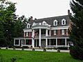
- The William Breese Jr. House at 401 East Main Street was listed in 1983.
- The Max and Claire Brombacher House at 571 East Main Street joined the list in 2001.
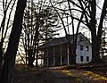
- The William Deaver House, north of Pisgah Forest, was listed in 1979. This house is a great example of early architecture in the area.
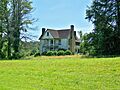
- The Flem Galloway House, near Calvert, was added in 1995.
- The Godfrey-Barnette House at 411 South Broad Street was listed in 1993.
- The William H. Grogan House at 24 Warren Lane was added in 2008.
- The Hanckel-Barclay House was listed in 1999.
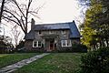
- The Royal and Louise Morrow House at 630 East Main Street was added in 2006.
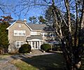
- The Charles E. Orr House at 269 East Main Street was also listed in 2006.
- The Silvermont estate on East Main Street was listed in 1981. It's a grand old home with a lot of history.
- The Dillard B. and Georgia Sewell House near Penrose was listed in 2015.
Important Buildings and Churches
Not just homes, but other important buildings and even parts of towns are recognized.
- The Brevard College Stone Fence and Gate was listed in 1993. This stone fence and gate are a unique part of the college's history.

- The Lake Toxaway Methodist Church was listed in 1994. This church has been a center for the community for many years.

- The McMinn Building at 2-6 West Main Street in Brevard was listed in 1994. This building is an important part of the town's downtown area.

- St. Philip's Episcopal Church at 317 East Main Street was listed in 1997. It's a beautiful church with a long history in Brevard.

- The Transylvania County Courthouse at North Broad and East Main Street was listed in 1979. This is where many important decisions for the county have been made over the years.

Historic Districts
Sometimes, not just one building, but a whole area is historic.
- The East Main Street Historic District in Brevard was listed in 2009. This district includes many historic buildings along East Main Street.
- The Main Street Historic District in Brevard was listed in 2002. This area is roughly bounded by Gaston, England, Probart, and Jordan Streets. It's a great place to see many old buildings together.
Other Unique Spots
- The E. M. Backus Lodge near Lake Toxaway was listed in 1988. This lodge extends into Jackson County.
- Hillmont on the west side of Lake Toxaway was listed in 1986.
- Morgan's Mill, southwest of Brevard, was listed in 1979. Mills like this were very important for grinding grain and other tasks in the past.
These historic places help us remember and learn about the past of Transylvania County. They are treasures that tell us stories about the people and events that shaped the area.
Images for kids
-
The William Deaver House.
-
The Flem Galloway House.
-
The Royal and Louise Morrow House.
-
The Charles E. Orr House.
-
The Silvermont estate.
-
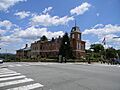
The Transylvania County Courthouse, part of the Main Street Historic District.


