
National Register of Historic Places listings in Uintah County, Utah facts for kids

Have you ever wondered about the really old and special places in your state? In Uintah County, Utah, there are many cool spots that are so important, they're listed on the National Register of Historic Places! This is like a special list kept by the United States government to protect amazing buildings, sites, and areas that tell us about history.
These places help us learn about the past, from ancient rock art to old homes and even famous dinosaur sites. Uintah County has 19 of these special places, and two of them are even called National Historic Landmarks, which means they are extra important to the history of the entire country!
Contents
Cool Historic Places in Uintah County, Utah
Historic Buildings in Vernal
Many of Uintah County's historic places are found in the city of Vernal. These buildings show us what life was like long ago.
Bank of Vernal
The Bank of Vernal is an old building right in the heart of Vernal. It was built a long time ago and shows the style of buildings from that era. It's located at 3 West Main Street.

Lewis Curry House
The Lewis Curry House is a historic home in Vernal. It's a great example of the kind of houses people lived in during the early 1900s. You can find it at 189 South Vernal Avenue.

Fenn-Bullock House
Another interesting old home in Vernal is the Fenn-Bullock House. It stands at 388 West 100 North and gives us a peek into the past architecture of the area.

Manfred and Ethel Martin House
The Manfred and Ethel Martin House is located at 163 North Vernal Avenue. This house is another example of the historic homes that make Vernal special.

St. Paul's Episcopal Church and Lodge
The St. Paul's Episcopal Church and Lodge is a beautiful old church building in Vernal. It's at 226 West Main Street and has been an important part of the community for many years.

Vernal Tithing Office
The Vernal Tithing Office is a unique historic building. It was used by members of The Church of Jesus Christ of Latter-day Saints to donate goods and money. It's found on the northwestern corner of 500 West and 200 South.

Washington School-Vernal LDS Relief Society Hall
This building, located at 252 North 500 West, has served two important purposes. It was once the Washington School and later became the Vernal LDS Relief Society Hall, showing how buildings can change uses over time.

Ancient Rock Art and Sites
Uintah County is home to incredible ancient rock art, called petroglyphs, left by people who lived here thousands of years ago.
Cockleburr Wash Petroglyphs
The Cockleburr Wash Petroglyphs are ancient carvings on rocks near Jensen. These amazing artworks give us clues about the lives and beliefs of early people.
Little Brush Creek Petroglyphs
Another site with fascinating rock art is the Little Brush Creek Petroglyphs near Vernal. These carvings are a window into the past, showing animals, people, and symbols.
McConkie Ranch Petroglyphs
The McConkie Ranch Petroglyphs are a very famous collection of rock art southeast of Dry Fork, near Vernal. You can see many different designs, including some very tall figures that look like "Bigfoot" or other mythical creatures.

Whiterocks Village Site
The Whiterocks Village Site near Whiterocks is an important archaeological spot. It tells us about the ancient villages and communities that once thrived in this area.
Dinosaur National Monument Sites
Dinosaur National Monument is a super cool place where you can see real dinosaur bones still in the rock! Several parts of the monument are historic places.
Earl Douglass Workshop-Laboratory
Earl Douglass was a paleontologist, a scientist who studies fossils. He discovered many dinosaur bones here. His Workshop-Laboratory was where he worked on these amazing finds. It's located along U.S. Route 40 within Dinosaur National Monument.

Josie Bassett Morris Ranch Complex
Josie Bassett Morris was a pioneer woman who lived in a remote part of the monument. Her Ranch Complex shows how people lived off the land in the early 1900s. It's also along U.S. Route 40.

Quarry Visitor Center
The Quarry Visitor Center at Dinosaur National Monument is a National Historic Landmark. This means it's super important to the history of the whole country! It's where you can see the famous "Wall of Bones" with hundreds of dinosaur fossils. It's also along U.S. Route 40.

Other Important Historic Places
Carter Road
Carter Road is a historic road located in the Ashley National Forest. Roads might not seem exciting, but this one tells a story about how people traveled and explored the area long ago.
Desolation Canyon
Desolation Canyon is a huge, wild canyon along the Green River. It's so special that it's a National Historic Landmark! It's known for its amazing natural beauty and its history as a route for explorers and river runners. It stretches across several counties, including Uintah County.

Images for kids
-

Some historic sites have restricted addresses to protect them.
-
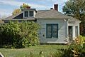
The Gibson-Sowards House in Vernal.
-
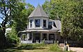
The William and Emily Siddoway House.
-
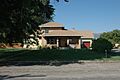
The Francis 'Frank' and Eunice Smith House.


