
National Register of Historic Places listings in Valley County, Montana facts for kids

Welcome to Valley County, Montana! This area is home to some really cool places that are super important to history. These special spots are listed on something called the National Register of Historic Places. Think of it like a special list of buildings, areas, or objects across the United States that are worth protecting because they tell us a lot about the past.
In Valley County, there are 13 different places that have made it onto this important list. These places include old buildings, a huge dam, and even a historic neighborhood. They help us understand what life was like long ago and how the area grew. You can even find some of these places on a map using their exact locations!
Contents
Historic Places in Valley County
Many of the historic places in Valley County are found in or near the town of Fort Peck. This town is famous for its giant dam, which was a huge project during the 1930s. Other important sites are in Glasgow and Nashua.
Fort Peck's Historic Buildings
The town of Fort Peck has several buildings that are recognized for their history, mostly built during the construction of the Fort Peck Dam.
Administration Building
- The Administration Building in Fort Peck is located on East Kansas Avenue.
- It was added to the National Register on August 13, 1986.
- This building likely served as the main office for managing the massive dam project.
Employee's Hotel and Garage
- The Employee's Hotel and Garage is on South Missouri Avenue in Fort Peck.
- It was also listed on August 13, 1986.
- This building probably housed many of the workers who came to Fort Peck to build the dam.
Fort Peck Theatre
- The Fort Peck Theatre is a well-known landmark on Missouri Avenue.
- It joined the National Register on June 27, 1983.
- This theater was a popular spot for entertainment for the dam workers and their families.
Garage and Fire Station
- The Garage and Fire Station in Fort Peck is on Gasconade Street.
- It was added to the list on August 13, 1986.
- This building was important for keeping the town safe and running smoothly.
Hospital
- The Hospital in Fort Peck is located on South Platte Street.
- It was listed on August 13, 1986.
- This hospital provided medical care for the thousands of people who lived and worked in Fort Peck during the dam's construction.
Recreation Hall
- The Recreation Hall in Fort Peck is another historic spot on Missouri Avenue.
- It was added to the National Register on August 13, 1986.
- This hall was likely a place where people could relax and have fun after a long day of work.
Fort Peck Original Houses Historic District
- The Fort Peck Original Houses Historic District includes homes on East Kansas Avenue.
- This district was recognized on August 13, 1986.
- It's a group of original houses that show what the living areas were like for the people who built the Fort Peck Dam.
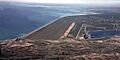
The Mighty Fort Peck Dam
- The Fort Peck Dam itself is a huge and important structure on the Missouri River.
- It was listed on the National Register on August 13, 1986.
- This dam is one of the largest earth-filled dams in the world and was a major project during the Great Depression. It created Fort Peck Lake, which is a popular spot for fishing and boating today.
Historic Sites in Glasgow
The city of Glasgow also has several buildings that are important to its history.
First National Bank of Glasgow
- The First National Bank of Glasgow is located at 110 5th Street, South.
- It was added to the National Register on June 27, 2002.
- This building is a reminder of Glasgow's early days and its economic growth.
Glasgow Army Airfield Norden Bombsight Storage Vault
- This unique vault is about half a mile north of Glasgow.
- It was listed on November 18, 2011.
- This vault was used to store special equipment called Norden bombsights during World War II, which were important for accurate bombing.
Rundle Building
- The Rundle Building is at 208 5th Street, South, in Glasgow.
- It joined the National Register on November 29, 2006.
- This building is another example of the historic architecture in Glasgow.
US Post Office and Courthouse - Glasgow Main
- This building is located at 605 2nd Avenue, South, in Glasgow.
- It was listed on March 21, 1986.
- It served as both a post office and a courthouse, playing a central role in the community's daily life and legal system.
Charles C. Sargent House in Nashua
- The Charles C. Sargent House is at 615 Front Street in Nashua.
- It was added to the National Register on July 8, 1982.
- This house is a historic home that tells us about the people and families who lived in Nashua long ago.
These historic places in Valley County help us learn about the past and understand how these communities developed over time. They are important parts of Montana's heritage!
| Name on the Register | Image | Date listed | Location | City or town | Description | |
|---|---|---|---|---|---|---|
| 1 | Administration Building |
(#86002058) |
E. Kansas Ave. 48°00′36″N 106°26′41″W / 48.01°N 106.444722°W |
Fort Peck | ||
| 2 | Employee's Hotel and Garage |
(#86002060) |
S. Missouri Ave. 48°00′32″N 106°26′47″W / 48.008889°N 106.446389°W |
Fort Peck | ||
| 3 | First National Bank of Glasgow |
 |
(#02000698) |
110 5th St., S. 48°11′40″N 106°38′07″W / 48.194444°N 106.635278°W |
Glasgow | |
| 4 | Fort Peck Dam |
_1986_01.jpg) |
(#86002061) |
On the Missouri River 48°00′17″N 106°25′10″W / 48.004722°N 106.419444°W |
Fort Peck | |
| 5 | Fort Peck Original Houses Historic District |
(#86002067) |
1101-1112 E. Kansas Ave. 48°00′40″N 106°26′47″W / 48.011111°N 106.446389°W |
Fort Peck | ||
| 6 | Fort Peck Theatre |
(#83001077) |
Missouri Ave. 48°00′27″N 106°27′00″W / 48.0075°N 106.45°W |
Fort Peck | ||
| 7 | Garage and Fire Station |
(#86002063) |
Gasconade St. 48°00′29″N 106°26′51″W / 48.008056°N 106.4475°W |
Fort Peck | ||
| 8 | Glasgow Army Airfield Norden Bombsight Storage Vault |
(#11000824) |
0.5 miles (0.80 km) north of Glasgow 48°13′13″N 106°36′33″W / 48.220406°N 106.609103°W |
Glasgow vicinity | ||
| 9 | Hospital |
(#86002054) |
S. Platte St. 48°00′28″N 106°26′40″W / 48.007778°N 106.444444°W |
Fort Peck | ||
| 10 | Recreation Hall |
(#86002066) |
Missouri Ave. 48°00′20″N 106°27′01″W / 48.005556°N 106.450278°W |
Fort Peck | ||
| 11 | Rundle Building |
 |
(#06001092) |
208 5th St., S. 48°11′38″N 106°38′13″W / 48.193889°N 106.636944°W |
Glasgow | |
| 12 | Charles C. Sargent House |
(#82003180) |
615 Front St. 48°07′56″N 106°21′17″W / 48.132222°N 106.354722°W |
Nashua | ||
| 13 | US Post Office and Courthouse-Glasgow Main |
_-_Valley_County,_Montana.png) |
(#86000679) |
605 2nd Ave., S. 48°11′40″N 106°38′18″W / 48.194444°N 106.638333°W |
Glasgow |
Images for kids
-
The impressive Fort Peck Dam.
