Fort Peck Lake facts for kids
Quick facts for kids Fort Peck Lake |
|
|---|---|

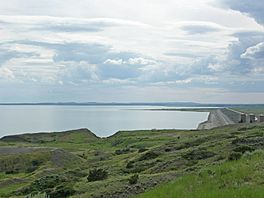
The lake seen from the Lewis and Clark Overlook east of the dam
|
|
| Location | |
| Coordinates | 47°46′41″N 106°40′53″W / 47.77806°N 106.68139°W |
| Lake type | Reservoir |
| Primary inflows | Missouri River, Musselshell River, Fourchette Creek, Dry Creek |
| Primary outflows | Missouri River |
| Catchment area | 57,500 sq mi (149,000 km2) |
| Max. length | 134 mi (216 km) |
| Surface area | 245,000 acres (99,000 ha) |
| Average depth | 76.3 ft (23.3 m) |
| Max. depth | 220 ft (67 m) |
| Water volume | 18,687,731 acre⋅ft (23.050977 km3) |
| Surface elevation | 2,250 feet (690 m) |
| Frozen | Winter |
| Islands | York Island, others unnamed |
| Settlements | Fort Peck |
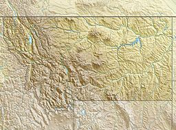
Fort Peck Lake, also called Lake Fort Peck, is a huge reservoir (a man-made lake) in Montana. It was created by the Fort Peck Dam on the Missouri River. This large lake is in the eastern prairie area of Montana. It is about 140 miles (230 km) east of Great Falls and 120 miles (190 km) north of Billings. The lake stretches across parts of six different counties.
Contents
Building Fort Peck Lake
The Fort Peck Dam and its lake were built in the 1930s. The main goal was to help boats travel better on the Missouri River. The dam would release enough water to keep a deep and wide channel for ships. This channel went from Sioux City, Iowa, all the way to where the Missouri River joins the Mississippi River.
Why the Dam Was Built
Building the dam was a big project by the U.S. Army Corps of Engineers. Work started in 1933 and finished in 1940. Water began to fill the lake in 1937. The lake reached its full size for the first time in 1947.
After a big flood on the Missouri River in 1943, the government decided to build more dams. This plan was called the Pick-Sloan Plan. It aimed to build a series of dams and lakes along the Missouri River and its smaller rivers. These dams would help control floods and manage water for other uses.
Size and Features of Fort Peck Lake
Fort Peck Lake is one of the biggest artificial lakes in the United States. When it is full, it holds about 18,700,000 acre-feet (23.1 km3) of water. This makes it the fifth largest artificial lake in the country by volume.
How Big Is the Lake?
The lake stretches for about 134 miles (216 km) through central Montana. Its shoreline is very twisty with many inlets. The total length of the shoreline is an amazing 1,520 miles (2,450 km). This is longer than the entire coast of California!
Besides the Missouri River, several smaller rivers and creeks feed into the lake. These include the Musselshell River, Fourchette Creek, and Dry Creek. Dry Creek forms the longest arm of the lake, reaching about 30 miles (48 km) to the south. The lake covers an area of 245,000 acres (99,000 ha). This makes it the largest lake in Montana by surface area. However, Flathead Lake holds more water because it is much deeper.
Fun and Nature at the Lake
Fort Peck Lake is a popular spot for visitors. There are 27 special places along its shores where people can enjoy outdoor activities.
Charles M. Russell National Wildlife Refuge
Almost the entire area around the lake is part of the Charles M. Russell National Wildlife Refuge. This huge wildlife refuge covers about 1,719 square miles (4,450 km2). It helps protect the beautiful prairie and hill country around the lake. This area is home to many different kinds of wildlife.
 | Laphonza Butler |
 | Daisy Bates |
 | Elizabeth Piper Ensley |


