
National Register of Historic Places listings in Walworth County, South Dakota facts for kids

This article is about the special places in Walworth County, South Dakota that are listed on the National Register of Historic Places. The National Register is like a special list kept by the United States government. It helps protect important buildings, sites, and objects that have a lot of history or are special in some way.
When a place is on this list, it means it's recognized for its historical or architectural importance. Walworth County has 13 places that are on this important list. These places help us learn about the past and understand how people lived and worked long ago in South Dakota.
Contents
Historic Buildings in Mobridge
Mobridge, South Dakota is home to several buildings that are recognized for their history. These places show us what life was like in the past.
Brown Palace Hotel
The Brown Palace Hotel is located at 301 Main Street. It was added to the National Register on January 27, 1983. Hotels like this were important places for travelers and community events many years ago.
A. H. Brown Public Library
The A. H. Brown Public Library is on North Main Street. It joined the list on December 22, 1978. Libraries are important for learning and community life, and this one has a long history in Mobridge.
Brown-Evans House
The Brown-Evans House is a historic home at 405 1st Avenue West. It was added to the National Register on June 21, 1990. Old houses like this can tell us about how families lived and the styles of buildings from different times.
Mobridge Auditorium
The Mobridge Auditorium at 212 Main Street became a historic place on May 23, 1986. Auditoriums are often used for performances, meetings, and other community gatherings, making them important centers for town life.
Mobridge Masonic Temple
The Mobridge Masonic Temple is found at 6th and Main Streets. It was listed on March 25, 1977. Masonic Temples are buildings used by a group called the Masons, who have a long history of community involvement.
Historic Sites and Buildings Near Mobridge
Some important historic places are found just outside the main town of Mobridge.
Gravel Pit Site (39WW203)
The Gravel Pit Site (39WW203) was added to the National Register on April 3, 1986. This site is restricted, meaning its exact location isn't shared publicly. Places like this are often archaeological sites where scientists find old tools or remains from people who lived there thousands of years ago.
Johnson Barn
The Johnson Barn is located about 4 miles west-northwest of Glenham, South Dakota. It was listed on August 30, 2005. Old barns are important parts of farming history and show how agriculture developed in the area.
Historic Places in Java
The town of Java, South Dakota also has some interesting historic listings.
Java Depot
The Java Depot is located at the northwestern corner of Railway Avenue and Main Street. It was added to the National Register on June 6, 2001. Train depots were once very busy places, as they were where people and goods arrived and departed by train.
Wilhelm Moser House-Barn
The Wilhelm Moser House-Barn is located north of Java. It was listed on November 28, 1984. This type of building, where a house and barn are combined or very close, shows unique ways people lived and farmed in the past.
Jacob Ochszbner Sr. House
The Jacob Ochszbner Sr. House is also north of Java. It became a historic listing on August 13, 1984. This house is another example of the important homes and farms that shaped the region's history.
Historic Places in Selby
Selby, South Dakota is the county seat of Walworth County and has its own historic buildings.
Selby Opera House
The Selby Opera House at 3409 Main Street was listed on September 25, 1987. Opera houses were popular places for entertainment, plays, and community events in the late 1800s and early 1900s.
Walworth County Courthouse
The Walworth County Courthouse is located at 4304 4th Avenue. It was added to the National Register on June 3, 1999. Courthouses are important government buildings where laws are made and justice is carried out. They often have grand architecture.
Historic Places in Glenham
The town of Glenham, South Dakota also has a unique historic park.
Molstad Lake Park
Molstad Lake Park is about 1¾ miles north of US 12 on 293rd Avenue. It was listed on November 29, 2010. This park is special because it was built as part of the Federal Relief Construction programs. These programs helped people find work during tough economic times by building public projects like parks.
Images for kids
-
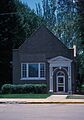
The A. H. Brown Public Library in Mobridge.
-
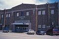
The Mobridge Auditorium, a historic community building.
-
The Mobridge Masonic Temple.


