
National Register of Historic Places listings in Washington County, Tennessee facts for kids

Have you ever wondered about old buildings or special places in your town? Some of them are so important that they are listed on the National Register of Historic Places! This is a special list in the United States that helps protect and celebrate places with interesting history.
In Washington County, Tennessee, there are many cool places on this list. These spots tell stories about the past, from old homes and farms to churches and even entire neighborhoods. Knowing about these places helps us understand how people lived long ago and what was important to them.
There are 37 places in Washington County that are on the National Register. One of them is even more special and is called a National Historic Landmark. This means it's super important to the history of the whole country! A few other places used to be on the list but have since been removed.
What is the National Register of Historic Places?
The National Register of Historic Places is like a special club for buildings, sites, and objects that are important in American history, architecture, archaeology, engineering, or culture. When a place is added to this list, it means it's recognized as a valuable part of our heritage.
Why are places listed?
Places get listed for many reasons. Maybe a famous person lived there, or an important event happened there. Sometimes, a building is listed because it shows a special way of building things from the past. Listing a place helps people know its value and encourages them to take care of it.
What does "Historic District" mean?
Sometimes, it's not just one building but a whole area that's historic. This is called a "Historic District." It means many buildings in that area together tell a story about the past. For example, a district might show how a town grew over time.
Historic Places in Washington County
Washington County has a rich history, and many of its special places are on the National Register. Let's look at some examples of the types of places you might find!
Homes and Farms
Many old homes and farms are listed because they show how people lived in the past. These can be simple farmhouses or grander homes.
- Aquone: This house in Johnson City is a historic home.
- Adam Alexander Broyles House: Located near Limestone, this house tells a story of early settlers.
- Isaac Cooper House: Another historic home in Limestone.
- DeVault Tavern: West of Jonesborough, this old tavern was a place where travelers could stop.
- Valentine DeVault House: A historic home north of Johnson City.
- Embree House: Found southwest of Telford.
- Col. George Gillespie House: Near Limestone, this house belonged to an important person.
- Isaac Hammer House: North of Johnson City.
- Henry Hoss House: In Jonesborough.
- Martin Kitzmiller House: Located in Gray.
- Peter Range Stone House: A unique stone house in Johnson City.
- Robin's Roost: Another historic spot in Johnson City.
- Shelbridge: In Johnson City.
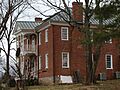
- Thomas Telford House: Near Limestone, built around 1815.
- Tipton-Haynes State Historic Site: Southeast of Johnson City, this site includes the historic Tipton-Haynes House.
Mills and Businesses
Old mills and business buildings are also important. They show how people worked and traded.
- Bashor Mill: Northeast of Johnson City, this mill was likely important for grinding grain.
- Dungan's Mill and Stone House: Another mill northeast of Johnson City.
- Carolina, Clinchfield & Ohio Railroad Station and Depot: This old train station in Johnson City was a busy place for travel and trade.
Churches and Community Places
Churches and other community buildings often hold special meaning for local history.
- St. Paul AME Zion Church: A historic church in Johnson City.
- Salem Presbyterian Church: In Limestone, this church was designed by a famous architect, A. Page Brown.
- Sulphur Springs Methodist Campground: North of Jonesborough, this was a place for religious gatherings.
- Thankful Baptist Church: Another historic church in Johnson City.
Historic Districts and Areas
These are larger areas where many historic buildings are grouped together.
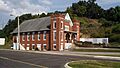
- Broylesville Historic District: This area near Washington College was developed in the late 1700s and early 1800s.
- Johnson City Commercial Historic District: This district includes old business streets in Johnson City.
- Johnson City Warehouse and Commerce Historic District: Another area in Johnson City with old warehouses and commercial buildings.
- Jonesborough Historic District: This is a large historic area in Jonesborough.
- Knob Creek Historic District: An area near Johnson City.
- Tree Streets Historic District: A historic neighborhood in Johnson City.
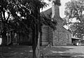
- Washington College Historic District: This district includes buildings from an early college established in 1780.
Other Interesting Sites
Some places are unique or have special archaeological importance.
- Johnson City Country Club: A historic country club in Johnson City.
- Montrose Court Apartments: Historic apartments in Johnson City.
- Mountain Branch, National Home for Disabled Volunteer Soldiers: This site in Johnson City is a National Historic Landmark. It was a home for soldiers who were disabled after serving their country.
- Plum Grove Archaeological Site: This site near Jonesborough is restricted because it contains important archaeological findings from the past.
Former Listings
Sometimes, a place might be removed from the National Register. This can happen if the building is changed too much or if it is no longer standing.
- Memorial Stadium: This stadium in Johnson City was once listed but has since been removed.
- Christopher Taylor House: An old house in Jonesborough that was also removed from the list.
Images for kids
-
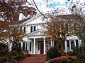
Aquone House
-
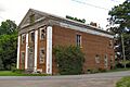
Broyles Mercantile building in the Broylesville Historic District
-
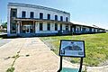
Carolina, Clinchfield & Ohio Railroad Station and Depot
-
DeVault Tavern
-
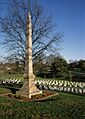
Brownlow Monument at the Mountain Branch, National Home for Disabled Volunteer Soldiers
-
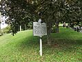
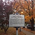
Historical Marker at Robin's Roost
-
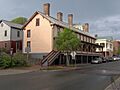
Chester Inn in the Jonesborough Historic District
-
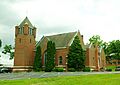
Salem Presbyterian Church
-
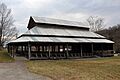
Sulphur Springs Methodist Campground
-
Thankful Baptist Church
-
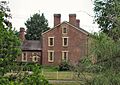
Thomas Telford House
-
Tipton-Haynes House
-
Tree Streets Historic District Marker
-
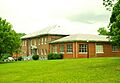
Carnegie Temple Hall at Washington College
-
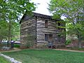
Christopher Taylor House (formerly listed)


.jpg)


