National Register of Historic Places listings in Webster County, Iowa facts for kids
Webster County, Iowa, is home to many special places that are listed on the National Register of Historic Places. This is a list of important buildings, parks, and other sites in the county that have been recognized for their history and unique features. These places are protected to make sure they last for a long time, so future generations can learn from them and enjoy them.
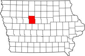
There are 14 places in Webster County that are officially listed on the National Register. You can even see where many of them are on a map!
Contents
Historic Places in Webster County
Webster County has many cool historic spots, especially in Fort Dodge and around the Des Moines River. Let's explore some of them!
Fort Dodge's Historic Gems
Fort Dodge, the biggest city in Webster County, has a lot of history packed into its streets. Many of its important buildings and areas are on the National Register.
Religious and Community Buildings
- Corpus Christi Church
This beautiful church is located at 416 North 8th Street. It was added to the National Register in 1976. Churches often play a big role in a community's history, and Corpus Christi is a great example of that in Fort Dodge.
- First National Bank Building
Found at 629 Central Avenue, this building became historic in 2003. Old bank buildings often show us what architecture and business were like in the past.
- Wahkonsa Hotel
The Wahkonsa Hotel, at 927 Central Avenue, joined the list in 2008. Hotels like this were once busy hubs for travelers and local events, and they tell stories of how people lived and visited in earlier times.
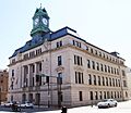
- Webster County Courthouse
The courthouse, located at 701 Central Avenue, was added to the Register in 1981. Courthouses are usually very important buildings in a county, where many official decisions and legal matters happen.
Schools and Education
- Fort Dodge Junior High School
This school building at 416 South 10th Street was recognized in 2015. Schools are important parts of a community's history, showing how education has changed over the years.
- Fort Dodge Senior High School
The high school building at 1015 5th Avenue North also became historic in 2015. It's cool to think about all the students who have walked through its halls over many decades!
Historic Districts and Areas
- Fort Dodge Downtown Historic District
This large area includes 1st Avenue North, Central Avenue, and 1st Avenue South, stretching from 3rd Street to 12th Street. It was listed in 2010. A historic district means that many buildings in that area together tell an important story about the past.
- Oak Hill Historic District
This district covers the area between 8th and 12th Streets and 2nd and 3rd Avenues. It was added to the Register in 1977. Historic neighborhoods like Oak Hill show us how people lived and what homes looked like a long time ago.
- Oakland Cemetery
Located at 1600 North 15th Street, this cemetery was recognized in 2000. Cemeteries can be historic places because they contain old monuments and tell us about the people who lived in the area in the past.
Other Notable Fort Dodge Sites
- Lorenzo S. Coffin Burial Plot
This special burial plot is located northwest of Fort Dodge, near Iowa Highway 7. It was listed in 1977. Lorenzo S. Coffin was an important person in Iowa's history, known for his work in agriculture and social reform.
- Oleson Park Music Pavilion
You can find this pavilion at 1400 Oleson Park Avenue. It became a historic site in 2003. Music pavilions are often places where communities gathered for concerts and events, bringing people together.
- Vincent House
The Vincent House, at 824 3rd Avenue South, was added to the Register in 1973. Historic houses give us a glimpse into the lives of families from previous generations.
Nature and History at Dolliver Memorial State Park
Dolliver Memorial State Park is a beautiful natural area that also holds historical importance. It's located north of Iowa Highway 50 on the Des Moines River.
- Dolliver Memorial State Park, Entrance Area (Area A)
This part of the park was listed in 1990. It's often the first place visitors see, and it's recognized for its historical design and natural beauty.
- Dolliver Memorial State Park, Picnic, Hiking & Maintenance Area (Area B)
Also listed in 1990, this area is where people enjoy picnics, go hiking, and where the park's maintenance facilities are located. State parks often have structures built by groups like the Civilian Conservation Corps (CCC) during the Great Depression, which are now considered historic.
Former Listings
Sometimes, a place that was once on the National Register of Historic Places might be removed. This can happen if the building is changed too much, or if it is torn down. Here are two places in Fort Dodge that were once listed but are no longer on the Register:
- Illinois Central Freight House and Office Building-Fort Dodge
This building was located at the corner of 4th Street and 4th Avenue South. It was listed in 1990 but was removed in 2003.
- Illinois Central Passenger Depot--Fort Dodge
Also at the corner of 4th Street and 4th Avenue South, this passenger depot was listed in 1990 and delisted in 2003.
Images for kids


