
National Register of Historic Places listings in West and Southwest Baltimore facts for kids
The city of Baltimore, Maryland is a place full of history! Many of its important buildings, neighborhoods, and sites are listed on the National Register of Historic Places. This special list helps protect places that are important to American history, architecture, archaeology, engineering, or culture. When a place is on this list, it means it's recognized as a valuable part of our past.
Baltimore is unique because it's an "independent city." This means it's not part of Baltimore County, even though the county surrounds it. So, this list focuses only on the amazing historic places found right within Baltimore City!
Contents
What is the National Register of Historic Places?
The National Register of Historic Places is like a hall of fame for historic sites across the United States. It's managed by the National Park Service. When a building or area is added to the Register, it gets special recognition. This helps people understand why these places are important and encourages their preservation. It's a way to make sure future generations can also learn from and enjoy these historical treasures.
Exploring Baltimore's Historic Sites
Baltimore has many different types of places on the National Register. These include old schools, churches, homes, and even entire neighborhoods! Each one tells a unique story about the city's past.
Historic Homes and Buildings
Many individual buildings in Baltimore have been recognized for their historical importance.
Edgar Allan Poe House
One of the most famous homes on the list is the Edgar Allan Poe House. This small house at 203 Amity Street was once home to the famous writer Edgar Allan Poe. He lived here in the 1830s, and it's where he wrote some of his early works. It's a great place to visit if you want to learn more about his life!

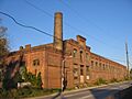
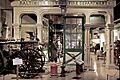
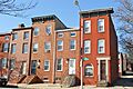
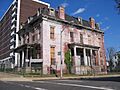
American Ice Company
The American Ice Company building, located at 2100 W. Franklin Street, is a cool example of an old industrial building. It shows how businesses operated in the past. It was added to the Register in 2013.

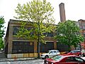
Engine House No. 8
Engine House No. 8 at 1027 W. Mulberry Street is an old fire station. These buildings are important because they show how cities grew and how essential services like fire protection developed over time. It was listed in 1995.

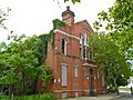
Hebrew Orphan Asylum
The Hebrew Orphan Asylum at 2700 Rayner Avenue was a place that cared for children who had lost their parents. It's a reminder of how communities supported each other in the past. It became a historic site in 2010.

Lion Brothers Company Building
The Lion Brothers Company Building at 875 Hollins Street is another example of a historic industrial building. It was added to the Register in 2006.

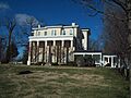
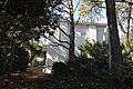
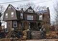
Schwartze Mansion and Sellers Mansion
The Schwartze Mansion (4206 Euclid Ave.) and Sellers Mansion (801 N. Arlington St.) are grand old homes that show the architectural styles and lives of wealthy families in Baltimore's past. The Schwartze Mansion was listed in 1985, and the Sellers Mansion in 2001.


Important Schools and Churches
Many educational and religious buildings are also recognized for their history.
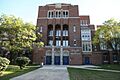
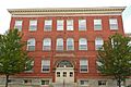
Frederick Douglass High School
Frederick Douglass High School at 1601 N. Calhoun Street is a very important school in Baltimore's history. It was named after the famous abolitionist Frederick Douglass. It was added to the Register in 1989.

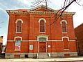
Public School No. 111
Public School No. 111 at N. Carrollton Avenue and Riggs Road is another historic school building. These old schools tell us about the history of education in the city. It was listed in 1979.

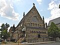
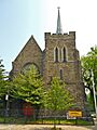
Cummins Memorial Church
Cummins Memorial Church at 1210 W. Lanvale Street is a historic church building. Churches often play a big role in community life and history. This church was listed in 1979.
_Ch_Lanvale_Baltimore.JPG)
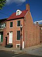
St. Luke's Church
St. Luke's Church at 217 N. Carey Street is another beautiful historic church, added to the Register in 1973.

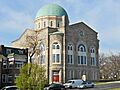
Shaarei Tfiloh Synagogue
The Shaarei Tfiloh Synagogue at 2001 Liberty Heights Avenue is a historic place of worship for the Jewish community. It was listed in 1996.

Historic Districts and Neighborhoods
Sometimes, not just one building, but an entire area or neighborhood is considered historically important. These are called "historic districts."
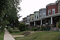
Edmondson Avenue Historic District
The Edmondson Avenue Historic District includes several streets and shows what a neighborhood looked like in the past. It was added to the Register in 2010.

Franklin Square Historic District
The Franklin Square Historic District is another neighborhood recognized for its historic buildings and layout. It was listed in 1982.

Franklintown Historic District
The Franklintown Historic District is a unique area that includes old mills and other historic structures, showing how early communities developed. It was added in 2001.

Hollins-Roundhouse Historic District
The Hollins-Roundhouse Historic District is important for its connection to Baltimore's industrial and railroad history. It was listed in 2009.

Old West Baltimore Historic District
The Old West Baltimore Historic District covers a large area and represents a significant part of the city's development and culture. It was added in 2004.

Windsor Hills Historic District
The Windsor Hills Historic District is another neighborhood that has kept its historic character, recognized in 2002.

Cemeteries and Hospitals
Even places like cemeteries and hospitals can be historically significant.
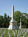
Baltimore National Cemetery
The Baltimore National Cemetery at 5501 Frederick Avenue is a burial ground for military veterans. It's a place of honor and remembrance, listed in 2016.

Loudon Park National Cemetery
Similar to the Baltimore National Cemetery, Loudon Park National Cemetery at 3445 Frederick Avenue is also a national cemetery, added to the Register in 1996.

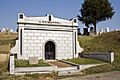
Weiskittel-Roehle Burial Vault
The Weiskittel-Roehle Burial Vault is a specific burial structure within Loudon Park Cemetery, recognized for its unique design and history in 1976.

James Lawrence Kernan Hospital
The James Lawrence Kernan Hospital at Windsor Mill Road and Forest Park Avenue is a historic hospital. Hospitals have played a big role in public health and medical advancements. It was listed in 1979.

Images for kids
-
The historic American Ice Company building.
-

Baltimore National Cemetery.
-
Cummins Memorial Church.
-
Frederick Douglass High School.
-
A view of the Edmondson Avenue Historic District.
-
Engine House No. 8, an old fire station.
-
A building within the Franklin Square Historic District.
-
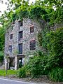
An old mill in the Franklintown Historic District.
-
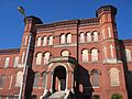
The former Hebrew Orphan Asylum.
-
A street view in the Hollins-Roundhouse Historic District.
-
James Lawrence Kernan Hospital.
-
The Lion Brothers Company Building.
-
Loudon Park National Cemetery.
-
A building in the Old West Baltimore Historic District.
-
The Edgar Allan Poe House, where the famous writer lived.
-
Public School No. 111.
-
St. Luke's Church.
-
The historic Schwartze Mansion.
-
The Sellers Mansion.
-
Shaarei Tfiloh Synagogue.
-
The Weiskittel-Roehle Burial Vault.
-
A street in the Windsor Hills Historic District.
