
National Register of Historic Places listings in Whitley County, Kentucky facts for kids

Welcome to Whitley County, Kentucky! This page is all about special places in the county that are listed on the National Register of Historic Places. This is an official list in the United States that helps protect important buildings, sites, and objects. These places are special because they tell us about history, architecture, or culture.
There are 13 different properties and areas in Whitley County that are on this important list. Each one has a unique story! You can even see some of these places on a map if their exact location is shared.
Contents
What is the National Register of Historic Places?
The National Register of Historic Places is like a hall of fame for buildings, structures, objects, sites, and districts that are important to American history. It's managed by the National Park Service. When a place is added to this list, it means it's recognized for its special value. This helps to save these places for future generations to enjoy and learn from.
Being on the list can also help protect these places from being torn down or changed too much. It encourages people to take care of them.
Historic Places in Whitley County
Whitley County has many interesting places that show its past. Let's explore some of them!
Ancient Sites
Bowman Site (15WH14)
- Location: Near Lot, Kentucky (exact address is kept private to protect the site).
- Listed: November 30, 1985
- About: This site is a "Mississippian mound." The Mississippian culture was a group of Native American people who lived in the eastern and central United States a long time ago. They often built large earth mounds for ceremonies or as burial sites. This mound helps us learn about the ancient people who lived in Kentucky.
Buildings in Corbin
Corbin is a city in Whitley County with several historic buildings.
Carnegie Library
- Location: East Center Street, Corbin
- Listed: March 28, 1986
- About: This library was built with money from Andrew Carnegie, a famous businessman who helped fund many libraries across the country. These "Carnegie Libraries" were important for spreading knowledge and education.
Corbin Bank Building
- Location: 101 Center Street, Corbin
- Listed: March 28, 1986
- About: This building was once a busy bank. It shows the style of architecture that was popular when it was built. Banks were very important for the growth of towns like Corbin.
First Christian Church
- Location: South Kentucky and West 1st Street, Corbin
- Listed: March 28, 1986
- About: Churches are often central to a community's history. This church building has been a place of worship and gathering for many years in Corbin.
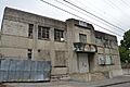
Mershon Building
- Location: East Center Street, Corbin
- Listed: March 28, 1986
- About: The Mershon Building is another historic structure in downtown Corbin. It likely housed businesses or offices, playing a role in the city's commercial life.
Louisville and Nashville Railroad Depot
- Location: Lynn Avenue, Corbin
- Listed: June 15, 1978
- About: Railroads were super important for travel and trade in the past. This depot was a train station where people would arrive and depart, and goods would be loaded and unloaded. It shows Corbin's history as a railroad town.
Historic Districts
Gordon Hill Road Historic District
- Location: 309-501 Gordon Hill Road, Corbin
- Listed: March 28, 1986
- About: A "historic district" is an area with several buildings or structures that are all important together. This district on Gordon Hill Road likely has homes or other buildings that show how Corbin grew and developed.
Structures in Corbin
East Main Street Bridge
- Location: Engineer Street and Lynn Camp Creek, Corbin
- Listed: March 28, 1986
- About: Bridges are important parts of a town's infrastructure. This bridge helped people and vehicles cross Lynn Camp Creek, connecting different parts of Corbin.
Buildings in Williamsburg
Williamsburg is the county seat of Whitley County and also has several historic sites.
Dr. Ancil Gatliff House
- Location: South 5th Street, Williamsburg
- Listed: August 11, 1980
- About: This house was once the home of Dr. Ancil Gatliff. Historic homes often show us how people lived in the past and the architectural styles of different eras.
J.B. Gatliff House
- Location: 10th and Main Streets, Williamsburg
- Listed: December 16, 1977
- About: Another historic home, the J.B. Gatliff House, tells us about the prominent families and the way homes were built in Williamsburg's history.
Lane Theater
- Location: 510 Main Street, Williamsburg
- Listed: November 26, 2004
- About: The Lane Theater was a place for entertainment, like movies or live shows. Theaters are important for the cultural life of a town and often have unique designs.
Williamsburg Armory
- Location: South 2nd Street, Williamsburg
- Listed: September 6, 2002
- About: An armory is a place where military equipment is stored, or where military reserves might train. This building played a role in the local community's connection to defense and public service.
Images for kids
-
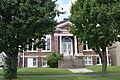
The historic Carnegie Library in Corbin.
-
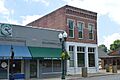
The old Corbin Bank Building.
-
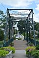
The East Main Street Bridge.
-
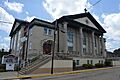
The First Christian Church building.
-

The Dr. Ancil Gatliff House.
-

The J.B. Gatliff House.
-
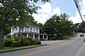
A view of the Gordon Hill Road Historic District.
-
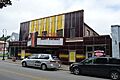
The Lane Theater in Williamsburg.
-
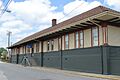
The Louisville and Nashville Railroad Depot.
-
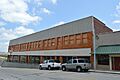
The Mershon Building in Corbin.
-
The Williamsburg Armory.


