
National Register of Historic Places listings in Wood County, West Virginia facts for kids

Hey everyone! Ever wonder about really old and special buildings or places in your community? Well, in Wood County, West Virginia, there's a list of amazing historic spots that are super important to our country's past. This list is called the National Register of Historic Places. It's like a special hall of fame for buildings, areas, and objects that have a lot of history.
This article will tell you about some of these cool places in Wood County, West Virginia. There are 47 places currently on this list, and a few others that were once on it but aren't anymore. Let's explore some of these historic treasures!
Contents
What is the National Register of Historic Places?
The National Register of Historic Places is the official list of the nation's historic places that are worth saving. It's part of a program by the United States government to help protect important historical and archaeological sites. When a place is added to the Register, it means it's recognized for its historical, architectural, or cultural importance. This can help protect it and sometimes even provide money for its care.
Cool Historic Places in Wood County
Wood County has many interesting places on the National Register. These include old homes, churches, public buildings, and even entire neighborhoods!
Historic Districts: Whole Neighborhoods with History
Sometimes, it's not just one building that's special, but a whole group of them! These are called historic districts. They are areas where many buildings together tell a story about the past.
- Avery Street Historic District: This area in Parkersburg is full of historic buildings. It was added to the list in 1986.
- Blennerhassett Island Historic District: This famous island in the Ohio River is a State Park! It's known for the historic Blennerhassett Mansion. It became a historic district way back in 1972.
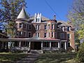
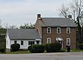
- Henderson Hall Historic District: Located near Williamstown, this district includes the historic Henderson Hall. It joined the list in 1986.
- Julia-Ann Square Historic District: This beautiful area in Parkersburg has many grand old homes. It was recognized in 1977.
- Parkersburg High School-Washington Avenue Historic District: This district includes the impressive Parkersburg High School and the surrounding area, added in 1992.
Important Buildings and Landmarks
Many individual buildings in Wood County are also on the National Register because of their unique history or architecture.
- Bethel AME Church: This church in Parkersburg was listed in 1998. Sadly, it was later taken down.
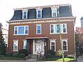
- W. H. Bickel Estate: This estate in Parkersburg is a significant historic property, added in 2004.
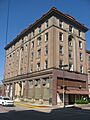
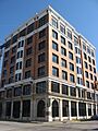
- Blennerhassett Hotel: A beautiful and historic hotel in Parkersburg, listed in 1982. It's still a popular place today!
- Carnegie Library: This library in Parkersburg was built with money from Andrew Carnegie, a famous businessman who helped build many libraries. It was listed in 1982.
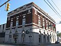
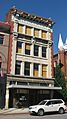
- Citizens National Bank: An important old bank building in Parkersburg, added in 1982.
- Cook House: This historic house in Parkersburg was listed in 1978.
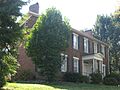
- Henry Cooper House: Another historic home in Parkersburg, added to the list in 1986.
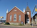
- First Baptist Church: This church in Parkersburg has been a part of the community for a long time, listed in 1982.
- First Presbyterian Church/Calvary Temple Evangelical Church: An old church building in Parkersburg, recognized in 1982.
- Fort Boreman: This historic fort overlooks the Little Kanawha River and Ohio River in Parkersburg. It was added to the Register in 2003. It played a role in history!
- Gould House/Greater Parkersburg Chamber of Commerce: This building in Parkersburg, now home to the Chamber of Commerce, was listed in 1982.
- Jackson Memorial Fountain: A historic fountain in Parkersburg, added in 1984.
- Henry Logan Memorial AME Church: This church in Parkersburg was listed in 1982.
- Masonic Temple: A significant building for the Masonic Lodge in Parkersburg, added in 1982.
- Mather Building/Franklin & DeHaven Jewelers: This building in Parkersburg, which housed a jewelry store, was listed in 1982.
- Dr. W. W. Monroe House: A historic house in Parkersburg, added in 2012.
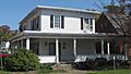
- George Neale Jr. House: This house in Parkersburg was listed in 1980.
- Oakland: A historic property in Parkersburg, added in 1979.
- Oeldorf Building/Wetherell's Jewelers: Another historic building in Parkersburg that housed a jewelry store, listed in 1982.
- Parkersburg Women's Club: This club building in Parkersburg was recognized in 1982.
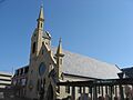
- St. Francis Xavier Church: A beautiful and historic church in Parkersburg, added in 1978.
- Sharon Lodge No. 28 IOOF: This lodge building in Parkersburg was listed in 1982.
- Sixth Street Railroad Bridge: This historic bridge in Parkersburg, which crosses into Ohio, was added in 1982.
- W.H. Smith Hardware Company Building: A historic hardware store building in Parkersburg, listed in 2003.
- Smoot Theater: This historic theater in Parkersburg is a great place to see shows and was listed in 1982.
- Tavenner House: A historic house in Parkersburg, added in 1982.
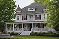
- Tomlinson Mansion: This grand mansion in Williamstown was listed in 1974.
- Trinity Episcopal Church Rectory: The rectory (a house for a priest) of the Trinity Episcopal Church in Parkersburg, listed in 1982.
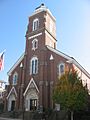
- Trinity Protestant Episcopal Church: The main church building of Trinity Episcopal Church in Parkersburg, also listed in 1982.
- Union Trust & Deposit Co./Union Trust National Bank: A historic bank building in Parkersburg, added in 1982.
- Windmill Quaker State: This unique windmill in Parkersburg was listed in 1982.
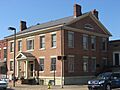
- Wood County Courthouse: The main courthouse for Wood County in Parkersburg, a very important building, listed in 1979.
Places No Longer on the List
Sometimes, a historic place might be removed from the National Register. This usually happens if the building is torn down or changed so much that it loses its historic look and feel. Here are a few places in Wood County that were once on the list but are not anymore:
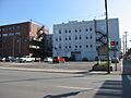
- Bethel AME Church (Parkersburg): Listed in 1998, but later demolished.
- Case House (Parkersburg): Listed in 1982, but later demolished.
- Elks Club (Parkersburg): Listed in 1982, but later demolished.
- Smith Building (Parkersburg): Listed in 1982, but later demolished.
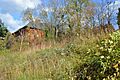
- Peter G. Van Winkle House (Parkersburg): Listed in 1982, but later demolished.
- Walton Wait House (Parkersburg): Listed in 1982, but later demolished.
- Chancellor Hardware (Parkersburg): Listed in 1982, removed in 1992 because it was demolished.
- Guaranty Building (Parkersburg): Listed in 1982, removed in 1992 because it was demolished.
- Parkersburg City Hall: Listed in 1979, removed in 1981 because it was demolished.
- Robb Apartments (Parkersburg): Listed in 1982, removed in 1987 because they were demolished.
It's important to remember that even if a building is no longer standing, its history still matters!
Images for kids
-
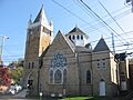
St. John's Lutheran Church, part of the Avery Street Historic District.
-
The site where Bethel AME Church once stood.
-
The W. H. Bickel Estate.
-
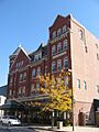
The historic Blennerhassett Hotel.
-
The Blennerhassett Mansion on Blennerhassett Island.
-
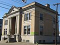
The Carnegie Library in Parkersburg.
-
The site where the Case House once stood.
-
The Citizens National Bank building.
-
The Cook House.
-
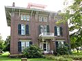
The Henry Cooper House.
-
The former Elks Club building.
-
The First Baptist Church.
-
The First Presbyterian Church.
-
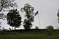
Fort Boreman overlooking the rivers.
-
The Gould House.
-
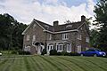
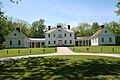
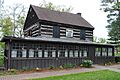
Henderson Hall.
-
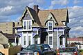
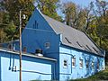
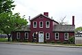
A historic house at 10th and Avery Streets.
-
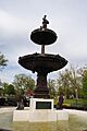
The Jackson Memorial Fountain.
-
The Peter Van Winkle House, part of the Julia-Ann Square Historic District.
-
The Henry Logan Memorial AME Church.
-
The Masonic Temple.
-
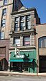
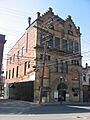
The Mather Building.
-
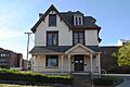
The Dr. W. W. Monroe House.
-
The George Neale Jr. House.
-

Oakland, also known as the Stephenson House.
-
The Oeldorf Building.
-
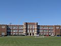
Parkersburg High School.
-
The Parkersburg Women's Club building.
-
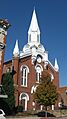
St. Francis Xavier Church.
-
Sharon Lodge No. 28 IOOF.
-
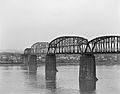
The Sixth Street Railroad Bridge.
-
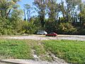
The site where the Smith Building once stood.
-
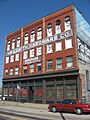
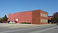
The W.H. Smith Hardware Company Building.
-
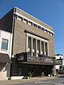
The Smoot Theater.
-
The Tavenner House.
-
The Tomlinson Mansion.
-
The Trinity Episcopal Church Rectory.
-
The Trinity Protestant Episcopal Church.
-
The Union Trust National Bank building.
-
The site where the Peter G. Van Winkle House once stood.
-
The site where the Walton Wait House once stood.
-
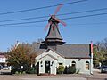
The Windmill Quaker State.
-
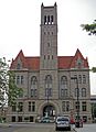
The Wood County Courthouse.


