
National Register of Historic Places listings in downtown Houston, Texas facts for kids
This is a list of special buildings and places in downtown Houston, Texas. These places are listed on the National Register of Historic Places. This means they are important for their history, architecture, or what happened there.
Downtown Houston is the area surrounded by big highways like Interstate 10, Interstate 45, and Interstate 69. You can see where these historic places are on a map by clicking "Map of all coordinates" if you see that option.
| downtown Houston - Houston Heights - inner Harris County - outer Harris County |
Historic Places in Downtown Houston
This section lists many of the cool and old buildings in downtown Houston that are on the National Register of Historic Places. Each one has a unique story!
Important Buildings and Churches
- 1884 Houston Cotton Exchange Building
- Address: 202 Travis St.
- Listed: May 6, 1971
- This building was once a busy place where cotton was traded.

- 500 Jefferson Building
- Address: 500 Jefferson St.
- Listed: March 6, 2019
- This is a modern building that is also considered historically important.

- Annunciation Church
- Address: 1618 Texas Ave.
- Listed: November 3, 1975
- This beautiful church has been a part of Houston's history for a long time.

- Antioch Missionary Baptist Church
- Address: 500 Clay St.
- Listed: December 22, 1976
- This church is very important in Houston's African American history.
.jpg)
- Battelstein's
- Address: 812 Main St.
- Listed: February 6, 2020
- This building was once a well-known department store.

- Beaconsfield
- Address: 1700 Main St.
- Listed: March 29, 1983
- This historic building stands out on Main Street.
- James Bute Company Warehouse
- Address: 711 William St.
- Listed: July 7, 1994
- This old warehouse was used by the James Bute Company.

- Christ Church
- Address: 1117 Texas Ave.
- Listed: June 15, 1979
- This is a historic church in the heart of downtown.
.jpg)
- City National Bank Building
- Address: 1001 McKinney Ave.
- Listed: April 3, 2000
- This building was once a major bank in the city.

- Arthur B. Cohn House
- Address: 900 block of Avenida De Las Americas
- Listed: November 7, 1985
- This historic house was moved from its original spot to save it.
.jpg)
- Downtown Houston Post Office, Processing and Distribution Center
- Address: 401 Franklin St.
- Listed: February 2, 2018
- This large building has served as Houston's main post office.
- W. L. Foley Building
- Address: 214-218 Travis St.
- Listed: October 11, 1978
- This building is an example of early Houston architecture.
.jpg)
- Gulf Building
- Address: 710-724 Main St.
- Listed: August 30, 1983
- This tall building was once the headquarters for the Gulf Oil Company.

- Houston Bar Center Building
- Address: 723 Main St.
- Listed: June 26, 2017
- This building is important to Houston's legal community.

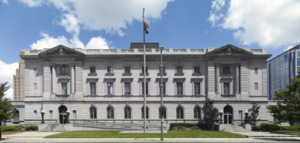
- Harris County Courthouse of 1910
- Address: 301 Fannin St.
- Listed: May 13, 1981
- This beautiful building served as the main courthouse for Harris County.

- Hogg Building
- Address: 401 Louisiana St.
- Listed: July 14, 1978
- Also known as Hogg Palace, this building has a unique design.

- Houston City Hall
- Address: 901 Bagby St.
- Listed: September 18, 1990
- This is where Houston's city government works.

- Houston Post-Dispatch Building
- Address: 609 Fannin
- Listed: February 14, 2002
- This building was home to a major Houston newspaper.
.jpg)
- Humble Oil Building
- Address: 1212 Main St.
- Listed: January 27, 1999
- This skyscraper was built for the Humble Oil company.

- Julia Ideson Building
- Address: 500 McKinney St.
- Listed: November 23, 1977
- This is a beautiful old library building.

- Kellum-Noble House
- Address: 212 Dallas St.
- Listed: April 3, 1975
- This is one of the oldest houses in Houston.
.jpg)
- Kennedy Bakery
- Address: 813 Congress St.
- Listed: July 27, 1979
- This building was once a famous bakery.

- Kress Building
- Address: 705 Main St.
- Listed: October 4, 2002
- This building was part of the S. H. Kress and Co. chain of stores.

- Main Street/Market Square Historic District
- Address: Around Buffalo Bayou, Fannin, Texas, and Milam streets
- Listed: July 18, 1983
- This is a whole area, not just one building, that is important for its history.
.jpg)
- McKee Street Bridge
- Address: McKee St. and Buffalo Bayou
- Listed: September 3, 2002
- This old bridge crosses over Buffalo Bayou.

- Melrose Building
- Address: 1121 Walker
- Listed: September 17, 2014
- This building is known for its unique design.

- Merchants and Manufacturers Building
- Address: University of Houston–Downtown, 1 Main St.
- Listed: September 17, 1980
- This building is now part of the University of Houston–Downtown.
_Houston.jpg)
- National Biscuit Company Building
- Address: 15 N. Chenevert
- Listed: February 20, 1998
- This building was once a factory for the National Biscuit Company (Nabisco).
_--_Houston.jpg)
- Old Houston National Bank
- Address: 202 Main St.
- Listed: July 17, 1975
- This building used to be a bank and is now the Islamic Da’wah Center.

- Palace Hotel
- Address: 216 La Branch
- Listed: September 13, 2006
- This building was once a grand hotel.

- Paul Building
- Address: 1018 Preston Ave.
- Listed: April 6, 1979
- The Paul Building is another historic structure in downtown.
.jpg)
- Petroleum Building
- Address: 1314 Texas Avenue
- Listed: August 8, 2019
- This building was important for Houston's oil industry.
.jpg)
- Rice Hotel
- Address: Main St. and Texas Ave.
- Listed: June 23, 1978
- This famous hotel has hosted many important events and people.
.jpg)
- Sam Houston Hotel
- Address: 1117 Prairie St.
- Listed: April 17, 2002
- This hotel is now known as Alden Houston.
_(HDR).jpg)
- San Jacinto Street Bridge over Buffalo Bayou
- Address: San Jacinto St. at Buffalo Bayou
- Listed: October 16, 2007
- This bridge is another historic crossing over Buffalo Bayou.

- Scanlan Building
- Address: 405 Main St.
- Listed: May 23, 1980
- The Scanlan Building is a notable part of Houston's downtown skyline.

- South Texas National Bank
- Address: 215 Main St.
- Listed: December 8, 1978
- This bank building was unfortunately taken down in 1983.
- Southwestern Bell Capitol Main Office
- Address: 1121 Capitol St. & 1114 Texas Ave.
- Listed: August 25, 2016
- This building was once the main office for Southwestern Bell.

- State National Bank Building
- Address: 412 Main St.
- Listed: August 11, 1982
- This building also served as a bank in Houston's past.
.jpg)
- Stowers Building
- Address: 820 Fannin
- Listed: June 3, 2015
- The Stowers Building is a historic landmark.

- Sweeney, Coombs & Fredericks Building
- Address: 301 Main St.
- Listed: June 20, 1974
- This building is named after its original occupants.

- Texas Company Building
- Address: 1111 Rusk
- Listed: April 2, 2003
- This building was important to the Texas Company.

- Texas State Hotel
- Address: 720 Fannin
- Listed: January 10, 2008
- This building was once a busy hotel.

- U.S. Customhouse
- Address: 701 San Jacinto St.
- Listed: August 28, 1974
- This building was where customs duties were collected.
- Union Station
- Address: 501 Crawford St.
- Listed: November 10, 1977
- This was once a major train station in Houston.

- Willow Street Pump Station
- Address: University of Houston–Downtown, 811 N. San Jacinto St.
- Listed: May 27, 2004
- This old pump station is now part of the University of Houston–Downtown.
_Houston.jpg)
Former Historic Places
Sometimes, buildings that were once on the National Register of Historic Places are removed from the list. This can happen if they are torn down or changed too much.
- Macatee Building
- Address: 101 Austin St.
- Listed: May 24, 1984
- Removed: April 15, 1991
.jpg)
- Pillot Building
- Address: 1006 Congress Ave.
- Listed: June 13, 1974
- Removed: October 28, 1994
- This building collapsed in 1988, but it was rebuilt using some of the original parts!

