
National Register of Historic Places listings in Harris County, Texas facts for kids

Harris County, Texas, is home to many amazing places that are important to history! These special spots are listed on the National Register of Historic Places. This list helps protect buildings, areas, and objects that tell us about the past of Harris County and the United States. Think of it like a Hall of Fame for historic sites!
Contents
Cool Historic Places in Harris County
Space Exploration Landmarks
Harris County played a huge role in space travel! You can find some incredible places connected to NASA's missions here.
Apollo Mission Control Center
The Apollo Mission Control Center at the Lyndon B. Johnson Space Center in Houston is where NASA managed all the famous Apollo missions, including the moon landings! Imagine the excitement and tension as scientists and engineers worked here to guide astronauts to the Moon and back. It was added to the National Register in 1985.
116.jpg)
Saturn V Launch Vehicle
Also at the Johnson Space Center, you can see a real Saturn V rocket! This giant rocket was used to launch astronauts to the Moon. It's an incredible sight and reminds us of the amazing engineering and bravery involved in space exploration. It was listed in 2003.

Space Environment Simulation Laboratory
This lab, also at the Johnson Space Center, was built to test spacecraft and equipment in conditions similar to space. It helped engineers make sure everything would work correctly before astronauts went into orbit. It was added to the Register in 1985.
.jpg)
Historic Buildings and Neighborhoods
Many old buildings and entire neighborhoods in Harris County have been preserved because they show us how people lived and worked long ago.
The Astrodome
Known as the "Eighth Wonder of the World" when it opened, The Astrodome in Houston was the first multi-purpose domed sports stadium in the world! It hosted baseball, football, concerts, and more. It was a huge step forward in stadium design and was added to the Register in 2014.

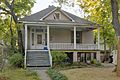
Old Sixth Ward Historic District
The Old Sixth Ward Historic District in Houston is one of the oldest neighborhoods in the city. It has many beautiful Victorian-style homes built in the late 1800s. Walking through this area feels like stepping back in time! It became a historic district in 1978.
.jpg)
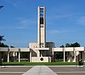
Houston City Hall
The Houston City Hall building, completed in 1939, is where the city's government works. It's a grand building with a classic design that represents the city's growth and importance. It was listed in 1990.

Houston Public Library (Heights Branch)
The Houston Public Library branch in the Heights neighborhood is a beautiful old building that has served the community for many years. Libraries are important places for learning and connecting, and this one has a special history. It was added to the Register in 1984.

Houston Negro Hospital
The Houston Negro Hospital was very important because it was the first non-profit hospital in Houston for African Americans. It provided crucial healthcare services when other hospitals were segregated. It was listed in 1982.
.jpg)
Kellum-Noble House
The Kellum-Noble House in downtown Houston is the oldest surviving building in the city! It was built in 1847 and shows us what early Houston homes looked like. It's a true piece of Houston's beginnings. It was added to the Register in 1975.
.jpg)
Main Street/Market Square Historic District
This busy area in downtown Houston is filled with historic buildings that tell the story of the city's business and social life. It's where many important events happened as Houston grew. This district was listed in 1983.
.jpg)
Wunsche Bros. Saloon and Hotel
Located in Spring, Texas, the Wunsche Bros. Saloon and Hotel is a cool old building that used to be a popular spot for travelers and locals. It gives us a peek into what life was like in a small Texas town over a hundred years ago. It was listed in 1984.

Important Historical Sites
San Jacinto Battlefield
The San Jacinto Battlefield is a very important historical site located east of Houston. This is where the Battle of San Jacinto took place in 1836, which led to Texas winning its independence from Mexico. It's a place where you can learn about a key moment in Texas history. It was listed in 1966.

USS Texas
The U.S.S. TEXAS is a famous battleship that fought in both World War I and World War II. It's now a museum ship located near the San Jacinto Battlefield. It's an amazing chance to see a real battleship up close and learn about naval history. It was added to the Register in 1976.

Unique and Artistic Places
Rothko Chapel
The Rothko Chapel in Houston is a special place for art and meditation. It's known for its unique design and the large, dark paintings by artist Mark Rothko. It's a quiet space that encourages reflection and appreciation for art. It was listed in 2000.

The Orange Show
The Orange Show is a folk art environment in Houston created by a mailman named Jeff McKissack. It's a colorful, whimsical maze built from recycled materials, celebrating the orange fruit. It's a truly unique and imaginative place! It was added to the Register in 2006.

Bridges and Infrastructure
Even bridges can be historic! These structures show us how engineering has changed over time.
Almeda Road Bridge over Brays Bayou
This bridge in Houston is an example of early 20th-century bridge design. It's important because it shows how transportation infrastructure developed in the area. It was listed in 2007.

McKee Street Bridge
The McKee Street Bridge crosses Buffalo Bayou in Houston. It's an old bridge that has been an important crossing point for many years, connecting different parts of the city. It was added to the Register in 2002.

Washburn Tunnel
The Washburn Tunnel in Pasadena, Texas, is an underwater tunnel that goes beneath the Houston Ship Channel. It was a big engineering feat when it was built and has been important for connecting communities. It was listed in 2008.

Former Listings
Sometimes, a historic place might be removed from the National Register. This can happen if the building is destroyed or if it changes so much that it no longer has its original historic look or feel.
- General Mercantile Store (Houston): This store was removed from the list in 2014.
- Bill Mraz Dance Hall (Houston): Sadly, this dance hall was destroyed by fire in 2004 and then removed from the list.
- Allen Paul House (Houston): Also known as the "Witch's Hat House," this unique home was demolished in 1997 and delisted in 1998.
- Pillot Building (Houston): This building collapsed in 1988 but was later rebuilt using some of its original materials. It was delisted in 1994.
Images for kids
-

Houston Post-Dispatch Building, downtown
-
Eaton House, Houston Heights
-

Hill Street Bridge over Buffalo Bayou, inner Harris County
-
Houston National Cemetery, outer Harris County
.jpg)
.jpg)


