
National Register of Historic Places listings in inner Harris County, Texas facts for kids

This article lists special places in inner Harris County, Texas, that are recognized on the National Register of Historic Places. These are important buildings, areas, or structures that tell us about history. Inner Harris County means the area inside the I-610 loop in Harris County, Texas.
We're not including places in Downtown Houston or Houston Heights here, because they have their own lists. Downtown Houston is the area surrounded by Interstate 10, Interstate 45, and Interstate 69. Houston Heights is generally bordered by I-10 to the south, I-610 to the north, I-45 to the east, and Durham to the west.
You can see where all these historic places are on a map by clicking "Map of all coordinates" above.
| downtown Houston - Houston Heights - inner Harris County - outer Harris County |
Contents
- Historic Places in Inner Harris County
- Old Buildings and Structures
- 1879 Houston Waterworks
- Almeda Road Bridge over Brays Bayou
- The Astrodome
- Aviary at the Houston Zoo
- Bayou Bend Collection and Gardens
- Benjamin Apartments
- Bethel Baptist Church
- Cameron Iron Works
- Cheek-Neal Coffee Company Building
- Clarke & Courts Building
- DePelchin Faith Home
- Farnsworth & Chambers Building
- First Evangelical Church
- Maria Boswell Flake Home for Old Women
- Forum of Civics
- Heights State Bank Building
- Hermann Park Municipal Golf Clubhouse
- Hill Street Bridge over Buffalo Bayou
- Houston Fire Station No. 3
- Houston Fire Station No. 7
- Houston Negro Hospital
- Houston Negro Hospital School of Nursing Building
- Isabella Court
- Jefferson Davis Hospital
- Lewis Apartment Building
- Link-Lee House
- Logue House
- Leonard W. Macatee House
- Medical Towers
- James V. Meek House
- Ezekial and Mary Jane Miller House
- Simon and Mamie Minchen House
- Angelo and Lillian Minella House
- Myers-Spalti Manufacturing Plant
- William R. Nash House
- The Orange Show
- Edward Albert Palmer Memorial Chapel and Autry House
- Rothko Chapel
- Sabine Street Bridge over Buffalo Bayou
- St. Elizabeth's Hospital
- San Jacinto Senior High School
- Schlumberger Well Surveying Corporation Building
- Sears, Roebuck and Company Warehouse and Service Center
- Cleveland Harding Sewall House
- Sheridan Apartments
- Star Engraving Company Building
- Joseph R. and Mary M. Stevenson House
- Telephone Road Bridge over Brays Bayou
- Temple Beth Israel
- Trinity Church
- Union Transfer and Storage Building
- Historic Neighborhoods and Districts
- Boulevard Oaks Historic District
- Broadacres Historic District
- Courtlandt Place Historic District
- Freedmen's Town Historic District
- Idylwood Historic District
- Near North Side Historic District
- Old Sixth Ward Historic District
- San Felipe Courts Historic District
- W-K-M Company, Inc. Historic District
- West Eleventh Place Historic District
- Westmoreland Historic District
- Old Buildings and Structures
- Former Listings
- Images for kids
Historic Places in Inner Harris County
Many buildings and areas in Houston have been saved because they are important to history. Let's explore some of these cool spots!
Old Buildings and Structures
Some of these places are very old and show how Houston used to be.
1879 Houston Waterworks
The 1879 Houston Waterworks (at 27 Artesian Place) was built in 1879. It helped bring water to the growing city of Houston. It was added to the National Register on May 6, 1976.

Almeda Road Bridge over Brays Bayou
The Almeda Road Bridge over Brays Bayou is a bridge on Almeda Road that crosses Brays Bayou. It was built a long time ago and is an important part of the city's transportation history. It joined the list on November 29, 2007.

The Astrodome
The Astrodome (at 8400 Kirby Drive) is a very famous building in Houston. It was once called the "Eighth Wonder of the World" because it was the first multi-purpose domed stadium. Many sports games and events happened here. It was added to the National Register on January 15, 2014.

Aviary at the Houston Zoo
The Aviary at the Houston Zoo (at 1513 N. McGregor) is a special home for birds inside the Houston Zoo. It's a beautiful place where you can see many different kinds of birds. It became a historic place on August 9, 2005.

Bayou Bend Collection and Gardens
Bayou Bend (at 1 Westcott St.) is a beautiful estate that used to belong to a famous art collector named Ima Hogg. It has amazing gardens and a collection of American decorative arts. It was added to the list on December 6, 1979.

Benjamin Apartments
The Benjamin Apartments (at 1218 Webster St.) is an apartment building with historical importance. It was listed on September 26, 2002.

Bethel Baptist Church
Bethel Baptist Church (at 801 Andrews) is a historic church building. It was added to the National Register on January 16, 1998.

Cameron Iron Works
The Cameron Iron Works (at 711 Milby St.) is an old industrial building. It played a role in Houston's manufacturing history. It was added to the list on February 7, 2020.

Cheek-Neal Coffee Company Building
The Cheek-Neal Coffee Company Building (at 2017 Preston) is a historic building that was once home to a coffee company. It was listed on June 7, 2016.

Clarke & Courts Building
The Clarke & Courts Building (at 1210 W. Clay Ave.) is another historic building in Houston. It was added to the National Register on April 14, 1994.

DePelchin Faith Home
The DePelchin Faith Home (at 2700 Albany St.) was a children's center. It has a long history of helping kids in Houston. It was listed on August 9, 1984.

Farnsworth & Chambers Building
The Farnsworth & Chambers Building (at 2999 S. Wayside) is a historic building that was added to the National Register on October 29, 2009.

First Evangelical Church
The First Evangelical Church (at 1311 Holman St.) is a historic church building. It was added to the National Register on November 21, 2006.
.jpg)
Maria Boswell Flake Home for Old Women
The Maria Boswell Flake Home for Old Women (at 1130 Berry St.) was a home for elderly women. It was listed on May 11, 2018.

Forum of Civics
The Forum of Civics (at 2503 Westheimer Rd.) is also known as the River Oaks Garden Club Forum of Civics. It's a historic building used by a garden club. It was added to the list on October 13, 1988.

Heights State Bank Building
The Heights State Bank Building (at 3620 Washington St.) is a historic bank building. It was listed on June 22, 1983.

Hermann Park Municipal Golf Clubhouse
The Hermann Park Municipal Golf Clubhouse (at 6201 Hermann Park Dr.) is part of the famous Hermann Park. It was added to the National Register on February 7, 2020.

Hill Street Bridge over Buffalo Bayou
The Hill Street Bridge over Buffalo Bayou (at S. Jensen Dr. at Buffalo Bayou) is another historic bridge in Houston. It was listed on October 31, 2007.

Houston Fire Station No. 3
Houston Fire Station No. 3 (at 1919 Houston Ave.) is an old fire station that served the city. It was added to the National Register on February 28, 2017.

Houston Fire Station No. 7
Houston Fire Station No. 7 (at 2403 Milam St.) is another historic fire station. It was listed on April 17, 1986.

Houston Negro Hospital
The Houston Negro Hospital (at 3204 Ennis St.) was a very important hospital for the African American community in Houston. It was added to the National Register on December 27, 1982.
.jpg)
Houston Negro Hospital School of Nursing Building
The Houston Negro Hospital School of Nursing Building (at Holman Ave. and Ennis St.) was where nurses were trained at the Houston Negro Hospital. It was listed on December 27, 1982.

Isabella Court
Isabella Court (at 3909-3917 S. Main St.) is a unique building with a courtyard. It was added to the National Register on June 24, 1994.
.jpg)
Jefferson Davis Hospital
The Jefferson Davis Hospital (at 1101 Elder) is an old hospital building. It was listed on August 10, 2005.
.jpg)
Lewis Apartment Building
The Lewis Apartment Building (at 2815-2817 Smith St.) is a historic apartment building. It was added to the National Register on May 24, 1996.
.jpg)
Link-Lee House
The Link-Lee House (at 3800 Montrose) is a grand historic home. It was listed on September 11, 2000.
.jpg)
Logue House
The Logue House (at 1101 Milford) is a historic house. It was added to the National Register on April 30, 1998.

Leonard W. Macatee House
The Leonard W. Macatee House (at 1220 Southmore Blvd.) is a historic home. It was listed on May 6, 2005.

Medical Towers
The Medical Towers (at 1709 Dryden Rd.) is a historic building that was important for medical services in Houston. It was added to the National Register on December 27, 2016.

James V. Meek House
The James V. Meek House (at 3704 Garrott Ave.) is a historic house. It was listed on March 17, 1994.
.jpg)
Ezekial and Mary Jane Miller House
The Ezekial and Mary Jane Miller House (at 304 Hawthorne St.) is a historic home. It was added to the National Register on October 6, 1983.
.jpg)
Simon and Mamie Minchen House
The Simon and Mamie Minchen House (at 1753 North Blvd.) is a historic home. It was listed on December 7, 2000.

Angelo and Lillian Minella House
The Angelo and Lillian Minella House (at 6328 Brookside Dr.) is a historic home. It was added to the National Register on September 13, 2006.

Myers-Spalti Manufacturing Plant
The Myers-Spalti Manufacturing Plant (at 2115 Runnels St.) is a historic factory building. It was listed on September 12, 2003.

William R. Nash House
The William R. Nash House (at 215 Westmoreland Ave.) is a historic home. It was added to the National Register on August 23, 1990.
.jpg)
The Orange Show
The Orange Show (at 2401 Munger St.) is a unique folk art environment. It's a colorful and creative place built by a mailman named Jeff McKissack. It was listed on November 21, 2006.

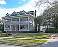
Edward Albert Palmer Memorial Chapel and Autry House
The Edward Albert Palmer Memorial Chapel and Autry House (at 6221 and 6265 Main St.) are historic buildings. They were added to the National Register on October 31, 1984.

Rothko Chapel
The Rothko Chapel (at 1409 Sul Ross Ave.) is a famous chapel known for its unique art and quiet atmosphere. It's a place for meditation and reflection. It was listed on August 16, 2000.

Sabine Street Bridge over Buffalo Bayou
The Sabine Street Bridge over Buffalo Bayou (at Sabine St. at Buffalo Bayou) is another historic bridge. It was added to the National Register on September 28, 2007.
.jpg)
St. Elizabeth's Hospital
St. Elizabeth's Hospital (at 4514 Lyons Ave.) is a historic hospital building. It was listed on March 6, 2019.

San Jacinto Senior High School
San Jacinto Senior High School (at Houston Community College Central, 1300 Holman St.) is a historic school building. It was added to the National Register on December 5, 2012.

Schlumberger Well Surveying Corporation Building
The Schlumberger Well Surveying Corporation Building (at 2720 Leeland Street) is a historic building related to the oil and gas industry. It was listed on June 24, 2018.

Sears, Roebuck and Company Warehouse and Service Center
The Sears, Roebuck and Company Warehouse and Service Center (at 5901 Griggs Rd.) is a large historic building that was once a major store and warehouse. It was added to the National Register on June 25, 2020.

Cleveland Harding Sewall House
The Cleveland Harding Sewall House (at 3452 Inwood St.) is a historic home. It was listed on April 14, 1975.

Sheridan Apartments
The Sheridan Apartments (at 802-804 McGowen St.) is a historic apartment building. It was added to the National Register on August 2, 1984.

Star Engraving Company Building
The Star Engraving Company Building (at 3201 Allen Pkwy.) is a historic building that once housed an engraving company. It was listed on January 6, 1995.
.jpg)
Joseph R. and Mary M. Stevenson House
The Joseph R. and Mary M. Stevenson House (at 804 Harold St.) is a historic home. It was added to the National Register on March 21, 1996.

Telephone Road Bridge over Brays Bayou
The Telephone Road Bridge over Brays Bayou (at Telephone Rd. at Brays Bayou) is another historic bridge. It was listed on November 29, 2007.

Temple Beth Israel
Temple Beth Israel (at 3517 Austin St.) is a historic synagogue. It was added to the National Register on March 1, 1984.

Trinity Church
Trinity Church (at 3404 S. Main St.) is a historic church building. It was listed on May 26, 1983.

Union Transfer and Storage Building
The Union Transfer and Storage Building (at 1113 Vine St.) is a historic warehouse. It was added to the National Register on January 16, 2001.
.jpg)
Historic Neighborhoods and Districts
Some entire neighborhoods are considered historic because they have many old and important buildings.
Boulevard Oaks Historic District
The Boulevard Oaks Historic District is a neighborhood roughly bounded by North Blvd., South Blvd., Hazard, and Mandell Streets. It's known for its beautiful old homes and tree-lined streets. It became a historic district on February 22, 2002.

Broadacres Historic District
The Broadacres Historic District includes homes on 1300-1506 North Blvd. and 1305-1515 South Blvd. This area is known for its large, fancy homes. It was added to the National Register on April 16, 1980.

Courtlandt Place Historic District
The Courtlandt Place Historic District (at 2-25 Courtlandt Pl.) is a private street with many historic homes. Several individual houses on this street are also listed separately. It became a historic district on December 3, 1980.

Freedmen's Town Historic District
The Freedmen's Town Historic District is an important neighborhood roughly bounded by Genesse, West Dallas, Arthur, and W. Gray Streets. It was one of the first communities in Houston settled by formerly enslaved people after the Civil War. It was listed on January 17, 1985.

Idylwood Historic District
The Idylwood Historic District is a neighborhood roughly bounded by Lawndale Ave., N. MacGregor Way, Sylvan Rd., and Wayside Dr. It was added to the National Register on July 6, 2011.
Near North Side Historic District
The Near North Side Historic District is a neighborhood roughly bounded by Little White Oak Bayou, Hogan, I-45, and the block between N Main and Keene. It was listed on November 29, 2010.
Old Sixth Ward Historic District
The Old Sixth Ward Historic District is one of Houston's oldest neighborhoods, bounded by Washington, Union, Houston, Capitol, and Glenwood Cemetery. It has many Victorian-era homes. It became a historic district on January 23, 1978.
.jpg)
San Felipe Courts Historic District
The San Felipe Courts Historic District (at 1 Allen Pkwy. Village) is a historic housing development. It was added to the National Register on February 16, 1988.
.jpg)
W-K-M Company, Inc. Historic District
The W-K-M Company, Inc. Historic District is an area roughly bounded by Commerce, Sampson, Preston, and Velasco Streets. It relates to an important industrial company. It was listed on June 25, 2018.
West Eleventh Place Historic District
The West Eleventh Place Historic District (at 1-8 W. 11th Pl.) is a small historic area. It was added to the National Register on April 14, 1997.

Westmoreland Historic District
The Westmoreland Historic District is a neighborhood bounded by Hawthorne, Burlington, and Marshall Aves., and Garott St. It was listed on August 16, 1994.

Former Listings
Sometimes, places are removed from the National Register, usually because they were torn down or changed too much.
Houston Turn-Verein
The Houston Turn-Verein (at 5202 Almeda Rd.) was a historic building. It was added to the National Register on March 21, 1978, but was removed on July 24, 2017, because it was demolished in 1993.
Allen Paul House
The Allen Paul House (at 2201 Fannin St.) was also known as the Witch's Hat House because of its unique roof. It was listed on September 27, 1980, but was removed on June 8, 1998, after being demolished in 1997.
Images for kids
-
James L. Autry House

