
Navigation Structures at Saugatuck Harbor facts for kids
Quick facts for kids |
|
|
Navigation Structures at Saugatuck Harbor
|
|
 |
|

Location in Michigan

Location in the United States
|
|
| Location | Mouth of the Kalamazoo River, Saugatuck, Michigan |
|---|---|
| Area | 1.7 acres (0.69 ha) |
| Built | 1904 |
| Built by | Burke, Smith & Nelson |
| Architectural style | Utilitarian |
| NRHP reference No. | 01001216 |
| Added to NRHP | November 8, 2001 |
The Navigation Structures at Saugatuck Harbor are like two long arms reaching out into Lake Michigan from the mouth of the Kalamazoo River. They are located near the town of Saugatuck, Michigan. These important structures help guide boats safely in and out of the harbor. Because they are so important to history, they were added to the National Register of Historic Places in 2001.
Contents
History of Saugatuck Harbor Piers
Saugatuck started as a busy town for shipping lumber in the 1830s. To help ships find their way, the government built a lighthouse in 1838. Later, in the mid-1800s, some private groups dug out the Kalamazoo River channel. They also built two simple piers at the river's entrance.
Improving the River Channel
In 1869, the United States Army Corps of Engineers began working to make Saugatuck's harbor better. By 1883, they had made the piers much longer. The north pier was about 1,907 feet long, and the south pier was about 3,863 feet long. However, the river channel kept filling up with sand and dirt, a process called "silting." This meant it needed to be dug out, or "dredged," all the time.
Building New Piers
To fix the problem of constant silting, the Corps of Engineers suggested a new plan in 1896. They wanted to create a completely new channel for the river. This new channel would be north of the old one and would cut through gravel, which would not silt up as easily.
In 1903, a company called Burke, Smith & Nelson was hired to build the new piers. Construction started in 1904 after the land was bought. Large wooden boxes, called "cribs," were built in Muskegon. These cribs were then floated to Saugatuck and put into place. The rest of the work was done right there.
Completion and Repairs
The construction of these new structures finished in 1906. It cost a lot of money, about $273,783.23. Later, between 1936 and 1938, the piers were repaired and covered with concrete. More repairs and updates happened in 1974, and again in 1981 and 1982. These repairs helped keep the piers strong and useful for many years.
The Navigation Structures at Saugatuck Harbor are made of two piers. They are about 200 feet apart and run parallel to each other, guiding boats into the Kalamazoo River. The North Pier is 2,778 feet long, and the South Pier is 2,514 feet long. There are lights at the end of each pier to help guide ships, especially at night.
How the Piers are Built
The very ends of the piers are made of strong wooden boxes, called "timber cribs," filled with stone. Each of these cribs is 24 feet wide and 100 feet long. Large rocks, called "riprap," are placed on both sides of these cribs to protect them from waves.
Further inland from the cribs, the rest of the piers are built using wooden poles, called "pilings," driven into the ground. These pilings are spaced about 13 feet apart and the space between them is filled with stone. The parts of the piers closer to the shore are 13 to 14 feet wide and also built with wood pilings and filled with stone. As mentioned before, the tops of the piers were covered with concrete in the 1930s to make them even stronger.
Gallery
-
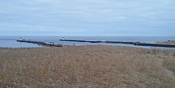
View of structures looking northwest
-
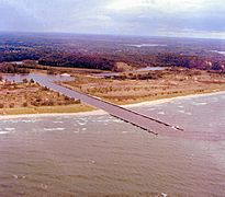
Aerial view looking southeast
-
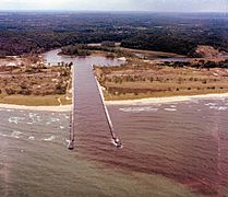
Aerial view looking east
-
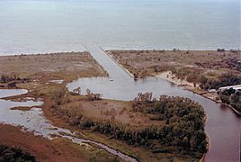
Aerial view looking west


