Navis facts for kids
Quick facts for kids
Navis
|
||
|---|---|---|
 |
||
|
||
| Country | Austria | |
| State | Tyrol | |
| District | Innsbruck Land | |
| Area | ||
| • Total | 64.13 km2 (24.76 sq mi) | |
| Elevation | 1,337 m (4,386 ft) | |
| Time zone | UTC+1 (CET) | |
| • Summer (DST) | UTC+2 (CEST) | |
| Postal code |
6143
|
|
| Area code | 05278 | |
| Vehicle registration | IL | |
| Website | www.navis.tirol.gv.at | |
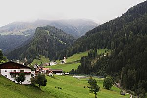
Navis is a small town, also called a municipality, in Austria. It's located in the Tyrol region, about 19 kilometers (12 miles) southeast of the city of Innsbruck. Navis is nestled in a beautiful valley that shares its name, which is a side valley of the larger Wipptal valley.
The area of Navis is quite large. It stretches from the Sill river up to high mountains. These include the 2,359-meter (7,740-foot) Klammjoch saddle. It also reaches the 2,886-meter (9,469-foot) Lizumer Reckner. Both are part of the Tux Alps mountain range. The town gets its fresh drinking water from the clean Navisbach stream.
No one knows for sure where the name "Navis" comes from. However, people started settling in this area around the end of the 13th century. In the 15th and 16th centuries, valuable metals like copper and silver were discovered here.
The number of people living in Navis has changed over time. Here's a look at how the population has grown.
| Historical population | ||
|---|---|---|
| Year | Pop. | ±% |
| 1869 | 792 | — |
| 1880 | 812 | +2.5% |
| 1890 | 770 | −5.2% |
| 1900 | 830 | +7.8% |
| 1910 | 861 | +3.7% |
| 1923 | 862 | +0.1% |
| 1934 | 922 | +7.0% |
| 1939 | 908 | −1.5% |
| 1951 | 1,056 | +16.3% |
| 1961 | 1,104 | +4.5% |
| 1971 | 1,484 | +34.4% |
| 1981 | 1,651 | +11.3% |
| 1991 | 1,846 | +11.8% |
| 2001 | 1,907 | +3.3% |
| 2011 | 1,967 | +3.1% |
See also
 In Spanish: Navis (Austria) para niños
 | Charles R. Drew |
 | Benjamin Banneker |
 | Jane C. Wright |
 | Roger Arliner Young |


