Navolato, Sinaloa facts for kids
Quick facts for kids
Navolato, Sinaloa
|
||
|---|---|---|

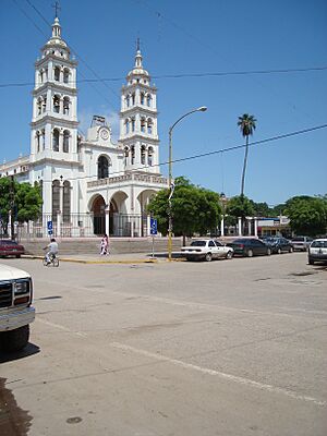
Parroquia de San Francisco de Asís in Navolato
|
||
|
||
| Country | ||
| State | Sinaloa | |
| Municipality | Navolato | |
| Population
(2010)
|
||
| • Total | 28,676 | |
| Time zone | UTC-7 (Pacific (US Mountain)) | |
| Area code(s) | 672 | |
Navolato is a city in the Mexican state of Sinaloa. It is on the central coast, next to the Gulf of California. Navolato is the main city for the municipality of the same name.
In 2010, the city of Navolato had about 29,153 people. The whole municipality had 135,603 people. Navolato is about 25 kilometers (15.5 miles) west of Culiacán. You can get there by road. The municipality covers 2,285 km2 (882 sq mi). It includes smaller towns like Campo Gobierno and General Ángel Flores (La Palma).
The name Navolato comes from the native Nahuatl language. People in Navolato grow sugarcane, corn, and other farm products. Popular places to visit nearby are Altata, Nuevo Altata, and El Tambor.
Contents
Navolato is a place rich in music and food. People here love to express themselves through music. They use bandas (brass bands), trios, and quartets. These groups sing about their land and its beauty.
Music and Famous Songs
Many artists have used their musical talent to sing about Sinaloa. This is the state where Navolato is located. Severiano Briseño Chávez wrote "El Sinaloense." This is one of the most famous songs from Sinaloa. Jose Angel Espinoza Ferrusquilla also honored his home with the song "En Sinaloa Nací" (Born in Sinaloa).
Valente Del Real, a singer, was born in Navolato in 1985. He started his music career at age eleven. He learned to play many instruments. These included drums, bass, and guitar. His voice is often compared to Valentin Elizalde. He often performs with Banda Pueblo Lindo.
Delicious Local Foods
The Altata Bay is home to many sea creatures. Fishermen catch shrimp, tuna, clams, oysters, and marlin. They also catch many types of freshwater fish. People in Navolato enjoy many fish dishes. Some popular ones are fish meatballs and chile rellenos filled with crab. Their famous Sinaloa-style shrimp Ceviche is a must-try.
For dessert, they love Jamoncillo, which is a sweet milk candy. It is made from sugar cane. But their most famous dessert is tacuarines. These are corn, flour, and water cookies. They are often shaped like circles.
Navolato is on the coast of the Gulf of California. The larger state of Sinaloa covers about 58,091 square kilometers (22,429 square miles). This area is a bit smaller than Norway. Sinaloa has three main types of land. There is a flat coastal plain in the west. Mountains (sierras) are in the east. Valleys lie between them.
Population and Languages
In 2000, Sinaloa had over 2.5 million people. About 1.26 million were men and 1.27 million were women. The population density was about 44 people per square kilometer.
Most people in Navolato speak Spanish. A small number, about 2.2% of the population, speak native languages. Most people, about 77%, are Roman Catholic. Almost 3% are Protestant. There are also Jehovah's Witnesses and people with no religion.
The name Sinaloa comes from the Chaita language. It means "pithaya" (a thorny plant) and "rounded." The pithaya plant is very common in the region.
Navolato has a warm climate, even in cooler months. Daytime temperatures can reach 90 degrees Fahrenheit (32 degrees Celsius). In winter, from December to February, temperatures can still be around 80 degrees Fahrenheit (27 degrees Celsius). Most rain falls in July, August, and September. This brings cooler temperatures near the coast.
Navolato's climate is warm and sunny for most of the year. The table below shows average temperatures and rainfall.
| Climate data for Navolato (1951–2010) | |||||||||||||
|---|---|---|---|---|---|---|---|---|---|---|---|---|---|
| Month | Jan | Feb | Mar | Apr | May | Jun | Jul | Aug | Sep | Oct | Nov | Dec | Year |
| Record high °C (°F) | 39.5 (103.1) |
39.5 (103.1) |
37.5 (99.5) |
41.5 (106.7) |
42.0 (107.6) |
43.0 (109.4) |
44.0 (111.2) |
42.0 (107.6) |
43.0 (109.4) |
42.0 (107.6) |
42.0 (107.6) |
37.0 (98.6) |
44.0 (111.2) |
| Mean daily maximum °C (°F) | 27.7 (81.9) |
29.2 (84.6) |
31.0 (87.8) |
33.1 (91.6) |
35.6 (96.1) |
36.4 (97.5) |
36.6 (97.9) |
36.4 (97.5) |
35.5 (95.9) |
35.1 (95.2) |
32.6 (90.7) |
28.6 (83.5) |
33.2 (91.8) |
| Daily mean °C (°F) | 19.4 (66.9) |
20.2 (68.4) |
21.6 (70.9) |
23.7 (74.7) |
26.3 (79.3) |
29.1 (84.4) |
30.0 (86.0) |
30.2 (86.4) |
29.6 (85.3) |
27.9 (82.2) |
24.0 (75.2) |
20.0 (68.0) |
25.2 (77.4) |
| Mean daily minimum °C (°F) | 11.1 (52.0) |
11.1 (52.0) |
12.2 (54.0) |
14.2 (57.6) |
17.0 (62.6) |
21.7 (71.1) |
23.4 (74.1) |
24.0 (75.2) |
23.8 (74.8) |
20.8 (69.4) |
15.3 (59.5) |
11.4 (52.5) |
17.2 (63.0) |
| Record low °C (°F) | 4.0 (39.2) |
−1.0 (30.2) |
7.5 (45.5) |
9.0 (48.2) |
11.0 (51.8) |
10.0 (50.0) |
10.0 (50.0) |
18.0 (64.4) |
16.0 (60.8) |
11.0 (51.8) |
5.0 (41.0) |
5.0 (41.0) |
−1.0 (30.2) |
| Average precipitation mm (inches) | 22.6 (0.89) |
9.2 (0.36) |
2.1 (0.08) |
1.2 (0.05) |
7.4 (0.29) |
6.5 (0.26) |
71.6 (2.82) |
120.8 (4.76) |
134.5 (5.30) |
76.7 (3.02) |
6.5 (0.26) |
11.5 (0.45) |
470.6 (18.53) |
| Average precipitation days (≥ 0.1 mm) | 2.0 | 1.1 | 0.4 | 0.2 | 0.1 | 1.2 | 7.4 | 9.8 | 8.7 | 2.9 | 1.0 | 1.3 | 36.1 |
| Source: Servicio Meteorologico Nacional | |||||||||||||
Navolato is part of a group called the Western Hemisphere Shorebird Reserve Network. This group works with the U.S. and Alaska. They protect Pacific Flyway Shorebirds that breed in Canada, Alaska, and the western U.S.
Plants in Navolato include oaks, poplars, cieba, and mangroves. Mangroves are evergreen trees that grow along the coast. You can also find fruits like lemons, peaches, and pears. Animals in this area include deer, wildcats, badgers, wild boar, coyotes, and tlacuaches.
Fishing is also a very important part of Navolato's economy. It ranks second in the country for the value of its production. It is third for fish and other seafood.
Navolato's economy relies heavily on its farms. The land here is very good for growing many different crops. Navolato is a major producer of sugarcane, rice, vegetables, wheat, and beans.
Agriculture and Fishing Industries
Navolato is known for its farming. It leads in producing sugar cane, rice, vegetables, wheat, beans, and seafood. Fishing and growing plants are also very important. These industries bring a lot of money to the region. Farming and raising livestock make up about 21% of the economy.
Many crops are grown using irrigation near sea level. This makes them very valuable. Navolato exports many fruits and vegetables. These exports make up over 60% of all exports from Sinaloa.
Navolato is a top producer of vegetables like tomatoes, cucumbers, pumpkins, potatoes, chilies, and eggplant. For fruits, they grow mangos, cantaloupes, and watermelons. Grains include corn, beans, soybeans, rice, wheat, and sorghum.
Raising livestock is the second largest business. Farmers produce sausage, cheese, and milk from their animals. The fishing industry is also very strong because Navolato is right on the Pacific Ocean.
Trade and Transportation
Navolato transports its food and vegetables using two big international airports. These are Mazatlan and Topolobampo. Farm products are sent from Navolato to markets all over Mexico. Local railroads also help transport goods. Navolato's economy is growing. They are finding new ways to develop their cities. This includes improving telecommunications and electricity.
See also
 In Spanish: Navolato para niños
 | William Lucy |
 | Charles Hayes |
 | Cleveland Robinson |


