Nelson River (Saint-Charles River tributary) facts for kids
Quick facts for kids Nelson river |
|
|---|---|

Image of the course of the river.
|
|
|
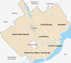
Location of the mouth of the river in Quebec City
|
|
| Native name | Rivière Nelson |
| Country | Canada |
| Province | Quebec |
| Region | Capitale-Nationale |
| Cities | Quebec City |
| Physical characteristics | |
| Main source | Agricultural stream Canadian Force Base of Valcartier 202 units? 46°57′46″N 71°26′52″W / 46.96274°N 71.44785°W |
| River mouth | Saint-Charles River Quebec (city) (sector Les Saules) 150 m 46°52′06″N 71°22′28″W / 46.868456°N 71.374328°W |
| Length | 26.9 km (16.7 mi) |
| Basin features | |
| River system | Saint Lawrence River |
| Basin size | 70 km2 (27 sq mi) |
| Tributaries |
|
The Nelson River is a river found in the Capitale-Nationale region of Quebec, Canada. It is an important part of the Saint-Charles River's watershed. A watershed is an area of land where all the water drains into a single river or lake.
The Nelson River flows through different areas:
- The municipality of Saint-Gabriel-de-Valcartier in the La Jacques-Cartier Regional County Municipality.
- Parts of Quebec City, including the La Haute-Saint-Charles area and Neufchâtel-Nord.
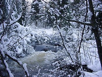
During winter, the river's surface usually freezes from early December to late March. It's generally safe to walk on the ice from late December to early March. The amount of water in the river changes with the seasons and how much rain or snow falls. The biggest flood usually happens in March or April.
River's Journey and Surroundings
The Nelson River's sub-basin covers the western part of the Saint-Charles River's watershed. It stretches across parts of Quebec City and the town of Saint-Gabriel-de-Valcartier. Long ago, people sometimes called it the "Grand-Désert river."
The river starts near the Canadian Forces Base of Valcartier, which is a military base. From there, it flows through the Val-Bélair area before joining the Saint-Charles River. This meeting point is a little bit upstream from where Quebec City gets its drinking water. The Nelson River is about 30 kilometres (19 mi) (about 18.6 miles) long, and its watershed covers 70 km2 (27 sq mi) (about 27 square miles).
The land around the Nelson River doesn't change much in height from where the river starts to where it ends. However, there are a few mountains like Mount of the Three Augustines, Mount Brillant, and Mount Rolland-J.-Auger. People sometimes enjoy outdoor activities on these mountains, especially at the Canadian Forces Base of Valcartier, where there's a ski center.
Nature and Wildlife
Most of the land in the Nelson River's watershed is covered by forests. But there are also two areas where farming takes place, mainly raising chickens and growing grains.
As the river winds through wooded areas and then more developed parts of the city, it's home to various animals. Even though there's some pollution in the last few kilometers of the river, you can still find creatures like trout, mallards (a type of duck), and different kinds of amphibians (like frogs and salamanders).
How the River Flows
From Lac de la Savane, the Nelson River flows for about 26.9 kilometres (16.7 mi) (about 16.7 miles), dropping 52 metres (171 ft) (about 170 feet) in height. Here's a simplified look at its path:
- It flows south, making a big curve to the west and passing through a small lake.
- Then it turns southeast, reaching the outlet of Lac Blanc.
- It continues southeast until it meets La Petite Rivière.
- The river then heads southwest, crossing Route 371 (Valcartier Boulevard) and going past the Golf Le Castor area. It also goes around Mont Brillant, which is 444 metres (1,457 ft) (about 1,457 feet) tall.
- It flows through the western part of La Haute-Saint-Charles in Quebec City, then back into Saint-Gabriel-de-Valcartier, and finally southeast to Route 573 (Route de la Bravoure).
- Next, it flows east, winding through the Val-Saint-Michel area and collecting water from the Savard stream.
- Finally, it continues east and then northeast, winding its way to its mouth.
The Nelson River joins the Saint-Charles River in the Château-d'Eau area of Quebec City. This meeting point is about 13.3 kilometres (8.3 mi) (about 8.3 miles) east of where the Saint-Charles River itself ends.
Naming the River
There's a street in Quebec City called "rue de la Rivière-Nelson" in the La Haute-Saint-Charles district.
The name "Nelson" comes from Neilson McBain (1898-1985). He was the mayor of Saint-Gabriel-de-Valcartier in 1949 and owned land that the Nelson River flowed through. The river's name is spelled a little differently from his last name.
This river was once known as "Mill River." This older name appeared on a document when the property was bought in 1925. By 1963, the river was already known by its current name. The name "Nelson River" was officially recognized on March 28, 1974, by the Commission de toponymie du Québec, which is Quebec's place-name commission.
 | Claudette Colvin |
 | Myrlie Evers-Williams |
 | Alberta Odell Jones |


