
New Bedford, Illinois facts for kids
Quick facts for kids
New Bedford
|
|
|---|---|

Location of New Bedford in Bureau County, Illinois.
|
|
.svg)
Location of Illinois in the United States
|
|
| Country | United States |
| State | Illinois |
| County | Bureau |
| Township | Greenville |
| Area | |
| • Total | 0.155 sq mi (0.40 km2) |
| • Land | 0.155 sq mi (0.40 km2) |
| • Water | 0.00 sq mi (0 km2) 0% |
| Population
(2020)
|
|
| • Total | 76 |
| • Density | 490/sq mi (189.3/km2) |
| Time zone | UTC-6 (CST) |
| • Summer (DST) | UTC-5 (CDT) |
| ZIP Code(s) |
61346
|
| Area codes | 815 & 779 |
| FIPS code | 17-52155 |
| Wikimedia Commons | New Bedford, Illinois |
New Bedford is a small village located in Bureau County, Illinois, United States. In 2020, about 76 people lived there. It is part of the Ottawa Micropolitan Statistical Area, which is a group of cities and towns that are closely connected.
Contents
History of New Bedford
Early Settlement and Thomas' Ferry
In October 1836, a man named Henry Thomas bought land in the area now known as New Bedford. For many years, this was the only officially registered piece of land there.
In the spring of 1837, Cyrus Watson built a cabin on Thomas' land. He thought the land was empty. Around this time, a state road was built from Princeton to Prophetstown. This road crossed the Green River right at New Bedford. Henry Thomas then built a ferry boat to help people cross the river. For a long time, this spot was known as Thomas' Ferry.
-
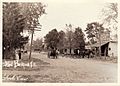
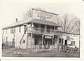
Main Street in New Bedford, Illinois, around 1910. This picture looks northward from the west side of Main Street.
-
Main Street in New Bedford, Illinois, around 1910. This picture looks northward from the east side of Main Street.
-
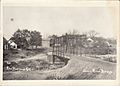
The Green River bridge around 1910. This view looks northward across the bridge. This part of the river is now called the Old Channel.
-
The Green River bridge around 1910. This view looks southward across the bridge. The large house on the right belonged to the Bollman family.
-
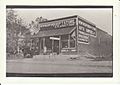
Spratt's Department store on the east side of Main Street around 1910. The cement step from the store is still there today, across from the Post Office.
-
F. Janderson Department store on the west side of Main Street around 1910.


Geography of New Bedford
Where is New Bedford Located?
New Bedford is located at 41°30′47″N 89°43′09″W / 41.51306°N 89.71917°W. This is its exact spot on a map.
Size of the Village
According to information from 2021, New Bedford covers a total area of about 0.16 square miles (0.41 km2). All of this area is land, meaning there are no large bodies of water like lakes or big rivers within the village limits.
Population and People of New Bedford
Population Changes Over Time
The number of people living in New Bedford has changed over the years:
| Historical population | |||
|---|---|---|---|
| Census | Pop. | %± | |
| 1880 | 55 | — | |
| 1960 | 166 | — | |
| 1970 | 152 | −8.4% | |
| 1980 | 152 | 0.0% | |
| 1990 | 65 | −57.2% | |
| 2000 | 95 | 46.2% | |
| 2010 | 75 | −21.1% | |
| 2020 | 76 | 1.3% | |
| U.S. Decennial Census | |||
Who Lives in New Bedford?
Based on the 2020 census, there were 76 people living in New Bedford. These people made up 32 households, and 18 of these were families.
The village has about 490.32 inhabitants per square mile (189.31/km2) people per square mile. Most of the people living in New Bedford (about 94.74%) are White. About 5.26% of the population are from two or more races. A small number, about 2.63%, are of Hispanic or Latino background.
Households and Families
Out of the 32 households:
- 12.5% had children under 18 living with them.
- 37.50% were married couples living together.
- 9.38% had a female head of the household with no husband.
- 43.75% were not families (like single people living alone).
About 40.63% of all households were made up of just one person. And 25.00% of households had someone living alone who was 65 years old or older. On average, each household had about 2.22 people, and each family had about 1.78 people.
Age and Income
The ages of people in the village varied:
- 8.8% were under 18 years old.
- 14.0% were between 18 and 24.
- 15.8% were between 25 and 44.
- 15.8% were between 45 and 64.
- 45.6% were 65 years old or older.
The average age in New Bedford was 59.5 years.
The average income for a household in the village was $47,500 per year. For families, the average income was $57,500. The average income per person in the village was $23,430. About 22.2% of families and 26.3% of all people in New Bedford lived below the poverty line. This included 80.0% of those under 18 and 26.9% of those 65 or older.
See also
 In Spanish: New Bedford (Illinois) para niños
