New Bloomfield, Pennsylvania facts for kids
Quick facts for kids
Bloomfield, Pennsylvania
|
|
|---|---|
|
Borough
|
|

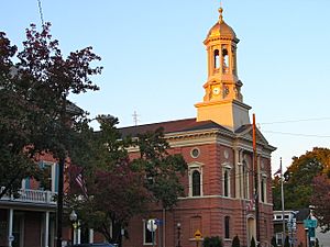
Perry County Courthouse
|
|

Location of New Bloomfield in Perry County
|
|
| Country | United States |
| State | Pennsylvania |
| County | Perry |
| Settled | 1824 |
| Incorporated | 1831 |
| Area | |
| • Total | 0.61 sq mi (1.58 km2) |
| • Land | 0.61 sq mi (1.58 km2) |
| • Water | 0.00 sq mi (0.00 km2) |
| Elevation
(center of borough)
|
675 ft (206 m) |
| Highest elevation
(northern boundary)
|
1,000 ft (300 m) |
| Lowest elevation
(southeast corner by Little Juniata Creek)
|
640 ft (200 m) |
| Population
(2020)
|
|
| • Total | 1,219 |
| • Density | 1,995.09/sq mi (770.78/km2) |
| Time zone | UTC-5 (Eastern (EST)) |
| • Summer (DST) | UTC-4 (EDT) |
| Zip Code |
17068
|
| Area code(s) | 717 |
| FIPS code | 42-07040 |
| Website | http://www.bloomfieldboro.org/ |
Bloomfield, often called New Bloomfield, is a small town in Pennsylvania, USA. It is the main town, or county seat, of Perry County. This town is part of the larger Harrisburg–Carlisle metropolitan statistical area. In 2020, about 1,244 people lived here.
Contents
History of New Bloomfield
New Bloomfield was first planned out in 1823. It got its name because of the many blooming clovers growing nearby. A post office opened in the town in 1825. The town was officially made a borough in 1831.
Understanding the Name
The post office in the town was named New Bloomfield in 1825. The U.S. government still uses this name for the area. However, when the town officially became a borough in 1831, it was named Bloomfield. So, both names are used, but Bloomfield is the official name of the borough.
Geography of the Area
According to the U.S. Census Bureau, Bloomfield covers about 0.5 square miles (1.58 square kilometers). All of this area is land. The town is completely surrounded by Centre Township.
Population and People
| Historical population | |||
|---|---|---|---|
| Census | Pop. | %± | |
| 1840 | 412 | — | |
| 1850 | 581 | 41.0% | |
| 1860 | 661 | 13.8% | |
| 1870 | 655 | −0.9% | |
| 1880 | 673 | 2.7% | |
| 1890 | 737 | 9.5% | |
| 1900 | 772 | 4.7% | |
| 1910 | 762 | −1.3% | |
| 1920 | 778 | 2.1% | |
| 1930 | 730 | −6.2% | |
| 1940 | 858 | 17.5% | |
| 1950 | 1,098 | 28.0% | |
| 1960 | 987 | −10.1% | |
| 1970 | 1,032 | 4.6% | |
| 1980 | 1,109 | 7.5% | |
| 1990 | 1,092 | −1.5% | |
| 2000 | 1,077 | −1.4% | |
| 2010 | 1,247 | 15.8% | |
| 2020 | 1,244 | −0.2% | |
| 2021 (est.) | 1,248 | 0.1% | |
| Sources: | |||
In the year 2000, there were 1,077 people living in Bloomfield. These people lived in 396 households, with 255 of them being families. The population density was about 1,983 people per square mile.
About 29.8% of the households had children under 18 living there. Also, 51.0% of households were married couples. About 15.2% of households had someone living alone who was 65 years old or older.
The average age of people in the borough was 42 years old.
- 19.9% were under 18 years old.
- 9.3% were between 18 and 24 years old.
- 24.6% were between 25 and 44 years old.
- 21.4% were between 45 and 64 years old.
- 24.9% were 65 years old or older.
Arts and Culture in Bloomfield
The Perry County Courthouse is an important building in New Bloomfield. It is listed on the National Register of Historic Places. This means it is a special place recognized for its history and architecture.
Famous People from Bloomfield
- Musa Smith is a professional football player who comes from Bloomfield.
See also
 In Spanish: Bloomfield (Pensilvania) para niños
 | Laphonza Butler |
 | Daisy Bates |
 | Elizabeth Piper Ensley |


