New Jersey v. New York facts for kids
Quick facts for kids New Jersey v. New York |
|
|---|---|

|
|
| Argued January 12, 1998 Decided May 26, 1998 |
|
| Full case name | State of New Jersey v. State of New York |
| Citations | 523 U.S. 767 (more)
118 S. Ct. 1726; 140 L. Ed. 2d 993; 1998 U.S. LEXIS 3405; 66 U.S.L.W. 4389; 98 Daily Journal DAR 5406; 1998 Colo. J. C.A.R. 2596; 11 Fla. L. Weekly Fed. S 563
|
| Holding | |
| New Jersey has sovereign authority over the filled land added to the original Island. New Jersey's exception to that portion of the Special Master's report concerning the Court's authority to adjust the original boundary line between the two States is sustained. The other exceptions of New Jersey and New York are overruled. | |
| Court membership | |
| Case opinions | |
| Majority | Souter, joined by Rehnquist, O'Connor, Kennedy, Ginsburg, Breyer |
| Concurrence | Breyer, joined by Ginsburg |
| Dissent | Stevens |
| Dissent | Scalia, joined by Thomas |
| Laws applied | |
| 1834 Compact between New York and New Jersey | |
New Jersey v. New York was a U.S. Supreme Court case from 1998. This important case decided that most of Ellis Island (about 83%) belongs to New Jersey, not New York State.
Contents
Why Was There a Dispute Over Ellis Island?
The story of why a part of New York State ended up inside New Jersey goes back a long time. It started in 1664, after the British took over a Dutch area called New Netherland.
How the Border Was First Set
When New Jersey was first created, its land grant had an unusual rule. It said New Jersey's territory was "westward of Long Island, and Manhatas Island." It was also bordered on the east by the sea and part of the Hudson River. This was different from other areas, where borders were usually set in the middle of a river.
Early Attempts to Fix the Border
People tried to sort out the border as early as 1804. The City of New York thought it could control all trade on its waters. But a case called Gibbons v. Ogden changed this. It decided that the U.S. government, not individual states, controlled trade between states. This was important for new steam ferry services in New York Harbor.
In 1830, New Jersey planned to sue to make the border clear. But the case never happened. Instead, the states made an agreement, called a compact, in 1834. The U.S. Congress approved this agreement.
The compact set the border in the middle of the Hudson River and New York Harbor. However, it gave all the islands in the channel to New York. The U.S. Supreme Court later confirmed this agreement in other cases.
Why the Island Grew and the Problem Returned
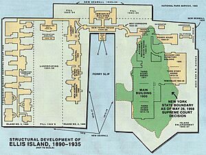
The U.S. government started making Ellis Island bigger in the late 1800s. They added land to build a large immigration station. This expansion continued until 1934.
New Jersey argued that these new, artificial parts of the island should be part of New Jersey. They said this was because the new land was outside New York's original border.
The arguments about who owned what came up again in the 1980s. This was when Ellis Island was being fixed up. They came up again in the 1990s when there were plans to develop the south side of the island.
New Jersey Takes New York to Court
Finally, New Jersey sued New York in 1997. The Supreme Court looked at the 1834 agreement. The land added by the government was not specifically given to New York in that agreement. Also, this new land was built in water that had been given to New Jersey.
So, the Supreme Court decided that the "new" land, which was decades old by then, must belong to New Jersey. A few judges disagreed. They used historical reasons and "common sense" to support New York's claim.
What Happened After the Court Decision?
The court's decision meant that the original, natural part of Ellis Island stayed with New York. But all the land that was later added by filling in water became part of New Jersey.
How the Island Is Divided Now
Ellis Island covers about 27.5 acres (11.1 hectares) of land. After the court case, both states worked together to draw the exact new border lines.
The original island, which is about 2.74 acres (1.11 hectares), and some other small areas (totaling 4.68 acres or 1.89 hectares) are still part of New York. This part of New York is like a small island of land completely surrounded by New Jersey.
This case might have been the first time a geographic information system (GIS) was used to help the Supreme Court make a decision. GIS uses computer maps to analyze geographic data.
Even though the court changed which state had control over most of the island, the U.S. government still owns Ellis Island. The change in state control did not affect most activities on the island. However, it did change some things, like sales taxes.


