New Salem Common Historic District facts for kids
Quick facts for kids |
|
|
New Salem Common Historic District
|
|

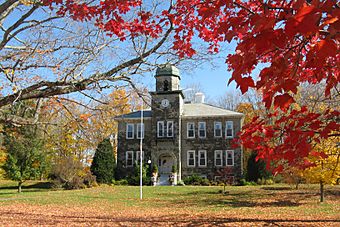
New Salem Academy
|
|
| Location | S. Main St., New Salem, Massachusetts |
|---|---|
| Area | 35 acres (14 ha) |
| Built | 1734 |
| NRHP reference No. | 78000443 |
| Added to NRHP | April 12, 1978 |
The New Salem Common Historic District is a special area in New Salem, Massachusetts. It's like a time capsule showing how the town center looked long ago. This district includes the town common, which is a big open space, and many old buildings. These buildings were important for the town's government and community life. Most of them were built in the 1700s and 1800s. This historic district was added to the National Register of Historic Places in 1978.
Exploring New Salem Common
The New Salem Common Historic District covers about 35 acres. It stretches along South Main Street. You can find 43 historic buildings within this area. It's a great place to see how towns were built in the past.
A Look Back in Time
The land for New Salem was first given out in 1734. People started settling here in 1737. The town grew because of its lumber and farming. It also became a busy stop for stagecoaches. These coaches traveled between Worcester and Brattleboro, Vermont.
The town center was first planned in 1737. It included a very large common area. The common you see today is a smaller part of that original space. Other old parts of the center include the town pound. This was a stone pen built to hold stray farm animals. There is also an old cemetery nearby.
In the 1800s, railroads became popular. They bypassed New Salem. This meant fewer people and businesses came through the town. As a result, the town's economy slowed down. Its population also became smaller.
What You Can See Today
Many important buildings are still standing in the district. The First Congregational Church was built in 1794. There are also two town halls. One was built in 1838 and another in 1909. You can also see the buildings of New Salem Academy. Some of these date back to the early 1800s.
The common itself has several memorials. These honor soldiers from different wars. There is also a special memorial for William Stacy. He was an early settler of New Salem. He also fought in the American Revolutionary War. Later, he helped settle the Ohio Country.


