New Weston, Ohio facts for kids
Quick facts for kids
New Weston, Ohio
|
|
|---|---|
|
Village
|
|

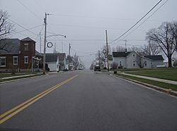
Main Street in western New Weston
|
|

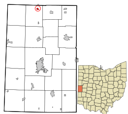
Location in Darke County and the state of Ohio.
|
|
| Country | United States |
| State | Ohio |
| County | Darke |
| Township | Allen |
| Area | |
| • Total | 0.26 sq mi (0.66 km2) |
| • Land | 0.26 sq mi (0.66 km2) |
| • Water | 0.00 sq mi (0.00 km2) |
| Elevation | 1,011 ft (308 m) |
| Population
(2020)
|
|
| • Total | 124 |
| • Density | 484.38/sq mi (187.20/km2) |
| Time zone | UTC-5 (Eastern (EST)) |
| • Summer (DST) | UTC-4 (EDT) |
| ZIP code |
45348
|
| Area code(s) | 419 |
| FIPS code | 39-55818 |
| GNIS feature ID | 2399487 |
New Weston is a small village located in Darke County, Ohio, United States. A village is a type of small town. In 2020, a count of the people living there, called a census, showed that 124 people lived in New Weston.
Contents
History of New Weston
New Weston was started in the 1880s. This happened when a railroad line was being built through Allen Township. The railroad company that built it was a very early version of what later became the Cincinnati, Jackson and Mackinaw Railroad. New Weston was one of the last communities to be founded in Darke County.
Geography of New Weston
New Weston is a small place. The United States Census Bureau says the village covers a total area of about 0.26 square miles (0.67 km2). This entire area is land, meaning there are no large lakes or rivers within the village limits.
Population and People
The number of people living in New Weston has changed over the years. Here's a quick look at how the population has grown and shrunk:
| Historical population | |||
|---|---|---|---|
| Census | Pop. | %± | |
| 1910 | 258 | — | |
| 1920 | 232 | −10.1% | |
| 1930 | 174 | −25.0% | |
| 1940 | 169 | −2.9% | |
| 1950 | 136 | −19.5% | |
| 1960 | 146 | 7.4% | |
| 1970 | 174 | 19.2% | |
| 1980 | 184 | 5.7% | |
| 1990 | 148 | −19.6% | |
| 2000 | 135 | −8.8% | |
| 2010 | 136 | 0.7% | |
| 2020 | 124 | −8.8% | |
| U.S. Decennial Census | |||
New Weston in 2010
In 2010, the census counted 136 people living in New Weston. These people lived in 45 different homes, and 33 of these were families.
- Population Density: There were about 523.1 inhabitants per square mile (202.0/km2) people for every square mile. This number tells us how crowded an area is.
- Housing: There were 57 housing units in total. A housing unit is a house, apartment, or other place where people live.
- Racial Makeup: Most people in the village (97.8%) were White. A small number (1.5%) were African American, and 0.7% were from two or more races. About 5.1% of the population identified as Hispanic or Latino.
Households and Families
- Homes with Kids: In 48.9% of the homes, there were children under 18 years old living there.
- Married Couples: About 51.1% of the homes had married couples living together.
- Single Parents: Some homes had a female head of household with no husband (17.8%), or a male head of household with no wife (4.4%).
- Individuals Living Alone: About 20% of all homes had only one person living there. Only a very small number (2.2%) of these were people aged 65 or older living alone.
- Average Size: On average, there were about 3 people in each home and almost 3.6 people in each family.
Age and Gender
- Median Age: The middle age of people in the village was 28 years old. This means half the people were younger than 28 and half were older.
- Young People: A large part of the population, 38.2%, was under 18 years old.
- Adults:
- 5.2% were between 18 and 24 years old.
- 31.6% were between 25 and 44 years old.
- 17.6% were between 45 and 64 years old.
- Seniors: About 7.4% of the people were 65 years old or older.
- Gender: The village had a nearly even split between genders, with 51.5% male and 48.5% female residents.
See also
 In Spanish: New Weston (Ohio) para niños

