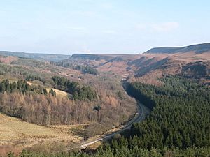
Newton Dale facts for kids
Newton Dale is a special narrow valley found inside the North York Moors National Park in North Yorkshire, England. It was formed a very long time ago by a huge amount of melting ice from a glacier. This powerful meltwater carved out the deep, narrow valley we see today. A stream called Pickering Beck still flows through the dale.
The dale begins between Goathland Moor and Lockton High Moor. From there, the water flows south towards Pickering. In its upper parts, the valley twists and turns a lot and is very deep. The bottom of the valley is about 150 meters (490 feet) above sea level.
You might see the name written as "Newtondale" or "Newton Dale." Maps from the Ordnance Survey and the North Yorkshire Moors Railway usually call it Newton Dale.
Contents
How Newton Dale Was Formed
This amazing valley was carved out by a huge amount of water during the last Ice Age. Early in the 1900s, a scientist named Percy Fry Kendall suggested that giant lakes, held back by ice, suddenly burst. This released a torrent of water that carved the dale.
Scientists think that just a few decades of this powerful water flow created the valley. All the earth that was dug out ended up in a large ancient lake called Lake Pickering. It's believed that the water flowed at an incredible speed, about 10,000 cubic meters (350,000 cubic feet) per second. This is ten times more water than the River Thames carries when it floods!
While Kendall's idea about huge pre-glacial lakes is now debated, everyone agrees on one thing: Newton Dale is very unusual. The small stream, Pickering Beck, that flows through it today doesn't have enough power to carve such a deep, narrow valley. The valley floor is about 150 meters (490 feet) above sea level, and its steep walls can reach up to 240 meters (790 feet) high at the top. In some places, this narrow valley is only about 500 meters (1,600 feet) wide.
History of Human Activity
For a long time, the upper part of Newton Dale was mostly untouched by people. That changed in the 1830s when the Whitby to Pickering Railway was built right through it. Before the railway, the main road between Pickering and Whitby used to go through Farwath and Levisham. Later, it was moved further east, and that road is now the A169.
Building the railway was a big challenge, especially across a marshy area called Fen Bog. The builders had to use bundles of wood, sheep fleeces, and extra earth to create a stable base for the railway tracks.
Fen Bog: A Special Place
At the very top of the dale, where water either flows towards Eller Beck or Pickering Beck, there is a special bog called Fen Bog. The Yorkshire Wildlife Trust looks after this area. The bog can be very deep, up to 18 meters (59 feet) in some places.
Fen Bog is a Special Area of Conservation. This means it's very important because of the unique grasses and butterflies that live there. The land was given to the Yorkshire Wildlife Trust in 1964 to remember two soldiers who died in the Second World War. A famous long-distance walking path, the Lyke Wake Walk, also crosses this bog.
Protecting the Dale
Newton Dale was named a Site of Special Scientific Interest (SSSI) in 1955. This is because it has a wide variety of plants and animals living in its wetlands, woodlands, and boggy areas. Its unique history, shaped by glaciers, is also a key reason for this special protection.
In 2015, some important work was done in the lower parts of the dale. A flood reservoir and over 160 "leaky dams" were built. These structures help control water flow and prevent flooding in Pickering. The town had been flooded four times between 1999 and 2007, with the last flood causing about £7 million worth of damage.
Getting Around Newton Dale
It's not easy to drive into the upper parts of Newton Dale. You can usually only park at the edges and then walk in. The North York Moors Railway has two stations right in the dale: Levisham and Newton Dale Halt. This makes it a great way to see the valley.
There used to be a forest drive road between the villages of Levisham and Stape until 2011. However, the Forestry Commission closed it. This was due to landslips, high repair costs, and to protect the delicate environment of the dale, especially because of its SSSI status.
If you enjoy walking, the Newtondale Horse Trail is a long-distance route. It's about 37 miles (60 kilometers) long and uses bridleways and paths through the dale, connecting Grosmont and Pickering.
 | Ernest Everett Just |
 | Mary Jackson |
 | Emmett Chappelle |
 | Marie Maynard Daly |


