
Ngaurukehu railway station facts for kids
Quick facts for kids
Ngaurukehu railway station
|
|||||||||||
|---|---|---|---|---|---|---|---|---|---|---|---|

Ngaurukehu railway station on 1970 map
|
|||||||||||
| Location | New Zealand | ||||||||||
| Coordinates | 39°36′41″S 175°42′30″E / 39.611300°S 175.708200°E | ||||||||||
| Elevation | 640 m (2,100 ft) | ||||||||||
| Line(s) | North Island Main Trunk | ||||||||||
| Distance | Wellington 270.79 km (168.26 mi) | ||||||||||
| History | |||||||||||
| Opened | 1 July 1909 | ||||||||||
| Closed | 1992 | ||||||||||
| Electrified | June 1988 | ||||||||||
| Services | |||||||||||
|
|||||||||||
Ngaurukehu, also spelled Ngarukehu or Ngaurakehu, was once a small train stop in New Zealand. It was located in the Ruapehu District, right in the beautiful Hautapu River valley. This stop was part of the important North Island Main Trunk railway line.
Ngaurukehu was about 9.64 km (5.99 mi) north of Mataroa and 3.91 km (2.43 mi) south of Turangarere. It was built on a gentle slope, making it 110 m (360 ft) higher than Mataroa but 62 m (203 ft) lower than Turangarere. Today, the railway line here has three "passing loops," which are extra tracks where trains can wait for others to pass.
Contents
The Story of Ngaurukehu Station
The railway line that runs through Ngaurukehu was built by the Public Works Department (PWD) in 1906. They also added a telegraph line, which was used for sending messages.
The railway line was officially handed over to New Zealand Railways (NZR) on 1 July 1908. However, the special side tracks, called "sidings," at Ngaurukehu didn't open until 1 July 1909. These sidings were very important. They helped reduce delays when trains were climbing the hill from Mataroa to Turangarere, allowing trains to wait for others to pass safely.
Station Staff and Upgrades
Ngaurukehu station had two "tablet porters" who helped manage the trains using a special system called "tablet working." There was also a signalbox, which controlled the train signals, and houses for the railway workers.
In 1955, two more houses were built for staff. By 1957, the crossing loop (the extra track for trains to pass) was made longer. It also got new "motor points" (switches that move tracks automatically) and "colour light signals" (traffic lights for trains). In 1973, plans were made to extend the loop even further.
Electrification of the Line
To the north of the station, there's a 112 m (367 ft) long tunnel called Ngaurukehu Tunnel, or sometimes the Rabbit Tunnel. In 1984, this tunnel was prepared for the railway line to be electrified. This meant trains could run on electricity instead of diesel. The line through Ngaurukehu was electrified in June 1988.
Ngaurukehu Scientific Reserve
To the west of the railway line, a special area of 215 acres (87 ha) was set aside on 20 August 1911. This area is now called the Maungakaretu (or Ngaurukehu) Scientific Reserve.
Protecting Rare Plants
This reserve is very important because it protects several types of plants. One of the most special is the rare Small-leaved Tree Daisy, also known as Olearia gardneri.
However, the reserve faces challenges from invasive plants. These are plants that are not native to the area and can take over, harming the native plants. Two common invasive plants found here are broom (Cytisus scoparius) and Khasia berry (Cotoneaster simonsii). Efforts are made to control these plants to protect the rare native species.
Images for kids
-
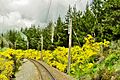
Broom between Ngaurukehu and Turangerere in November 2010.

