
Niassa Province facts for kids
Quick facts for kids
Niassa
|
|
|---|---|

Niassa, Province of Mozambique
|
|
| Country | Mozambique |
| Capital | Lichinga |
| Area | |
| • Total | 129,056 km2 (49,829 sq mi) |
| Highest elevation | 1,836 m (6,024 ft) |
| Population
(2017 census)
|
|
| • Total | 1,810,794 |
| • Density | 14.03107/km2 (36.34031/sq mi) |
| Postal code |
33xx
|
| Area code(s) | (+258) 271 |
Niassa is a large province in the country of Mozambique. Mozambique is located in southeastern Africa. The main city and capital of Niassa Province is Lichinga.
Niassa is known for its beautiful natural features. The Ruvuma River forms much of the northern border of the province. This river separates Niassa from the country of Tanzania. To the west, you'll find the huge Lake Niassa. This big lake forms the border with the country of Malawi.
The province also shares a very special place called the Niassa National Reserve. This large wildlife area is shared with the neighboring Cabo Delgado Province. It's a protected home for many different kinds of animals.
Areas of Niassa Province
Like a country is divided into states, a province is divided into smaller areas. These smaller areas are called districts. Niassa Province has 15 districts.
Niassa's Districts
Here are the 15 districts that make up Niassa Province:
- Cuamba District
- Lago District
- Lichinga District
- Majune District
- Mandimba District
- Marrupa District
- Maúa District
- Mavago District
- Mecanhelas District
- Mecula District
- Metarica District
- Muembe District
- N'gauma District
- Nipepe District
- Sanga District
Main Cities
Besides the districts, there are also a few important cities within Niassa Province. These are called municipalities.
- Cuamba
- Lichinga
- Metangula
Images for kids
-
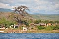
Lake Malawi in the part that corresponds to Mozambique
.jpg)
See also
 In Spanish: Provincia de Niassa para niños
