Ruvuma River facts for kids
The Ruvuma River, also known as the Rovuma River, is a large river in Africa. For most of its path, it forms the natural border between two countries: Tanzania and Mozambique. This river is about 998 kilometers (620 miles) long. It drains a huge area of land, covering around 155,000 square kilometers (60,000 square miles). The amount of water flowing out of the river into the ocean can vary a lot, from 475 to 2,286 cubic meters per second.
Quick facts for kids Ruvuma |
|
|---|---|

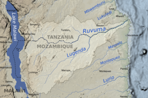
Map of the Ruvuma River drainage basin.
|
|
| Other name(s) | Rovuma |
| Country | Tanzania, Mozambique |
| Physical characteristics | |
| Main source | Ruvuma Region, Tanzania 1,000 m (3,300 ft) 10°45′00″S 35°40′00″E / 10.75000°S 35.66667°E |
| River mouth | Indian Ocean 0 m (0 ft) 10°28′28″S 40°26′13″E / 10.47444°S 40.43694°E |
| Length | 998 km (620 mi) |
| Basin features | |
| River system | Rovuma River |
| Basin size | 154,727.4 km2 (59,740.6 sq mi) to 155,316.4 km2 (59,968.0 sq mi) |
| Tributaries |
|
Contents
River Flow and Water Levels
The Ruvuma River's water flow changes throughout the year. On average, the river carries about 1,838 to 1,866 cubic meters of water per second. However, during heavy rains, the flow can increase a lot. The highest recorded flow has been around 22,053 to 22,630 cubic meters per second.
The river's flow is much higher during the rainy season. From January to April, the water levels are very high. The peak flow is usually in March. During the dry season, from July to October, the river's flow drops significantly. In September, it carries the least amount of water.
Rivers Joining the Ruvuma
Many smaller rivers flow into the Ruvuma River. These are called tributaries. The Ruvuma River itself is about 760 kilometers (472 miles) long. Its entire basin, including all its tributaries, covers about 155,316 square kilometers (59,968 square miles).
One of the largest tributaries joining the Ruvuma from the right side is the Lugenda River. It is about 650 kilometers (404 miles) long. The Lugenda River alone drains a huge area of land, over 60,000 square kilometers (23,166 square miles). Other important tributaries include the Muhuwesi and Lucheringo rivers.
Journey of the Ruvuma
The Ruvuma River starts on a high, rolling plateau in the Ruvuma Region of Tanzania. This area is about 1,000 meters (3,280 feet) above sea level. The river's journey begins with its head-stream flowing west. Then, it turns south and east.
As it flows east, the Ruvuma runs along the base of a dry, sandy plateau to its north. Most of the streams coming from this plateau are short. On the other side, the Ruvuma receives water from rivers like the Lujenda River, Msinje River, and Luchulingo River. These rivers flow from south to north through wide valleys.
The Lujenda River starts near Lake Chilwa, from a small lake called Lake Chiuta. The Lujenda then flows through a swampy valley into Lake Amaramba. From there, it becomes a wider stream, about 80 yards (73 meters) across.
Further downstream, the Ruvuma River changes a lot in width. It has many long, wooded islands that stay above water even when the river floods. These islands are often home to people. During the dry season, you can even walk across the river in many places. Near its mouth, where it meets the Indian Ocean, the river is about 1 mile (1.6 kilometers) wide. The lower part of the Ruvuma flows through a swampy valley. Its mouth is located near 10° 28′ S, 40° 30′ E.
Connecting Countries: The Unity Bridge
For a long time, people wanted to build a bridge across the Ruvuma River to connect Mozambique and Tanzania. This idea came up as early as 1975. Construction started but stopped because there wasn't enough money.
In 2002, the governments of both countries agreed to build a new bridge. This bridge, called the Unity Bridge, is 600 meters (1,968 feet) long. It was finally opened on May 25, 2010. The bridge is located at a place called Negomano. This spot is about 200 kilometers (124 miles) inland from the coast. It is also 100 kilometers (62 miles) from the nearest paved road in Mozambique.
Negomano was chosen for the bridge because it's a historically important place. It was where forces from Frelimo (a group fighting for Mozambique's independence) first entered Mozambique in 1964. It was also where German forces crossed the river in 1917 during a war. The construction of the Unity Bridge cost 28 million US dollars. Before the bridge, people used rafts to cross the river. These rafts could carry a few vehicles. However, the ferry sank in 2008 and was not replaced. During low water times, it's sometimes possible to cross the river in a good 4-wheel drive vehicle.
Another smaller bridge, called Unity Two, was also finished in 2007. This bridge is on the upper part of the Ruvuma River, near Matchedge in Niassa Province.
 | Leon Lynch |
 | Milton P. Webster |
 | Ferdinand Smith |

