Nicola River facts for kids
Quick facts for kids Nicola River |
|
|---|---|

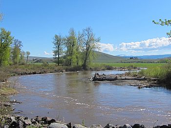
Nicola River near Douglas Lake
|
|
| Country | Canada |
| Province | British Columbia |
| City | Merritt |
| Physical characteristics | |
| Main source | 50°7′N 119°45′W / 50.117°N 119.750°W |
| River mouth | Thompson River Spences Bridge 50°25′39″N 121°18′58″W / 50.42750°N 121.31611°W |
| Basin features | |
| River system | Thompson River |
| Tributaries |
|
The Nicola River is a major river in British Columbia, Canada. It flows into the larger Thompson River at Spences Bridge. The river was named after Chief Nicola (Hwistesmexteqen). He was a very important leader of the Nlaka'pamux and Okanagan peoples. The area around the river is known as the Nicola Country.
Contents
Exploring the Nicola River
The Nicola River drains most of the northern Thompson Plateau. It starts about 30 km (19 mi) northwest of Kelowna. From there, it flows generally westward.
Where the River Flows
The river first flows into Douglas Lake. Then, it continues for about 15 km (9.3 mi) to reach Nicola Lake. Nicola Lake is the biggest lake in this area. It is about 20 km (12 mi) long. The Nicola River enters Nicola Lake about three-quarters of the way up its length.
About 10 km (6.2 mi) downstream from Nicola Lake's outlet is the city of Merritt. Merritt is a central point in the Nicola Valley. From Merritt, the river flows about 60 km (37 mi) northwest. It finally joins the Thompson River near Spences Bridge. British Columbia Highway 8 and a railway line follow the river's path.
Areas Along the River
The area upstream from Merritt is called the Upper Nicola. This is where the famous Douglas Lake Ranch is located. It is also home to the people named after Chief Nicola.
Downstream from Merritt is known as the Lower Nicola. There is a place called Lower Nicola, which is named after a local Indian Reserve and band. There is also an Upper Nicola Indian Band near Nicola Lake.
River Tributaries
The main river that flows into the Nicola River is the Coldwater River. It comes from Coquihalla Summit and joins the Nicola near Merritt. Other smaller streams, like Spius and Guichon Creeks, also feed the river. Nicola Lake and the Nicola Country were named after the river, not directly after Chief Nicola.
The Nicola Landscape
The land around the river, especially northeast of Merritt, has wide valleys. These are used as rangelands for animals. There are also high, partly forested plateaus. These uplands can reach over 2,400 meters (7,900 ft) high. The upper part of the river basin has several large lakes, including Douglas Lake and Nicola Lake.
Below Merritt, the valley of the Lower Nicola becomes much narrower. However, the river still meanders (curves) a lot. This area has rich farmland and forests with trees that lose their leaves in winter. Steep hills rise from the valley, covered in sagebrush and dryland forests. These hills lead up to the wide plateaus above.
The Nicola Country is known for its wide open views and hot, sunny summers. However, because of its high elevation, winters can be very cold.
 | Ernest Everett Just |
 | Mary Jackson |
 | Emmett Chappelle |
 | Marie Maynard Daly |

