Coquihalla Summit facts for kids
Quick facts for kids Coquihalla Summit |
|
|---|---|

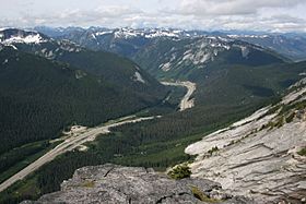
Southern approach to Coquihalla Summit as viewed from Yak Peak
|
|
| Elevation | 1,244 m (4,081 ft) |
| Traversed by | Highway 5 (Coquihalla Highway) |
| Location | British Columbia, Canada |
| Range | North Cascades |
| Coordinates | 49°35′50.3″N 121°04′41.3″W / 49.597306°N 121.078139°W |
The Coquihalla Summit is a high point on Highway 5 in British Columbia, Canada. It's like the top of a big hill on the highway. This summit is the highest spot on the road between the cities of Hope and Merritt.
You'll find it about 50 kilometers (31 miles) north of Hope. It's also about 65 kilometers (40 miles) south of Merritt. The summit is important because it divides the Coquihalla River and the Coldwater River. The road leading up to the Coquihalla Summit is very steep, especially if you are coming from the south.
Exploring Coquihalla Summit
The Coquihalla Summit is 1,244 meters (4,081 feet) high. It's a key part of the Coquihalla Highway, which stretches from Hope all the way to the Highway 1 interchange near Kamloops. The name "Coquihalla" comes from the local Indigenous language, Halq'emeylem. The word Kw'ikw'iya:la means "stingy container." This name refers to a special fishing rock. It was a good spot to catch salmon with spears.
Local stories say that skw'exweq, or "water babies," lived in a nearby pool. They would sometimes pull salmon off the spears. This meant only certain fishermen could catch fish there.
A Route Through History
The Coquihalla Valley has always been an important path. It connected the coast to the interior of British Columbia. In 1876, the Hope-Nicola Trail was built here. Later, the Kettle Valley Railway used this route from the early 1900s until 1961.
The modern Coquihalla Highway was built in phases. The first part, from Hope to Merritt, opened in 1986. This highway was a big project. It created an important link to the interior of British Columbia. Some parts of the old railway are now part of the Trans-Canada Trail. This includes the Othello Tunnels. These tunnels are a cool place to visit and see the old railway path.
Sometimes, heavy snow can cause problems on the highway. For example, in February 2014, a very large avalanche happened. It was about 33 kilometers (21 miles) north of Hope. It took three days to clear the snow and reopen the road.
Coquihalla Summit Recreation Area

The Coquihalla Summit Recreation Area is a special protected natural space. It is located right around the Coquihalla Summit. This area covers about 5,750 hectares (14,210 acres) of forested mountains. It stretches from Portia Peak to Coquihalla Lakes.
This recreation area was created in 1987. Its main goal is to protect the natural area. This area is where the wet coastal climate meets the drier interior climate. It's also a great place for travelers to enjoy nature. You can see beautiful granite peaks and wildlife. You can also spot historical features like the old Kettle Valley Railway and the original Coquihalla Highway route.
 | John T. Biggers |
 | Thomas Blackshear |
 | Mark Bradford |
 | Beverly Buchanan |

