Noire River (Bécancour River tributary) facts for kids
Quick facts for kids Noire River |
|
|---|---|

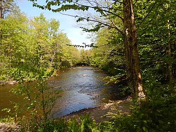
Rivière Noire dans le parc régional des Grandes-Coulées
|
|
| Native name | Rivière Noire |
| Country | Canada |
| Province | Quebec |
| Region | Centre-du-Québec |
| MRC | L'Érable Regional County Municipality |
| Physical characteristics | |
| Main source | Forested streams Sainte-Sophie-d'Halifax 183 m (600 ft) 46°17′58″N 71°33′35″W / 46.299316°N 71.559811°W |
| River mouth | Bécancour River Bécancour 104 m (341 ft) 46°18′19″N 71°52′15″W / 46.30528°N 71.87083°W |
| Length | 42.4 km (26.3 mi) |
| Basin features | |
| Progression | Bécancour River, St. Lawrence River |
| Tributaries |
|
The Noire River is also known as the Black River. It's a smaller river that flows into the Bécancour River. The Bécancour River then joins the mighty St. Lawrence River on its south side. The Noire River winds its way through several towns in Quebec, Canada, like Inverness, Laurierville, Plessisville (parish), and Notre-Dame-de-Lourdes. It's located in the L'Érable Regional County Municipality, which is part of the Centre-du-Québec region.
Contents
Where the Noire River Flows
The Noire River is surrounded by other rivers and waterways. Knowing these helps us understand its path.
- To the north, it's near the Bécancour River.
- To the east, it's also close to the Bécancour River.
- To the south, you'll find the McKenzie River, the Bécancour River, and the Gingras waterway.
- To the west, it's near the Bourbon River and the Bécancour River.
Starting Point of the River
The Noire River begins in the town of Inverness. Its source is about 1.9 kilometers (1.2 miles) southwest of the Bécancour River. It starts about 6.0 kilometers (3.7 miles) north of the center of Inverness village. It's also 9.1 kilometers (5.7 miles) east of the center of Laurierville village.
The River's Journey
The Noire River travels for about 42.4 kilometers (26.3 miles). Here's how its journey unfolds:
Upper Part of the River
- For the first 6.1 kilometers (3.8 miles), it flows northwest, then turns west. It reaches the border of Laurierville.
- It continues for 5.7 kilometers (3.5 miles) northwest, then west. It passes a bridge south of Laurierville village.
- Next, it flows 4.1 kilometers (2.5 miles) westward, going south of Laurierville. It then reaches the border of Plessisville (parish).
- It travels another 4.1 kilometers (2.5 miles) west. It reaches a bridge at the start of Kelly Lake, which the river crosses for 1.6 kilometers (1.0 mile) to the southwest.
Lower Part of the River
- After Kelly Lake, it flows 5.7 kilometers (3.5 miles) northwest. It makes a few loops, heading west and then east, until it reaches a road.
- It then goes 6.2 kilometers (3.9 miles) northwest, then north. It reaches the border of Notre-Dame-de-Lourdes.
- For 1.7 kilometers (1.1 miles), it flows northward until it meets the Perdrix River.
- It continues 0.7 kilometers (0.4 miles) northward to where the Barbue River joins it.
- Then, it flows 3.0 kilometers (1.9 miles) westward to the Route 265 bridge.
- Finally, it travels 5.1 kilometers (3.2 miles) westward until it joins the Bécancour River.
Where the River Ends
The Noire River empties into the south side of the Bécancour River. This meeting point is about 3.5 kilometers (2.2 miles) downstream from the Route 265 bridge in Notre-Dame-de-Lourdes. It's also 3.0 kilometers (1.9 miles) upstream from a small area called "Plage-Patry" and 5.4 kilometers (3.4 miles) upstream from where the Bourbon River joins.
What's in a Name?
The name "rivière Noire" means "Black River" in English. This name was officially recognized on December 5, 1968, by the Commission de toponymie du Québec. This commission is in charge of official place names in Quebec.
 | Janet Taylor Pickett |
 | Synthia Saint James |
 | Howardena Pindell |
 | Faith Ringgold |

