
Nordfriesland (district) facts for kids
Quick facts for kids
Nordfriesland
|
|||
|---|---|---|---|
|
|||
| Country | |||
| State | Schleswig-Holstein | ||
| Capital | Husum | ||
| Area | |||
| • Total | 2,047 km2 (790 sq mi) | ||
| Population
(2002)
|
|||
| • Total | 165,800 | ||
| • Density | 81.00/km2 (209.78/sq mi) | ||
| Time zone | UTC+1 (CET) | ||
| • Summer (DST) | UTC+2 (CEST) | ||
| Vehicle registration | NF | ||
| Website | nordfriesland.de | ||


Nordfriesland is a special area in the very north of Germany. It's a "district" (like a county) and is part of the state called Schleswig-Holstein. Imagine a place where the land meets the sea in a really unique way – that's Nordfriesland!
This whole coastal area is part of a huge nature park called the Schleswig-Holstein Wadden Sea National Park. This park is famous for its mudflats, which are muddy areas that appear when the tide goes out. In the south, there's a cool piece of land called the Eiderstedt peninsula. This is where the River Eider flows into the sea. Nordfriesland also includes many islands, known as the North Frisian Islands. There are five big ones like Sylt and Föhr, and ten smaller ones called Halligen. These Halligen are tiny islands that sometimes get flooded when the tide is very high!
Exploring the Coast and Islands
Nordfriesland's coast is a truly special place. It's home to the Wadden Sea, which is a UNESCO World Heritage site. This means it's recognized as super important for nature around the world. When the tide is low, you can walk across the mudflats, but only with a guide because it can be dangerous! Many unique animals and plants live here, especially birds that stop to feed during their long migrations.
The islands off the coast are popular for holidays. Sylt is the largest and most famous, known for its long sandy beaches. Föhr and Amrum are also beautiful, offering a quieter escape. The smaller Halligen are very unique. People live on them in houses built on small hills, so they stay dry even when the sea covers the rest of the island. Life on a Hallig is very close to nature and the sea.
Towns and Communities
Nordfriesland has several towns and many smaller communities. The capital of the district is Husum. It's a charming town with a harbor and a rich history. Other important towns include Friedrichstadt, known for its canals and Dutch-style buildings, and Tönning, which also has a historic harbor.
The smaller communities are organized into groups called "Ämter." These Ämter help manage local services for several villages together. For example, the Eiderstedt Amt includes towns like Sankt Peter-Ording, which is famous for its wide beach and stilt houses. The Föhr-Amrum Amt covers the communities on those islands, including Wyk auf Föhr. There are many small, friendly villages scattered across the mainland and islands, each with its own character and history.
Images for kids
-
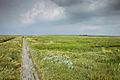
Marshland in Eiderstedt, typical of the North Frisian coast
-
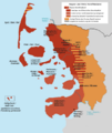
North Frisia within the modern Nordfriesland district.
-

A map showing the Nordfriesland district.


See also
 In Spanish: Distrito de Frisia Septentrional para niños
