Normansville, New York facts for kids
Quick facts for kids
Normansville
|
|
|---|---|
|
Former hamlet
|
|
| Etymology: Normansville was situated in the ravine created by the Normans Kill Creek. | |
| Country | United States |
| State | New York |
| Region | Capital District |
| County | Albany |
| Time zone | UTC-5 (EST) |
| • Summer (DST) | UTC-4 (EDT) |
| ZIP Code |
12054 (Bethlehem side)/12209 (Albany side)
|
| Area code(s) | 518 |
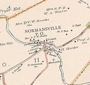
Normansville was a small community, or hamlet, in Albany County, New York. It was located in a deep valley, or ravine. This valley was carved by the Normans Kill Creek. This creek is a branch of the Hudson River. In the 1800s, Normansville was part of the town of Bethlehem.
Contents
History of Normansville
Normansville was first known as Upper Hollow. This name came from the deep valley where it was located. Another nearby area, downstream, was called Lower Hollow. It later became Kenwood.
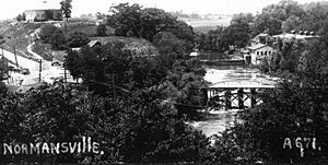
Upper Hollow started in 1805. This was when the Delaware Turnpike was built. This road connected the City of Albany to Otego. The Turnpike crossed the Normans Kill creek. A long wooden bridge, about 100 feet (30 meters) long, was built for this purpose. "Kill" is an old Dutch word for "stream." There was also a toll gate near the bridge.
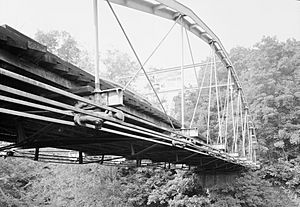
In 1869, a big flood, called a freshet, washed away the wooden bridge. The town of Bethlehem then built a new iron bridge.
Early Industries and Changes
After the Turnpike was built, businesses grew in Normansville. Taverns and factories used the water power from the Normans Kill. There were cloth mills and saw mills. Many of these mills were also destroyed by the 1869 flood. But they were quickly rebuilt. By the early 1900s, most of these mills were no longer used.
Another important business was the ice trade. In winter, large blocks of ice were cut from the Normans Kill. This ice was stored and then shipped to places like New York City. People used the ice in their iceboxes. The Pappalau Ice House was one of many ice houses. It was on the north side of the creek. By 1920, the ice trade ended. New technologies, like refrigerators, made it unnecessary.
Dividing the Community
In 1910, the border between Albany and Bethlehem changed. It moved south to the Normans Kill. This split Normansville into two parts. One part was in Albany, and the other was in Bethlehem.
Before this change, children in Normansville went to a small school. It was Bethlehem District Number 11. After the split, children in the Albany part went to Albany city schools. Children still in Bethlehem continued at District 11. Because of the split, District 11 lost many taxpayers. So, in 1919, it joined with a nearby school district.
New Roads and Bridges
In 1929, Delaware Avenue was changed. A new, higher bridge was built. It was called the Normanskill Viaduct. This bridge went over the Normans Kill valley. It allowed people to travel between Bethlehem and Albany. They no longer had to drive down into the Normansville valley.
In the 1980s and 1990s, more changes happened.
- In 1986, the old yellow brick turnpike was paved over.
- In 1987, the Rockefeller Road Bridge was closed for safety.
- In 1990, the Old Normans Kill Bridge was closed to cars. It remained open for people walking.
- In the 1990s, the Normanskill Viaduct was taken down. A new bridge was built nearby.
Normansville's Geography
Normansville was located in a deep valley. This valley was created by the Normans Kill creek. The creek forms the border between Albany (to the north) and Bethlehem (to the south). The valley walls are made of clay. The creek flows over a bed of flat rock called slate.
Important Landmarks

- Steven's Farm: Also known as Normanskill Farm, this is a park and working farm. It is owned by the City of Albany. It has the largest community gardens in Albany. There is also a dog park, hiking trails, and old farm buildings. The Albany Mounted Police Unit keeps its horses here. Ducks and geese from Washington Park stay here in winter. A historic whipple truss bridge from 1867 is also on the farm.
- The Old Normans Kill Bridge: This is the first bridge built across the Normans Kill. It was built in 1884. The bridge is 158 feet (48 meters) long. It is paved with yellow bricks. It is just wide enough for two cars to pass. Some local stories say that Edgar Allan Poe wrote about these yellow bricks. Then, L. Frank Baum might have used this idea in The Wonderful Wizard of Oz. However, historians say this story is not confirmed. The bridge was closed to cars in 1990. But people can still walk across it.
 | Selma Burke |
 | Pauline Powell Burns |
 | Frederick J. Brown |
 | Robert Blackburn |


