North Fork Bull Run River facts for kids
Quick facts for kids North Fork Bull Run River |
|
|---|---|

Bull Run River watershed
|
|
|
Location of the mouth of the North Fork Bull Run River in Oregon
|
|
| Country | United States |
| State | Oregon |
| County | Multnomah County |
| Physical characteristics | |
| Main source | Mount Hood National Forest Palmer Lake, Multnomah County, Oregon 45°33′52″N 121°59′47″W / 45.56444°N 121.99639°W |
| River mouth | Bull Run River Bull Run Reservoir 1, Multnomah County, Oregon 1,096 ft (334 m) 45°29′38″N 122°02′06″W / 45.49389°N 122.03500°W |
| Length | 6 mi (9.7 km) |
| Basin features | |
| Basin size | 8.32 sq mi (21.5 km2) |
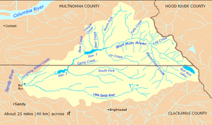
The North Fork Bull Run River is a small river, about 6 miles (10 km) long, in Oregon, United States. It flows into the Bull Run River. This river is super important because it helps provide clean drinking water for the city of Portland. It flows south through a special, protected area of the Mount Hood National Forest in Multnomah County. Finally, it meets the Bull Run River at a place called Bull Run Reservoir 1.
Where the River Flows
The North Fork Bull Run River starts at Palmer Lake, which is a bit southeast of Palmer Peak. From there, it flows south and a little to the west. It travels through Multnomah County and the Mount Hood National Forest. This area is part of the Bull Run Watershed Management Unit, which is a protected zone.
As the river flows, it picks up water from smaller streams that don't have names. One of these streams joins from the right side as the river goes through Latourell Prairie. Another unnamed stream joins from the left side just before the North Fork reaches Bull Run Reservoir 1. This reservoir is a big part of the main Bull Run River. The North Fork Bull Run River doesn't have any named streams flowing into it.
How Much Water Flows?
Since 1965, scientists have been measuring how much water flows in the North Fork Bull Run River. They use a special tool called a stream gauge right where the river meets the reservoir.
On average, between 1965 and 2007, about 72.6 cubic feet (2.06 cubic meters) of water flowed past this point every second. This measurement comes from an area of about 8.32 square miles (21.5 km2) that drains into the river.
The most water ever recorded flowing was 9,700 cubic feet (270 cubic meters) per second on January 20, 1972. This huge amount was probably caused by a sudden rush of water from a landslide. The least amount of water recorded was 8.6 cubic feet (0.24 cubic meters) per second, which happened between October 19 and 29, 1987.
The River's Home (Watershed)
A watershed is like a giant bowl where all the rain and snow that falls eventually drains into a specific river or lake. The Bull Run River watershed, which includes the North Fork Bull Run River, covers a huge area of about 139 square miles (360 km2).
This entire basin is super important because it's the main source of drinking water for the city of Portland. Because of this, the area is mostly used for things like collecting water, storing it, treating it, and managing the forests.
The North Fork Bull Run River's own basin is about 8.32 square miles (21.5 km2). This means it makes up about 6 percent of the entire Bull Run River watershed. Both the Portland Water Bureau and the United States Forest Service work together to manage and protect this vital water source.
 | Chris Smalls |
 | Fred Hampton |
 | Ralph Abernathy |


