
North Thormanby Island facts for kids

North Thormanby Island is a beautiful island located off the Sunshine Coast in British Columbia, Canada. It's about 17 kilometers (10.5 miles) west of the town of Sechelt. This island is a popular spot for people who love sandy beaches and boating.
Contents
Exploring North Thormanby Island
North Thormanby Island is part of the Gulf Islands in British Columbia, Canada. It's famous for its lovely sandy beaches. Many small boats like to anchor here while exploring the Strait of Georgia.
At low tide, you can actually walk all the way around the island on the beach! This is allowed because the "foreshore" (the part of the beach between high and low tide) is not private property. It's open for everyone to enjoy.
Cool Places to See Around the Island
There are several interesting spots near North Thormanby Island:
- Buccaneer Bay: A popular bay on the island.
- Buccaneer Bay Park: Found at Grassy Point, which is the southern tip of North Thormanby. At high tide, North and South Thormanby islands are separate.
- Water Bay: Located on South Thormanby Island.
- Smuggler Cove Marine Park: A park on the mainland nearby.
- Simson Marine Park: Another park found on South Thormanby Island.
- Frenchmans Cove: A cove on the mainland.
A Look Back at Thormanby's History
The first European explorer to visit Thormanby Island was Jose Maria Narváez. He arrived on July 12, 1791, and named the island "Isla de San Ignacio."
How the Island Got Its Name
The name "Thormanby" was given to the island by Captain George Richards in 1860. He was mapping the area with his ship, the Plumper. The island was named after a horse called Thormanby. This horse won a very famous horse race called the Epsom Derby in the same year. You'll find several other places in the area also named after things from the Epsom Derby!
Early Days and Resorts
For a long time, the island was covered in forests and no one lived there. That changed in 1905 when John William (Jack) Vaughan built the first cabin and a dock.
During World War One, Vaughan sold part of the island to a telephone company. They built a small vacation spot there with boats, a lodge, and cabins. After the war, in 1919, Vaughan bought it back. He opened it as a public resort in 1923. A company called the Union Steamship Company even offered daily boat service to the island!
Growing Communities and Changes
In the 1930s, more vacation cottages were built along Vaucroft Beach, which is on the Buccaneer Bay side of the island.
The Union Steamship Company stopped its service to Thormanby in 1946. After that, some of the very old, tall trees on the island were cut down for logging. Starting in the late 1960s, the island slowly began to be divided into smaller pieces of land for people to buy as vacation properties.
Today, the main dock on North Thormanby Island is called the Vaucroft port facility. The local government, the Sunshine Coast Regional District, has managed this dock since 2001.
Parks and Connections
On the southern tip of the island, you'll find Buccaneer Bay Provincial Park. At the northern end of the island is a small community called Vaucroft Beach. North Thormanby Island is also connected to South Thormanby Island.
Images
-
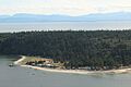
Vaucroft Beach

