
Ocale facts for kids
Ocale was the name of an old town in Florida that was visited by the Hernando de Soto expedition. It was also the name of a powerful group of Timucua people, who were Native Americans living in Florida.
The town of Ocale was probably located near the Withlacoochee River when de Soto visited. Later, the town might have moved closer to the Oklawaha River.
Contents
What's in a Name?
Like many places the Spanish explored in Florida, the area, its main town, and its chief all shared the same name: Ocale. However, the people who wrote about de Soto's trip spelled the name in different ways.
- De Soto's secretary, Rodrigo Ranjel, wrote "Ocale."
- Luys Hernandez de Biedma, who worked for the King, called it "Etocale."
- Another writer, the Gentleman of Elvas, simply called it "Cale."
- Garcilaso de la Vega used "Ocali" or "Ocaly."
Other old maps and records show names like "Olagale" and "Eloquale." The word "Eloquale" might have meant "song or singer of admiration" in the Timucuan language. "Elo" meant "to sing" or "singer," and "Quale" meant "wonder" or "admiration."
De Soto's Visit to Ocale
When Hernando de Soto first landed in Tampa Bay, he sent a group to a place called Urriparacoxi. The chief there told them that Ocale was a very large town with lots of turkeys, tame deer, and even gold, silver, and pearls! De Soto decided he wanted to make Ocale his camp for the winter.
De Soto and his men started their journey to Ocale on July 15, 1539. They reached the edge of the Ocale area, near a swamp, by July 24. It took them several days to find a way through the swamp and cross the River of Ocale, which was the Withlacoochee River.
The expedition arrived in Ocale at the end of July 1539 and stayed there through August. The first village they found in Ocale Province was called Uqueten. By July 29, the main group reached the town of Ocale itself. One writer said Ocale was small, but another, Garcilaso de la Vega, claimed it had 600 houses!
De Soto's army found some food like maize (corn), beans, and small dogs, but it wasn't enough for long. So, they raided a nearby area called Acuera for more food. Acuera was about two days' travel east of Ocale. While in Ocale, de Soto's men managed to gather enough corn to last for three months. They also had several small fights with the local people while collecting food.
De Soto's entire army stayed in Ocale for two weeks. After that, de Soto moved on with about one-third of his men, leaving the rest behind for another two and a half weeks. From Ocale, de Soto traveled to a town called Itara, and then to Potano, which was the main town of the Potano people.
The Ocale Province
Historians believe the Ocale Province was located in central Florida. Some think it was south of Alachua County and west of the Ocala forest, stretching to the Withlacoochee River. Others suggest it was a smaller area right along the Withlacoochee River, including parts of what are now Citrus, Marion, and Sumter counties.
The de Soto expedition only recorded two or three towns in Ocale Province: Uqueten, Ocale itself, and possibly Itara. Researchers think Uqueten might have been in northwestern Sumter County, and Ocale about 17 miles northeast, in southwestern Marion County. The town of Potano has been found near Orange Lake in northern Marion County. Itara was likely between Ocale and Potano, near Kendrick in the middle of Marion County.
The Ocale people were part of the western Timucua people. They may have spoken a dialect of the Timucua language similar to the Potano people.
Archaeologists have found evidence of early Spanish contact at some sites in the Ocale area. For example, at Tatum Mound, a burial site, some bones showed signs of possible sword wounds. This could be evidence of the fights de Soto's men had with the Ocale. Later, many people were buried in the mound quickly, possibly due to a disease like an epidemic. Many European items, like beads, have also been found at Tatum Mound, some of which are only found at places de Soto was known to have visited.
Later History of Ocale
The name "Eloquale," which seems to be a different spelling of Ocale, appeared on a map from the 1560s. It was shown west of the St. Johns River.
The Ocale people appear again in Spanish records in 1597. At that time, the chief of Ocale, along with other important Native American leaders, "rendered obedience" to the Spanish in St. Augustine. This meant they agreed to follow Spanish rules.
A Spanish mission called San Luis de Eloquale was built by 1630. Some think this mission was near the Withlacoochee River, while others place it on the Oklawaha River. It's possible that Eloquale was the Ocale town after it had moved. San Luis de Eloquale was not mentioned in later lists of missions and disappeared from Spanish records after 1655.
Images for kids
-
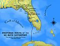
Route of the de Soto Expedition through Florida.

