
Tampa Bay facts for kids
Quick facts for kids Tampa Bay |
|
|---|---|

Tampa Bay from a NASA satellite in 2006
|
|

Tampa Bay
Location in Florida
|
|
| Coordinates | 27°45′45″N 82°32′45″W / 27.76250°N 82.54583°W |
| Type | harbor, estuary |
| Primary outflows | Gulf of Mexico |
| Managing agency |
|
Tampa Bay is a large natural harbor and shallow estuary (a place where fresh and salt water mix). It connects to the Gulf of Mexico on the west-central coast of Florida. Tampa Bay is actually made up of several smaller bays, like Hillsborough Bay and Old Tampa Bay. The biggest river flowing into the bay is the Hillsborough River. Many other smaller rivers and streams also feed into it.
For thousands of years, people lived along the shores of Tampa Bay. These included the Weedon Island Culture and later the Safety Harbor culture. They got most of their food from the bay, which was so full of life that they didn't even need to farm. When Spanish explorers arrived in the early 1500s, the Tocobaga people were likely the main group living there. Sadly, diseases and wars brought by the Europeans greatly reduced the native population by the late 1600s. For over a century, no one lived permanently in the area. In 1821, the United States took control of Florida. They built Fort Brooke near the Hillsborough River in 1824.
Over the 20th century, the communities around Tampa Bay grew a lot. Today, about 4 million people live here. This means Tampa Bay is used a lot for business and fun activities. However, it also means more pollution from factories, farms, sewage, and surface runoff (water flowing over land). By the early 1980s, the bay's water quality was very bad. This caused a big drop in sea life and made it harder to use the bay for recreation. In recent years, people have worked hard to clean up Tampa Bay. They have improved sewage treatment and started projects to bring back sea grass. This has made the water much cleaner. But sometimes, harmful red tide and other algae blooms still happen, which worries people about the bay's health.
The name "Tampa Bay" is often used to talk about the whole Tampa Bay area. This area includes many towns and cities in several counties around the bay. Local groups, sports teams, and tourism boards often use "Tampa Bay" in their names. This can make people think it's the name of a city, but it's actually the name of the body of water.
Exploring Tampa Bay's Geography

How Tampa Bay Was Formed
Tampa Bay was created about 6,000 years ago. It formed as a brackish (mixed fresh and salt water) drowned river valley. It has a wide opening that connects it to the Gulf of Mexico. Before that, it was a large fresh water lake. This lake might have been fed by the Floridan Aquifer through natural springs. Scientists believe that rising sea levels after the last ice age helped create a huge sink hole. This sinkhole near the bay's current mouth connected the lake to the gulf.
Wildlife and Nature in Tampa Bay
Tampa Bay is Florida's largest open-water estuary. It covers over 400 square miles (1,036 square kilometers). Its shores touch Hillsborough, Manatee, and Pinellas counties. More than a hundred small streams and rivers feed into the bay. The Hillsborough River is the largest. Other big rivers include the Alafia, Manatee, and Little Manatee rivers. Because of all these rivers, the bay's large watershed (the land area that drains into it) covers parts of five Florida counties. It is about 2,200 square miles (5,700 square kilometers) in size.
The bottom of Tampa Bay is mostly silty and sandy. The water is quite shallow, averaging only about 12 feet (3.7 meters deep). This shallow water and the tidal mud flats (muddy areas exposed at low tide) are perfect for large sea grass beds. Along with the surrounding mangrove wetlands, the bay is home to many different kinds of wildlife. Over 200 types of fish live in the bay's waters. You can also find bottlenose dolphins and manatees here. Many marine invertebrates (animals without backbones) like oysters, scallops, clams, shrimp, and crabs also call the bay home.
More than two dozen types of birds live along the bay's shores and small islands all year. These include brown pelicans, herons, egrets, Roseate spoonbills, cormorants, and laughing gulls. Other migratory species visit in the winter. During the cooler months, warm water from power plants near the bay attracts many West Indian manatees. These gentle giants are an endangered species.
Protecting Tampa Bay's Environment
Conservation Efforts
In 1990, the United States Environmental Protection Agency called Tampa Bay an "estuary of national significance." This means it's very important to protect. Two National Wildlife Refuges are located in Tampa Bay: Pinellas National Wildlife Refuge and the refuge on Egmont Key. Most of the islands and sandbars in the bay are off-limits to people. This is because they have fragile ecosystems and are important nesting spots for many bird species. The Tampa Bay Estuary Program works to keep the bay healthy.
Dealing with Pollution
Tampa Bay used to be full of fish and wildlife. The Safety Harbor culture people lived almost entirely on food from the sea. Even in the early 1900s, people reported seeing huge schools of mullet (a type of fish) that were so many they "impeded the passage of boats."
But as communities grew quickly in the 20th century, the bay's environment was badly damaged. Too much fishing, constant dredging (digging up the bay bottom for shipping channels), and cutting down mangroves for building all hurt the bay. The biggest problem was dirty water and other pollutants flowing into the bay. This made the water quality much worse. The bay was at its worst in the 1970s. The water was so cloudy that sunlight couldn't reach the bottom. This reduced sea grass by over 80% and severely harmed marine life. Many common species became rare, and bay beaches were often closed due to unsafe bacteria levels.
Starting in the early 1980s, new laws helped improve water quality. Better water treatment plants were built. Rules for industrial discharge (waste from factories) became stricter. This led to slow but steady improvements in the bay's health. By 2010, sea grass, water clarity, and biodiversity (the variety of life) were back to levels seen in the 1950s.
However, pollution from farms, factories, and developed areas still threatens the bay. This pollution can make the water cloudy with sediments and algae blooms. Sea grass coverage even dropped a little in the late 2010s. Wastewater from old phosphate plants near the shore has been a big problem. For example, in 2004, a leak from a Cargill phosphate plant spilled 65 million gallons of acidic water. This badly damaged wetlands nearby. In April 2021, a leak at the closed Piney Point phosphate plant sent over 200 million gallons of nutrient-rich waste into the bay. This caused a huge red tide bloom, killing over 1,000 tons of fish. It may also harm sea grass beds further.
How Climate Change Affects Tampa Bay
Tampa Bay, like other parts of Florida, is very sensitive to sea level rise caused by climate change. The sea level has risen 8 inches (20 cm) since 1946. Tampa Bay is also one of the areas in the U.S. most at risk from hurricanes. This is because of its location, growing population, and the bay's shape.
The Tampa Bay Regional Resiliency Coalition helps coordinate the region's response to climate change. Cities like St. Petersburg and Tampa are changing their buildings and infrastructure to deal with rising sea levels.
People and History Around Tampa Bay

Early People of Tampa Bay
Humans have lived in Florida for at least 14,000 years. Back then, sea levels were much lower, and Florida's land stretched almost 60 miles (97 km) further west. Early people might have lived near Tampa Bay when it was still a freshwater lake. Evidence of these early inhabitants has been found about 10 miles (16 km) east of downtown Tampa.
The first clear signs of people living directly on Tampa Bay's shores are from the Manasota culture. They were part of the Weeden Island culture and lived here about 5,000–6,000 years ago. By then, sea levels had risen, and the bay was connected to the Gulf of Mexico. These people relied almost completely on the bay for food. Later, around 800 AD, the Safety Harbor culture took their place. The Tocobaga people, who are ancestors of today's Seminole and Miccosukee Tribes, were the main group living around Tampa Bay when Europeans first arrived.
European Explorers Arrive
The Safety Harbor culture was strong when Europeans first came in the mid-1500s. The Tocobaga people, whose main town was near today's Safety Harbor, had the most contact with Spanish explorers. The Spanish didn't find gold or silver and couldn't convert the native people to Christianity, so they didn't stay long. However, the diseases they brought greatly reduced the native population. This led to the collapse of most cultures in Florida. For almost 200 years, the Tampa Bay area was nearly empty of people.
Early mapmakers gave Tampa Bay different names. A Spanish map from 1584 called it Baya de Spirito Santo ("Bay of the Holy Spirit"). A 1695 map called it Bahia Tampa. Later maps from the late 1700s showed the bay divided. They used Tampa Bay for the western part and Hillsboro Bay for the eastern part, with the overall name Bay of Spiritu Santo. Sometimes, the whole bay was called The Bay of Tocobaga.
Under United States Control
The United States bought Florida from Spain in 1821. The name Spirito Santo soon disappeared from maps, replaced by "Tampa Bay." The U.S. built Fort Brooke in 1824. For the next few decades, during the Seminole Wars, Tampa Bay was a key place for conflicts. It was also where Seminole and Miccosukee people were held and forced to leave Florida. Fort Brooke and other military sites were part of the Trail of Tears in Florida.
Over the next 100 years, many new communities grew around the bay. Fort Brooke became Tampa. Fort Harrison became Clearwater. A trading post called "Braden's Town" grew into Bradenton. St. Petersburg also grew quickly after it was founded in the late 1800s. By 2010, the Tampa Bay Area was home to over 4 million people.
Getting Around Tampa Bay
Travel by Sea
In the mid-1800s, roads in central Florida were rough trails. There were no train lines yet. So, the easiest way to travel to and from Tampa was by sea. But by the late 1800s, Tampa Bay was too shallow for large, modern ships. Most big ships had to anchor far from shore. Smaller boats then carried cargo and passengers to and from the city.
Henry B. Plant's railroad line reached the area in 1884. He built the town and shipping center of Port Tampa at the end of his rail line. In 1898, Plant used his connections to make Port Tampa a major starting point for the U.S. Army during the Spanish–American War. This led the U.S. Congress to fund the first big dredging operation in Tampa Bay. A deep shipping channel was created, connecting Port Tampa to the bay's mouth. This allowed Plant to greatly expand his steamship business. In 1917, another channel was dredged to the Port of Tampa. This instantly made Tampa an important shipping center.
Today, the U.S. Army Corps of Engineers keeps over 80 miles (129 km) of deep-water channels in Tampa Bay. These channels are up to 47 feet (14 meters) deep. They must be constantly re-dredged because the bay bottom is sandy. While dredging helps sea trade, it has also harmed the bay's water quality and environment. In recent years, more care has been taken to reduce the environmental impact of dredging. The material dug up from dredging has also been used to create several islands. These islands have become important nesting sites for seabirds, including threatened species like oystercatchers. They are now "sanctuary islands" where boats are not allowed.
-
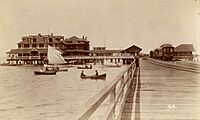
Tampa's waterfront, 1890.
-
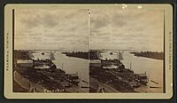
Port Tampa, c. 1900.
-
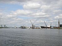
Facilities at Port Tampa Bay from Davis Islands, downtown Tampa at left

.jpg)

Major Ports on Tampa Bay
- Port Tampa Bay (called the Port of Tampa until 2014): This is the oldest port on Tampa Bay. It started with the wharves of Fort Brooke in the 1820s. Today, it's mainly east and southeast of downtown Tampa. It is the largest port in Florida and the 10th largest in the nation. Port Tampa Bay handles half of Florida's cargo, including bulk goods, vehicles, refrigerated items, and petroleum. It also has a large ship repair industry and several cruise ship terminals.
- Port Tampa: Established in 1885 by Henry B. Plant. It was at the end of his railroad line on the eastern shore of Old Tampa Bay. While it was important, the Port of Tampa became bigger in the early 1900s. Port Tampa is still important for receiving aviation fuel, which is piped to nearby Tampa International Airport and MacDill Air Force Base.
- Port Manatee: Located on the southern shore of Lower Tampa Bay. It has the most refrigerated dockside space of any port in the Gulf of Mexico. It ranks fifth among Florida's fourteen seaports in total annual cargo.
- The Port of St. Petersburg: Located on the St. Petersburg waterfront on Old Tampa Bay. It is operated by the city. This is the smallest of Florida's ports, mostly serving private boats. It is also home to a U.S. Coast Guard station.
Travel by Land

In the early 1900s, traveling by land between the growing communities around Tampa Bay was very hard. A trip between Tampa and St. Petersburg was almost 50 miles (80 km) around the north end of Old Tampa Bay. It could take up to 12 hours by train and over a full day by car on bad roads. The trip between St. Petersburg and Bradenton was even longer, over 70 miles (113 km) all the way around Tampa Bay. This trip still took about two hours into the 1950s.
In 1924, the Gandy Bridge was built over Old Tampa Bay. This reduced the driving distance between Tampa and St. Petersburg to just 19 miles (31 km). Ten years later, the Davis Causeway (now called the Courtney Campbell Causeway) was built between Clearwater and Tampa. More bridges were built across Tampa Bay over the years. This made travel between the communities much faster and helped the Tampa Bay area grow economically.
Bridges Crossing Tampa Bay
- Sunshine Skyway Bridge: Opened in 1954. It crosses Lower Tampa Bay from Bradenton in the south to St. Petersburg in the north. This greatly reduced travel times between Manatee and Pinellas Counties. It is part of I-275 and US 19.
- Gandy Bridge: Opened in 1924. This was the first roadway bridge over Tampa Bay. It crosses Old Tampa Bay from Tampa in the east to St. Petersburg in the west. It is part of U.S. Route 92.
- Howard Frankland Bridge: Opened in 1960. It crosses the middle of Old Tampa Bay from Tampa in the east to St. Petersburg in the west. It is part of I-275.
- Courtney Campbell Causeway: Opened in 1934. It crosses northern Old Tampa Bay from Tampa in the east to Clearwater in the west. It is part of Florida State Road 60.
- Bayside Bridge: Opened in 1993. It runs mostly parallel to the western shore of Old Tampa Bay. It goes from Largo / St. Petersburg in the south to Clearwater in the north. It was built to help reduce traffic on nearby US-19.
- 22nd Street Causeway: Opened in 1926. The bridge part crosses the mouth of McKay Bay near Port Tampa Bay. It is part of U.S. Route 41.
Travel by Air

Because it was so hard to travel between Tampa and St. Petersburg in the early 1900s, the world's first scheduled air service was created. This was the St. Petersburg-Tampa Airboat Line, which operated in 1914.
Even though bridges made air travel across the bay less necessary, several airports have been built along the shoreline. Albert Whitted Airport in St. Petersburg and Peter O. Knight Airport on Davis Island near downtown Tampa were both built in the 1930s. Later, Tampa International Airport and St. Pete–Clearwater International Airport were built on opposite sides of Old Tampa Bay. MacDill Air Force Base also opened on the southern tip of Tampa's Interbay Peninsula.
See also
 In Spanish: Bahía de Tampa para niños
