
Hillsborough River (Florida) facts for kids
Quick facts for kids Hillsborough River |
|
|---|---|
 |
|

Hillsborough River watershed
|
|
| Country | United States |
| State | Florida |
| Counties | Pasco, Hillsborough |
| District | SWFWMD |
| Cities | Temple Terrace, Tampa |
| Physical characteristics | |
| Main source | Green Swamp Branchborough, Florida 28°16′28″N 82°05′38″W / 28.27444°N 82.09389°W |
| River mouth | Hillsborough Bay Tampa, Florida 27°56′16″N 82°27′43″W / 27.93778°N 82.46194°W |
| Length | 60 mi (97 km) |
| Basin features | |
| Basin size | 740 sq mi (1,900 km2) |
| Tributaries |
|
The Hillsborough River is a river in Florida, United States. It starts in the Green Swamp. This is where Hillsborough, Pasco, and Polk counties meet. The river flows for about 60 miles (97 km) through Pasco and Hillsborough Counties. It ends in Tampa at Tampa Bay.
The river has four nature trails. These trails are over 7 miles (11 km) long. They are great for hikers. The name Hillsborough River first appeared on a British map in 1769. It was named after the Earl of Hillsborough. He was a British government official at that time.
Contents
History of the Hillsborough River
Scientists believe the Hillsborough River has been flowing for about 27,000 years. Humans likely first came to this area 12,000 to 15,000 years ago.
In the late 1700s, the land around the Hillsborough River was a thick, old forest. It had huge bald cypress and longleaf pine trees. Some of these trees were hundreds or even thousands of years old. From the mid-1800s to about 1913, people started cutting down these trees. Most trees in the river area are now less than 100 years old.
Cutting down the old trees changed the forest. New trees like water ash grew quickly in the sunny spots. The river swamp forest today looks very different from how it did thousands of years ago.
When Europeans first arrived in Florida, the Safety Harbor culture lived around Tampa Bay. Two groups, the Mocoso and Pohoy, lived near where the Hillsborough River meets Tampa Bay. Hernando de Soto landed nearby in 1539. He traveled through Mocoso on his way north. By the early 1700s, diseases and slavery had almost wiped out the Safety Harbor people.
Important Dates for the Hillsborough River
- 1757: A Spanish explorer named Don Francisco Maria Celi explored the river. He went up to the Temple Terrace area. He was looking for longleaf pine trees for ship masts. He named the pine forest "The Pines of the Cross of Saint Teresa." A plaque at Riverhills Park remembers his trip.
- 1772: A map sent to the Earl of Hillsborough showed the river named as the Hillsborough. Around this time, Native Americans from the north, mostly Creek people, moved to Florida. They became known as Seminoles.
- 1821: Florida became a United States territory.
- 1824: Construction of Fort Brooke began at the mouth of the Hillsborough River.
- 1828: The Fort King Military Road was built. It connected Fort King in Ocala to Fort Brooke in Tampa. A bridge was built over the Hillsborough River.
- 1830: The U.S. government passed the Indian Removal Act. They started trying to move the Seminole people from Tampa Bay to a reservation west of the Mississippi River. This caused tension.
- 1835: Seminoles burned the bridge at the Fort King Road crossing. Conflicts continued.
- 1836: Fort Foster was built at the river crossing. This protected an important spot.
- 1842: The Armed Occupation Act offered land to men who would build a house and farm for five years.
- 1843: The Jean Street Shipyard started on the Hillsborough River.
- 1846: The first ferry crossing on the river began. This helped Tampa grow on both sides of the river.
- 1861: During the American Civil War, federal troops blocked Tampa Bay. This stopped goods from moving in and out of Tampa.
- 1863: Federal troops went upriver near Lowry Park Zoo. They found and burned ships carrying cotton. This was the only Civil War fight on the Hillsborough River.
- 1891: The Tampa Bay Hotel, now the Henry B. Plant Museum, opened.
- 1897: An electrical dam was built on the river. It cost $150,000.
- 1898: On December 13, the dam was blown up by cattle owners. They were angry about losing grazing land. You can still see parts of the old dam when the water is low.
- 1898–99: TECO bought the electric company and built a new dam.
- 1899: Tampa's first water plant was built. It supplied water to the city.
- 1900: The Sulphur Springs property was developed and opened to the public.
- 1910: Hillsborough Bay was deepened for ships. The Hillsborough River area was heavily logged until 1913.
- 1911–1914: Bertha Potter Palmer bought a huge area of land along the river. She called it "Riverhills Ranch." It was a private hunting preserve.
- 1922: The Temple Terrace Golf and County Club opened.
- 1923: The city of Tampa built a water treatment plant. It used water from above the dam.
- 1933: A huge rainstorm washed away the Tampa Electric dam. TECO did not rebuild it.
- 1935: Hillsborough River State Park opened.
- 1944: The city of Tampa finished building the current dam. It holds drinking water for the city.
- 1961: The Southwest Florida Water Management District (SWFWMD) was created.
- 1960s-70s: The 14-mile (23 km) long Tampa Bypass Canal was built. It helps control floods.
- 1979: Swimming was stopped at Hillsborough River State Park. A swimming pool was built instead.
- 1982: Lettuce Lake Park opened on the river.
- 1988: The yearly Hillsborough River Cleanup began.
- 1991: Canoe Escape opened. Its owners helped people learn about the river.
- 1995: The Hillsborough River was named an Outstanding Florida Water. This means it is a special, protected waterway.
- 1995: The river was also named a Florida Recreational Canoe Trail.
- 1999: "Friends of the River" was formed. This group worked to protect the river's water flow.
- 2007: A plan was adopted to increase the river's water flow. This helps keep the river healthy.
The Hillsborough River Today
The Hillsborough River is home to many animals. Many large bird nesting areas are found here. Sixth-grade students in Hillsborough County visit the river. They learn about its ecosystem, watershed, and native Florida animals. This happens at a place called 'Nature's Classroom'.
The Hillsborough River dam creates a large lake. This lake covers 1,300 acres (5 km2) and holds 1.6 billion US gallons (6,100,000 m3) of water. This water supplies the City of Tampa. The city is allowed to take water from the river above the dam. This water is used for its citizens.
The Southwest Florida Water Management District protects and manages Florida's waters. They make sure the river has enough water. They also work to keep the middle and upper parts of the river clean and natural.
The river above the dam flows through the Temple Crest neighborhood. Above the 56th Street bridge, it flows through Temple Terrace. This is a very beautiful part of the river. The city cleans its part of the river twice a year.
Hillsborough River State Park
Hillsborough River State Park covers 2,990 acres (12 km2) along the river. It is in northeastern Hillsborough County. The park protects many Florida environments. These include swamps and oak forests. It also protects many endangered species. The park's goal is to keep "the real Florida" safe.
Visitors can picnic, camp, canoe, hike, fish, and swim in a pool. There is also a special spot to see the river's Class II rapids. This is one of the only rivers in Florida with rapids. The park opened in 1935. This makes it one of Florida's oldest state parks.
The Middle River: Tampa's Water Source
The middle river is the part of the river north of the dam. It is the main source of water for the City of Tampa. This section extends from the dam back to Fletcher Avenue. The Hillsborough River starts in the Green Swamp and flows into Tampa Bay.
In Tampa's early days, people got water from wells and tanks. Tampa's first water plant opened in 1899. It pumped well water for the city. In 1923, the city bought the water plant. The middle river has been Tampa's official water source since 1944.
But the middle river is more than just a water source. It is a rich and diverse ecosystem. Orange Lake, in the Temple Crest neighborhood, is a bird sanctuary. It is also a living wetland. Upstream, near Temple Terrace's Riverhills Park, you can see old Florida. Cypress trees stand tall in the watery landscape.
Fun Activities on the Hillsborough River
Florida has marked a 34.5-mile (55.5 km) canoe trail on the river. It starts at Hillsborough River State Park. It ends at Rowlett Park in Tampa. Many parks are located along the Hillsborough River. These include Morris Bridge Park, Trout Creek Wilderness Park, Lettuce Lake Park, Riverfront Park, Riverhills Park, Angel of Hope Park, Rogers Park, and Rivercrest Park.
River Crossings
| Crossing | Carries | Image | Location | Coordinates |
|---|---|---|---|---|
| Headwaters | 28°16′28″N 82°05′38″W / 28.27444°N 82.09389°W | |||
| 140024 |  |
Branchborough | 28°16′18″N 82°05′53″W / 28.27167°N 82.09806°W | |
| 140009 |  |
28°15′33″N 82°06′18″W / 28.25917°N 82.10500°W | ||
| CSX Rail Bridge | 28°14′09″N 82°06′59″W / 28.23583°N 82.11639°W | |||
| CSX Rail Bridge | 28°11′45″N 82°09′39″W / 28.19583°N 82.16083°W | |||
| 140007 | Buchman Highway |
.JPG) |
Corvilla | 28°11′35″N 82°09′54″W / 28.19306°N 82.16500°W |
| 144002 | Crystal Springs Road |  |
Crystal Springs | 28°11′09″N 82°11′03″W / 28.18583°N 82.18417°W |
| Where Blackwater Creek joins | Thonotosassa | 28°09′03″N 82°12′56″W / 28.15083°N 82.21556°W | ||
| Former ACL Railroad Bridge | Tampa and Thonotosassa Railroad | Fort Foster | ||
| 100434 |  |
28°09′00″N 82°13′16″W / 28.15000°N 82.22111°W | ||
| Where New River joins | Hillsborough River State Park |
|||
| Where Flint Creek joins | 28°04′58″N 82°17′07″W / 28.08278°N 82.28528°W | |||
| Morris Bridge 100026 |
Morris Bridge Road |
 |
Pine Ridge Estates | 28°05′55″N 82°18′41″W / 28.09861°N 82.31139°W |
| Water control structure | Hillsborough River SP Main Trail | Temple Terrace | 28°05′18″N 82°21′06″W / 28.08833°N 82.35167°W | |
| 100387/100388 | 28°05′14″N 82°21′14″W / 28.08722°N 82.35389°W | |||
| 100276 | Fletcher Avenue |
 |
28°04′09″N 82°22′38″W / 28.06917°N 82.37722°W | |
| 100084/100402 | Fowler Avenue |
 |
28°03′15″N 82°21′51″W / 28.05417°N 82.36417°W | |
| 104143/104144 | Temple Terrace Highway/Bullard Parkway |
 |
28°01′57″N 82°22′54″W / 28.03250°N 82.38167°W | |
| Tampa Bypass Canal | 28°01′05″N 82°22′32″W / 28.01806°N 82.37556°W | |||
| 56th Street Bridge 100267/100268 |
N 56th Street |
 |
28°01′28″N 82°23′36″W / 28.02444°N 82.39333°W | |
| 40th Street Bridge 104504 |
N 40th Street |
 |
Del Rio | 28°00′34″N 82°24′53″W / 28.00944°N 82.41472°W |
| Hillsborough River Dam | Tampa | 28°01′27″N 82°25′42″W / 28.02417°N 82.42833°W | ||
| Rowlett Park Drive Bridge 100086 |
Rowlett Park Drive |  |
28°01′19″N 82°26′06″W / 28.02194°N 82.43500°W | |
| CSX Rail Bridge |  |
28°01′19″N 82°26′07″W / 28.02194°N 82.43528°W | ||
| Former Van Dyke Street Bridge | Van Dyke Street (now North and South Van Dyke Place) |  |
||
| Nebraska Avenue Bridge 100001 |
Nebraska Avenue |
 |
28°01′12″N 82°27′04″W / 28.02000°N 82.45111°W | |
| 100217/100218 |  |
28°01′13″N 82°27′19″W / 28.02028°N 82.45528°W | ||
| James N. Holmes Bridge 100069 |
 |
28°01′16″N 82°27′34″W / 28.02111°N 82.45944°W | ||
| Sumter L. Lowry Bridge 105602 |
Sligh Avenue |  |
28°00′38″N 82°27′54″W / 28.01056°N 82.46500°W | |
| Hillsborough River Bridge (drawbridges) 100618/100920 |
Hillsborough Avenue |
 |
27°59′46″N 82°27′56″W / 27.99611°N 82.46556°W | |
| Paul H. Smith Bridge 100500 |
Dr. Martin Luther King Jr. Boulevard |
 |
27°58′53″N 82°28′32″W / 27.98139°N 82.47556°W | |
| Columbus Drive Swing Span 105504 |
Columbus Drive |  |
27°58′00″N 82°28′30″W / 27.96667°N 82.47500°W | |
| Eugene Holtsinger Bridge 105600 |
North Boulevard |  |
27°57′37″N 82°28′05″W / 27.96028°N 82.46806°W | |
| 100135/100136 |  |
27°57′23″N 82°27′52″W / 27.95639°N 82.46444°W | ||
| Fortune Street Bridge (drawbridge) 105503 |
Laurel Street |  |
27°57′16″N 82°27′54″W / 27.95444°N 82.46500°W | |
| Cass Street Drawbridge 105502 |
Cass Street |  |
27°57′01″N 82°27′54″W / 27.95028°N 82.46500°W | |
| CSX Rail Bridge |  |
27°57′00″N 82°27′54″W / 27.95000°N 82.46500°W | ||
| Kennedy Drawbridge 100100 |
Kennedy Boulevard |
.jpg) |
27°56′48″N 82°27′40″W / 27.94667°N 82.46111°W | |
| Brorein Street Drawbridge 105501 |
Brorein Street |  |
27°56′36″N 82°27′32″W / 27.94333°N 82.45889°W | |
| Crosstown Viaduct 100332/100333 |
Lee Roy Selmon Expressway |
27°56′35″N 82°27′32″W / 27.94306°N 82.45889°W | ||
| Platt Street Drawbridge 105550 |
Platt Street |  |
27°56′30″N 82°27′30″W / 27.94167°N 82.45833°W | |
| Where Seddon Channel and Garrison Channel join | 27°56′26″N 82°27′30″W / 27.94056°N 82.45833°W | |||
| Plant Street Bridge 105606 |
Davis Boulevard Plant Avenue |
27°56′17″N 82°27′42″W / 27.93806°N 82.46167°W | ||
| Hyde Park Avenue Bridge 105625 |
Davis Boulevard Hyde Park Avenue |
27°56′13.8″N 82°27′44.2″W / 27.937167°N 82.462278°W | ||
| Mouth | 27°56′16″N 82°27′43″W / 27.93778°N 82.46194°W | |||
Images for kids
-
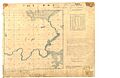
Survey of the middle Hillsborough River in 1843
-
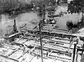
The original dam under construction in 1897
-
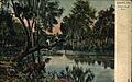
Postcard view of the Hillsborough River in 1910
-
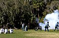
Seminole War reenactors at Hillsborough River State Park
-
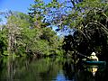
Paddling on the Hillsborough River
-
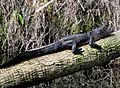
An Alligator snoozing in the sun
-
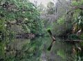
Paddling the Hillsborough River


