Manatee County, Florida facts for kids
Quick facts for kids
Manatee County
|
|||
|---|---|---|---|
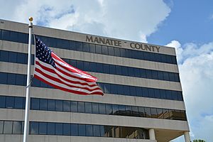
Manatee County Administration Building
|
|||
|
|||
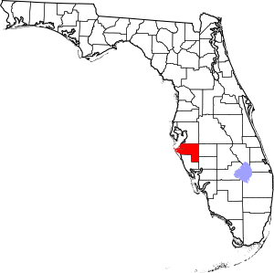
Location within the U.S. state of Florida
|
|||
 Florida's location within the U.S. |
|||
| Country | |||
| State | |||
| Founded | January 9, 1855 | ||
| Named for | Florida manatee | ||
| Seat | Bradenton | ||
| Largest city | Bradenton | ||
| Area | |||
| • Total | 893 sq mi (2,310 km2) | ||
| • Land | 743 sq mi (1,920 km2) | ||
| • Water | 150 sq mi (400 km2) 16.8% | ||
| Population
(2020)
|
|||
| • Total | 399,710 | ||
| • Density | 538/sq mi (208/km2) | ||
| Time zone | UTC−5 (Eastern) | ||
| • Summer (DST) | UTC−4 (EDT) | ||
| Area code | 941 | ||
| Congressional district | 16th | ||
Manatee County is a county located in the state of Florida, United States. In 2020, about 399,710 people lived here. It is part of the larger North Port-Bradenton-Sarasota area.
The main city and county seat is Bradenton. Manatee County was created in 1855. It was named after the Florida manatee, which is Florida's official marine mammal. Important features of the county include parts of the Tampa Bay estuary, the Sunshine Skyway Bridge, and the Manatee River.
Contents
History of Manatee County
Ancient Times
For thousands of years, Native Americans lived in the area that is now Manatee County. Scientists have found old tools and shell piles at places like Terra Ceia and Perico Island. These discoveries show that people from the Woodland period lived here.
European Explorers and Early Settlers
Some historians think that the De Soto Expedition landed near the southern part of the Manatee River.
During the Patriot War and First Seminole War, many Native Americans and African Americans sought safety in Florida. Some of them settled in what is now Manatee County. They built a settlement called Angola along the Manatee River. By 1819, Angola might have had as many as 600 to 700 people.
In 1842, the area was opened for new settlers. This happened after a law called the Armed Occupation Act was passed. One early group was the Manatee Colony, led by Colonel Samuel Reid. It included 31 people, both Black and White.
Joseph and Hector Braden were also important early settlers. They moved to the Manatee River area in 1842. They had lost their land in North Florida during a financial crisis. The brothers heard that there was plenty of land here. They built a log cabin five miles north of the Manatee River's mouth.
Four years later, Hector drowned in the Manatee River during a hurricane. Despite this, Joseph decided to build the Braden sugar mill. It was located where the Manatee River and the Braden River meet. He also built a dock and a fortified area near his home. In 1851, he built the Braden Castle, a home made of a strong material called tabby.
In 1856, the fortified home was attacked during the Third Seminole War. Later, in the early 1900s, Braden Castle became a popular place for tourists. Joseph Braden lived there for six years before moving to Tallahassee.
How the County Grew
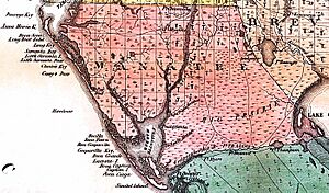
Manatee County was formed from a large part of Hillsborough County in January 1855. Florida Senate President Hamlin V. Snell helped create it. The new county was huge, covering 5,000 square miles. It included all of what are now Charlotte County, DeSoto County, Glades County, Hardee County, Highlands County, Sarasota County, and part of Lee County.
The first county seat was a village called Manatee. It was on the southern shore of the Manatee River, in what is now eastern Bradenton. In 1866, the county seat moved to Pine Level. This change was decided by a vote.
In 1887, the county seat moved again. This happened because DeSoto County was created from parts of Manatee County. Braiden Town, which is now Bradenton, was chosen as the new county seat. Most people lived near the Manatee River, so they voted for Bradenton. In 1921, Sarasota County was created. This made Manatee County its current size.
The American Civil War Years
After the Seminole Wars, Manatee County continued to grow. Its economy also got stronger. People raised cattle, hogs, and sheep. They also made and sold sugar and molasses.
During the American Civil War, Manatee County sent supplies to the Confederate army. The Union army tried to stop these supplies. For example, in August 1864, the Union ship USS Stonewall raided the Manatee River. Some records say Dr. Braden's sugar works were destroyed. Other records say his property was not touched.
At least 100 men from Manatee County joined the Confederate army. Some of these men were part of the 7th Florida Infantry Regiment. This group fought in the Army of Tennessee.
The Gamble Plantation is in Manatee County. It was a sugar plantation and the home of Major Robert Gamble. After the Civil War, some believe that Judah P. Benjamin, a Confederate leader, hid at the mansion before escaping to England.
Geography
Manatee County covers about 893 square miles. About 743 square miles are land, and 150 square miles (17%) are water.
Neighboring Counties
- Hillsborough County – to the north
- Polk County – to the northeast
- Hardee County – to the east
- DeSoto County – to the southeast
- Sarasota County – to the south
Protected Natural Areas
Manatee County has several important natural and historical sites:
- De Soto National Memorial
- Passage Key National Wildlife Refuge
- Lake Manatee State Park
- Terra Ceia Preserve State Park
- Myakka River State Park
- Madira Bickel Mound State Archaeological Site
- Beker-Wingate Creek State Park
Rivers and Lakes
- Manatee River
- Wares Creek
- Braden River
- Gamble Creek
- Bowlees Creek
- Ward Lake
- Lake Parrish
- Lake Manatee
Population Facts
| Historical population | |||
|---|---|---|---|
| Census | Pop. | %± | |
| 1860 | 854 | — | |
| 1870 | 1,931 | 126.1% | |
| 1880 | 3,544 | 83.5% | |
| 1890 | 2,895 | −18.3% | |
| 1900 | 4,663 | 61.1% | |
| 1910 | 9,550 | 104.8% | |
| 1920 | 18,712 | 95.9% | |
| 1930 | 22,502 | 20.3% | |
| 1940 | 26,098 | 16.0% | |
| 1950 | 34,704 | 33.0% | |
| 1960 | 69,168 | 99.3% | |
| 1970 | 97,115 | 40.4% | |
| 1980 | 148,442 | 52.9% | |
| 1990 | 211,707 | 42.6% | |
| 2000 | 264,002 | 24.7% | |
| 2010 | 322,833 | 22.3% | |
| 2020 | 399,710 | 23.8% | |
| 2023 (est.) | 441,095 | 36.6% | |
| U.S. Decennial Census | |||
| Race | Pop 2010 | Pop 2020 | % 2010 | % 2020 |
|---|---|---|---|---|
| White (NH) | 236,950 | 273,101 | 73.4% | 68.32% |
| Black or African American (NH) | 27,228 | 31,147 | 8.43% | 7.79% |
| Native American or Alaska Native (NH) | 608 | 779 | 0.19% | 0.19% |
| Asian (NH) | 5,203 | 8,433 | 1.61% | 2.11% |
| Pacific Islander (NH) | 168 | 246 | 0.05% | 0.06% |
| Some Other Race (NH) | 521 | 1,583 | 0.16% | 0.4% |
| Mixed/Multi-Racial (NH) | 4,200 | 13,442 | 1.3% | 3.36% |
| Hispanic or Latino | 47,955 | 70,979 | 14.85% | 17.76% |
| Total | 322,833 | 399,710 |
In 2020, there were 399,710 people living in Manatee County. About 150,345 households and 99,157 families were in the county.
Looking at ages, 4.6% of the population was under 5 years old. 18.0% were under 18 years old. A larger group, 28.1%, was 65 years and older. More than half of the population (51.7%) was female.
The average income for a household in 2020 was about $59,963. The income per person was about $35,146. Around 10.9% of the people in the county were living in poverty.
Economy
Bealls of Florida, a well-known store, has its main office in Manatee County. It was started there in 1915.
Tropicana, a famous juice company, also began in Manatee County in the 1950s. PepsiCo bought Tropicana in 2001. Later, in 2021, PepsiCo sold Tropicana to a French company.
Libraries
| Manatee County Public Library System | |
|---|---|
| Type | Public |
| Established | 1964 |
| Location | 1301 Barcarrota Blvd West Bradenton, Florida 34203 |
| Coordinates | 27°29′55.2″N 82°34′29″W / 27.498667°N 82.57472°W |
| Branches | 7 |
| Collection | |
| Items collected | books, movies, newspapers |
| Size | 30,000 |
| Access and use | |
| Population served | 322,000 |
| Members | 20,000 |
| Other information | |
| Budget | $25,000 |
| Staff | 120 |
The Manatee County Public Library System offers many resources. You can find books, movies, and newspapers for all ages. There are also special sections for family history and local history. All library locations have computers for public use.
The library also has a large digital collection. You can borrow e-books through apps like OverDrive and Libby. They also offer TV shows, movies, and more e-books through Hoopla. You can read magazines on Flipster. Plus, you can find old local photos and documents from the late 1800s to the early 1980s.
Libraries in Manatee County also host fun events. These include author talks, story times for kids, and summer reading programs. They also have job fairs and book clubs.
The library system has seven locations across the county:
- Central - Bradenton
- Palmetto - Palmetto
- Braden River - Bradenton
- Island - Holmes Beach
- South Manatee - Bradenton
- Rocky Bluff - Ellenton
- Lakewood Ranch - Bradenton
- The Talking Book Library helps people who are blind.
In September 2021, a new branch was approved for Lakewood Ranch. This library officially opened on January 12, 2024.
Library cards are free for people who live, own property, go to school, or work in Manatee County. If you don't live in the county, you can get a temporary card for a $25 annual fee.
Manatee County also takes part in the Little Free Library program. You can find these small book-sharing boxes in parks and other public places.
History of Libraries
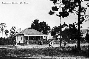
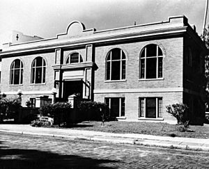
Manatee County's first public library was a private one. Julia Fuller started it in 1898 at Mrs. Bass Dry Goods store. The first independent library opened in Bradenton in 1907. Then, a Carnegie Library opened in Palmetto in 1914, and another in Bradenton in 1918.
For many years, city residents could use these libraries for free. But county residents had to pay a fee. In 1964, the Bradenton and Palmetto libraries joined with the Manatee County government. This created the Manatee County Public Library System. A bookmobile started in 1964 to serve rural areas. A program for blind people began in 1966.
As more people used the bookmobile, new library buildings were needed. The first branch of the Manatee County Public Library system was built in Bayshore in 1967. More branches followed in 1969 and 1971. The Island branch moved to a new building in 1983. A new building for the Palmetto Library was built in 1969. The modern Central Public Library in downtown Bradenton opened in 1978.
The 1990s saw fast growth in Manatee County. The library system grew too. The Braden River, Rocky Bluff, and South Manatee branches opened in 1991, 1994, and 1998. The Braden River branch moved to a new building in 1997. The Rocky Bluff location moved to a larger building with a cafe in 2011.
Today, Manatee County Libraries offer many modern services. These include new computers, a 3-D Printing Lab, and new items to borrow.
In 2000, libraries in Manatee and Sarasota counties started letting people borrow from both systems. This led to statewide borrowing programs. Starting in 2017, the Manatee County library system began lending unusual items. These include musical instruments, tools, telescopes, and museum passes. During the COVID-19 Pandemic, the library started lending WiFi hotspots. This helped people get internet service at home for work and school.
On December 15, 2021, work began on a new East County library. It was built to serve the Lakewood Ranch community. The new Lakewood Ranch Library opened on January 12, 2024.
Education
Schools for Kids and Teens
- Manatee County School District – This public school district serves all students from kindergarten to 12th grade in Manatee County.
Colleges and Universities
- Lake Erie College of Osteopathic Medicine (LECOM) Bradenton – A private school for graduate studies in medicine, dentistry, and pharmacy.
- State College of Florida, Manatee–Sarasota (SCF) – A public four-year college with a campus in Manatee County.
- University of South Florida Sarasota-Manatee campus (USF) – A public research university.
Communities
Cities
Town
- Longboat Key (part of this town is in Manatee County)
Census-Designated Places (CDPs)
- Bayshore Gardens
- Cortez
- Ellenton
- Lakewood Ranch (part of this CDP is in Manatee County)
- Memphis
- Samoset
- South Bradenton
- West Bradenton
- West Samoset
- Whitfield
Unincorporated Places
Transportation
Manatee County has its own transportation service called MCAT. It serves Manatee, Pinellas, and Sarasota counties.
Airports
- Sarasota–Bradenton International Airport
- Airport Manatee 48X, a smaller local airport.
Major Highways
 Interstate 75 – This is the main north-south highway in the county.
 Interstate 275 – This highway starts near Palmetto and includes the Sunshine Skyway Bridge.
U.S. Highways
 U.S. Route 19
 U.S. Route 41, Tamiami Trail
 U.S. Route 301
State and County Roads
 State Road 64
 State Road 70
 State Road 684 (Cortez Road)
 State Road 789
 State Road 62
 State Road 37
 Rutland Road
 University Parkway
Waterways
Ports
- SeaPort Manatee
See also
 In Spanish: Condado de Manatee para niños
 | Selma Burke |
 | Pauline Powell Burns |
 | Frederick J. Brown |
 | Robert Blackburn |


