
Whitfield, Manatee County, Florida facts for kids
Quick facts for kids
Whitfield, Florida
Whitfield Estates
|
|
|---|---|

Location in Manatee County and the state of Florida
|
|

Whitfield, Manatee County, Florida
Location in the United States
|
|
| Country | United States |
| State | Florida |
| County | Manatee |
| Area | |
| • Total | 1.40 sq mi (3.62 km2) |
| • Land | 1.38 sq mi (3.57 km2) |
| • Water | 0.02 sq mi (0.05 km2) |
| Elevation | 16 ft (5 m) |
| Population
(2020)
|
|
| • Total | 2,989 |
| • Density | 2,167.51/sq mi (836.74/km2) |
| Time zone | UTC−05:00 (EST) |
| • Summer (DST) | UTC−04:00 (EDT) |
| ZIP Code |
34243 (Sarasota)
|
| Area code(s) | 941 |
| FIPS code | 12-77467 |
| GNIS feature ID | 1867236 |
Whitfield, also known as Whitfield Estates, is a small community in Manatee County, Florida, United States. It's called a census-designated place (CDP) because it's a special area used for gathering population information.
In 2020, about 2,989 people lived in Whitfield. This community is part of a larger area that includes the cities of North Port, Sarasota, and Bradenton. Even though Whitfield is in Manatee County, its mail comes from the Sarasota post office, which is in Sarasota County.
Contents
History of Whitfield Estates
Whitfield Estates was once a large, wooded area covering about 682 acres. It used to belong to General John Riggin, who was an important helper to Ulysses S. Grant, a famous U.S. President. Part of this land, about 218 acres, was also owned by Alfred Ringling, one of the famous Ringling brothers who started the circus.
In 1924, a company called Whitfield Estates, Inc. bought the land from Alfred Ringling's son. This company was owned by Louis Broughton Whitfield and a few others from Alabama. Louis Whitfield was the main person behind the development. He was also the founder of the Alaga Syrup Company. Many streets in Whitfield Estates, like Broughton and Pearl, are named after his family.
Early Plans and Challenges
The original idea for Whitfield Estates was to build a big neighborhood with homes, a golf course, a hotel, a place for yachts, and even man-made islands in the bay. A famous golf course designer named Donald Ross was hired to create the golf course.
However, things changed. In late 1925 or early 1926, Louis Whitfield left the project. Another company, Adair Realty, took over. In 1926, the growing neighborhood officially became a city, with E.S. Bond as its first mayor.
Like many other projects during the Florida Land Boom, Whitfield Estates didn't quite reach all its big goals. One sign of trouble was when the Whitfield Estates Country Club had to let people from Sarasota and Bradenton join if they helped pay for its running costs. After the land boom ended, many residents found it hard to stay in their homes. Some houses were rented out many times, and others that were being built were left unfinished for years.
The Great Depression and Recovery
The Great Depression, which started with the 1929 stock market crash, made things even tougher for people in Whitfield. Very little new construction happened during these years.
In 1937, a group of club members bought the golf course and clubhouse. They renamed it the "Sarasota Bay Country Club." In 1938, it was renamed again to "North Shore Country Club." During World War II, the club had to close because people couldn't get enough gasoline or golf balls. The golf course became overgrown, but after the war, the U.S. Army helped restore it.
Whitfield Estates started to grow again after World War II. It was close to the Sarasota Army Airfield, which made it a popular place for families to move to after the war. This helped the community recover. The Whitfield Community Improvement Association was started in the mid-1940s to help improve the area. The golf club was given its current name, "Sara Bay Country Club," in 1964.
Historic Places in Whitfield
Several important buildings and areas in Whitfield Estates are listed on the National Register of Historic Places. This means they are recognized for their historical importance and are protected.
- Whitfield Estates–Broughton Street Historic District: This area includes several historic homes on Broughton Street.
- John M. Beasley House: A historic house located on Westmoreland Drive.
- Whitfield Estates–Lantana Avenue Historic District: Another historic area on Lantana Avenue.
- Austin House: A historic house on Delmar Avenue.
- Reid-Woods House: A historic house located on Whitfield Avenue.
- Villa Serena Apartments: Historic apartment buildings on Willow Street.
- Paul M. Souder House: A historic house on Greenwood Avenue.
- Stevens–Gilchrist House: A historic house on Delmar Avenue.
Most of these places were added to the National Register as part of a larger study of the Whitfield Estates Subdivision in 1996.
Geography and Location
Whitfield is located in the southern part of Manatee County, right on the northeast shore of Sarasota Bay. To its north is Bowlees Creek and another community called Bayshore Gardens. To the southeast, you'll find the Sarasota–Bradenton International Airport.
Whitfield is about 6 miles (10 km) north of the center of Sarasota. It's also about the same distance south of Bradenton, which is the main city in Manatee County.
The community covers a total area of about 1.4 square miles (3.6 square kilometers). A small part of this area, about 0.02 square miles (0.05 square kilometers), is water.
Population and People
The number of people living in Whitfield has changed over the years:
| Historical population | |||
|---|---|---|---|
| Census | Pop. | %± | |
| 1990 | 3,152 | — | |
| 2000 | 2,984 | −5.3% | |
| 2010 | 2,882 | −3.4% | |
| 2020 | 2,989 | 3.7% | |
| Source: | |||
In 2000, there were 2,984 people living in Whitfield. Most of the people were White (94.27%), with smaller percentages of African American, Asian, Native American, and other groups. About 4.73% of the population was Hispanic or Latino.
There were 1,244 households, and about 21.9% of them had children under 18 living there. Many households (58.0%) were married couples. The average household had about 2.40 people.
The median age in Whitfield in 2000 was 44 years old. This means half the people were younger than 44, and half were older. About 17.9% of the population was under 18, and 20.7% were 65 or older.
The median income for a household in Whitfield was $51,536. This means half the households earned more than this amount, and half earned less. About 6.3% of the total population lived below the poverty line.
Images for kids
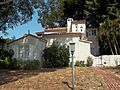
-
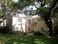
A historic home in the Whitfield Estates–Broughton Street Historic District.
-
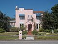
The John M. Beasley House.
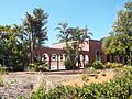
-
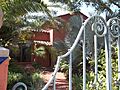
A building in the Whitfield Estates–Lantana Avenue Historic District.
-
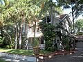
The Austin House.
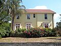
-
The Reid-Woods House.
-
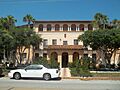
The Villa Serena Apartments.
-
The Paul M. Souder House.
-
The Stevens–Gilchrist House.


See also
 In Spanish: Whitfield (condado de Manatee) para niños
