Old Ghost Road facts for kids
Quick facts for kids Old Ghost Road |
|
|---|---|

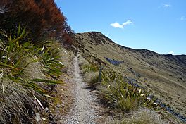
Trail section between Bald Hill and Mt Montgomery
|
|
| Length | 85 km (53 mi) |
| Location | Buller District, New Zealand |
| Trailheads | Lyell / Seddonville |
| Use | mountain biking tramping |
| Highest point | 1,280 m (4,200 ft) |
| Difficulty | Advanced |
| Season | Year round |
| Sights | Lyell Range Several ghost towns New Zealand old-growth forest Mōkihinui River |
| Hazards | Cliffs Exposure to weather change |
The Old Ghost Road is an amazing trail in the Buller District of New Zealand. It's perfect for both mountain biking and tramping (which is like hiking). This trail is part of the New Zealand Cycle Trail (NZCT) system.
It's known as one of the toughest trails in the NZCT network. It's rated "advanced" (Grade 4 out of 5) for mountain biking. The highest point you'll reach on the trail is 1280 meters (about 4,200 feet) above sea level.
History of the Old Ghost Road
Early Tracks in the 1800s
Back in the 1860s, during the West Coast Gold Rush, a town called Lyell was founded. It was on the Buller River. People built a road for horse-drawn carts (a "dray road") towards Lyell Saddle. This road helped miners reach gold mines and towns.
Another dray road started near Seddonville and followed the Mōkihinui River. This was the first way to get to Karamea by land. In 1886, people planned to connect these two roads. Over time, parts of these old roads were lost. Earthquakes in 1929 and 1968 caused landslides, making them impossible to use.
The Rough & Tumble Lodge and a Dam Idea

In 2002, Marion Boatwright and his wife Susan Cook found an old farm area. It was at the end of the Mōkihinui Gorge. They thought it would be a great place for a lodge. They bought the land and built the lodge themselves. It opened in December 2006.
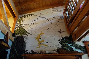
A local artist painted a big picture (a mural) of the Mōkihinui area above the lodge's fireplace. The artist's friend, Steve Stack, knew the local wilderness very well. He and Boatwright became good friends.
Before the lodge opened, Boatwright and Cook learned about a plan. A company called Meridian Energy wanted to build a dam on the Mōkihinui River. The dam would be very close to their property. They would have to move away for three years during construction.
Exploring the Old Trail Route
Boatwright and his wife talked to Bob Dickson, who managed the local Department of Conservation (DoC). They learned that a planned tramping route along the Mōkihinui Gorge was part of a much older, unfinished road.
In early 2007, Boatwright received an original map from 1886. It showed a "Lyell and Mokihinui Road." The map's owner believed the Rough & Tumble lodge was the right place to keep old local items. The map showed the planned route. It followed the Mōkihinui River, then its south branch, and went over the Lyell Range towards Lyell township.
In July 2007, Boatwright and Stack decided to walk this old route. They wanted to see how much of the road was built. They also wanted to know if it was easy to get to and if it would be a nice place for tramping. They found that the track from Lyell stopped at Lyell Saddle. Nothing had been built along the south branch of the Mōkihinui.
Their six-day trip showed that more than half of the planned road was never built. Also, much of the part that was built along the Mōkihinui River was at risk of being flooded by the proposed dam.
Forming the Mokihinui-Lyell Backcountry Trust
Boatwright decided to create a group to work on the idea of a long-distance track. Phil Rossiter, who worked for a coal mine and loved mountain biking, joined first. His company wanted to help the local community.
Next, Wayne Pratt joined. He had helped create the Hump Ridge Track and could provide helicopter access. When DoC manager Bob Dickson supported the idea, the group formed the Mokihinui-Lyell Backcountry Trust (MLBT) in July 2008. Meridian Energy helped pay for the trust to get started. They also agreed that if the dam was built, they would build a new track above the water level to make up for it.
The trust started to figure out how much the track would cost. With help from Meridian Energy, a DoC expert named Mal Hansen flew into the south branch area. Hansen, Stack, and Boatwright explored the old route. They realized it would have been very hard to build in the 1880s. Earthquakes in the 1900s made it even harder. They found that they would need at least 35 bridges. Based on this, a DoC staff member estimated the trail would cost about NZ$7.3 million.
Working on the Lyell Track Section
By late 2008, the trust decided to stop exploring along the Mōkihinui River. This was because of the uncertainty about the dam. They also faced some criticism for working closely with Meridian Energy.
Instead, they focused on clearing the existing old road from Lyell up to the first landslide. DoC suggested clearing a helicopter landing area at Lyell Saddle. This would make it safer to get there and allow for a hut to be built. On January 18, 2009, they cleared the area at Lyell Saddle. This was the real start of building the Old Ghost Road.
Volunteers spent weekends cutting down fallen trees. Soon, the route was walkable. By winter 2009, DoC suggested hiring diggers to remove landslides. But then, a huge rainstorm hit, bringing thousands of trees and tons of debris onto the track. It took five weeks to clear it all.
Once the track's steady slope was clear, Phil Rossiter suggested a big change. Instead of just a tramping route, he proposed making it a mountain biking track. The trust agreed.
There were two huge landslides on the Lyell track that left almost vertical rock faces. Rossiter, who studied geology, explained that the crumbly rock needed to be chipped away by hand. A camp was built for 14 volunteers. Over several weekends, the crew hand-built a track across these difficult sections.
Getting Funding from the New Zealand Cycle Trail
In late 2009, the trust heard that the New Zealand Cycle Trail (NZCT) project had $50 million available for new trails. Bob Dickson from DoC warned them that their project had a very small chance of getting money.
But Boatwright didn't give up. He went to a workshop in Christchurch. He was the only one representing a group of volunteers. Everyone else was from city or district councils. The NZCT wanted groups to tell their project's story, how much money they needed, and where they would get other funding. Boatwright wrote the application, and the trust asked for $2 million. John Dunn, the NZCT project manager, told Boatwright that the Old Ghost Road was the top-ranked project out of 18 proposals!
The next step was to do a study to see if the project was possible. Stack went to explore the south branch area to find a good track route. He was supposed to meet the other trustees a week later. When he arrived, his face showed that the south branch of the Mōkihinui River couldn't make their dream come true.
Wayne Pratt, the helicopter pilot, offered to fly them along the Lyell Range. He had often wondered if a track could go along the mountain tops instead of following the river. On that flight, they found the perfect route! It would go from Lyell Saddle to Goat Creek Hut, where it would rejoin the Mōkihinui River's south branch. It looked perfect, but building it would be incredibly hard.
A week later, Stack and Boatwright walked south from Goat Creek Hut. They met Rossiter and a geologist, Brian Adams, who had started from Bald Hill. The route looked possible. DoC also supported the new route. Everyone agreed it was a game-changer, even though building it through the mountains would be very challenging. The NZCT accepted the study. The final step was to get all the funding partners to agree. In May 2010, everyone committed their share.
Development West Coast (DWC), a group set up to help the West Coast, agreed to provide funding. Solid Energy would pay for the backcountry huts. The Department of Conservation would take care of the Lyell part of the track. The Buller District Council would help maintain the mountain sections and the track along the south branch. The NZCT also agreed to wait until the Meridian Energy dam proposal was decided before working on the Mōkihinui Gorge section. Rossiter's wife, Di, then helped get funding for 15 of the 17 bridges needed for the trail.
Building the Bald Hill Section
The trustees divided the work. Rossiter handled the paperwork and talked with partners. Stack became a full-time employee and led the track workers. Boatwright was in charge of building huts for the workers. Rossiter also took over as chairman of the trust because Boatwright was moving back to North Carolina. Boatwright would return to New Zealand for a few weeks at a time to help build huts.
Stack led a crew to build and fix the rest of the Lyell track above the landslides. Boatwright came back from the United States in March and April 2011. He led the building of the Lyell Saddle Hut. The hut was ready just as the crew finished the track from below.
With the new hut as a base, Stack and his crew started on the six kilometers of track up Bald Hill. The type of rock changed, making construction difficult. The weight of the digger would turn the soft rock into mud, making it impossible to build the track.
The solution was to use a method called "corduroy road" construction. They cut beech trees lengthwise to make logs. One team member cut enough logs for 15 meters (about 50 feet) of track each day. It was very hard work, and Stack's team spent over a year building the track up to the mountain tops.
Building More Huts
Later in 2011, Boatwright built the Stern Valley Hut with his brother and a builder friend. In January 2012, Boatwright built Ghost Lake Hut with two friends. It took them 19 days. This hut sits at over 1200 meters (about 3,900 feet) high, on top of a 100-meter (about 330-foot) tall cliff.
On May 22, 2012, Meridian Energy announced they had canceled the Mokihinui Hydro dam plan. The trust quickly moved crews from the high mountains into the Mōkihinui Gorge. Boatwright and three friends built Specimen Point Hut. This hut served as a winter base for the track builders.
What's in a Name?
In late 2007, Boatwright was thinking of a name for the track. He thought of the old Lyell and Mokihinui Road as a "ghost" of a road. This gave him the idea of "Ghost Road." When he talked about it with other trust members, Richard Little suggested adding "old" to it. That's how it became the "Old Ghost Road."
 | Stephanie Wilson |
 | Charles Bolden |
 | Ronald McNair |
 | Frederick D. Gregory |


